James Wyld
44 x 55 cm
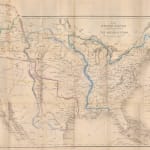
This is a very good example of James Wyld’s rare, separately issued map of the United States published to illustrate the events leading up to the Oregon Treaty of 1846.
It forms part of a collection of maps issued by Wyld which illustrate important news events of the day. The boundary dispute between the United States and the British government in the Pacific Northwest of America had been rumbling on for decades but it gained much greater urgency due to the deteriorating situation in the much tenser southwest region over the status of the independent Texas Republic, the claims of the Mexican government that it was a rebel province and the petition by the Republic to join the United States. The position of Mexico was that acceptance by the United States was an immediate “casus belli” or cause for war. The strategic position of the United States with a hostile British government in the north and a hostile Mexican government in the south was not tenable.
As he often did, Wyld has used one of his existing maps as a base for the geographical illustration of the current situation. In this case, it is one of the maps inserted in later issues of his “General Atlas” with the same title as this map. The main difference between the base maps is that the former is a lithograph, while this map is a zincograph, or a less expensive, faster method of printing which Wyld developed and used for these ephemeral “event” maps.
The map has been simplified to highlight its salient purpose of showing the historical developments of the United States, from its foundation in 1783 at the Treaty of Paris with sequential growth, proposals and current borders outlined in bright bold, differently coloured outlines. In turn, these colours are keyed on a panel on the right.
The historical outlines include the earliest iteration of the United States with the Mississippi River as a western border and the Louisiana Purchase in its original form referring to its Patent granted to Antoine Crozat in 1712. As well as historical borders, the map also shows "modern" borders with the “current” boundaries between California and the United States as designated by the Adams Onis Treaty of 1819 between the United States and Spain, called the Treaty of Florida on this map. This line was further confirmed in the Treaty of Limits of 1828, the first Treaty between the United States and Mexico and used on this map as a continuation of the Adams Onis Line. Despite its dispute by Mexico, it was generally accepted as the western border of the USA at this time.
Although Texas is not mentioned on any of the historical treaties, it is clearly separated from both the United States and Mexico as an independent Republic, with the line of the Adams Onis Treaty acting as its eastern border and the Rio Grande as its western limit. Its territorial claims at this time include the famous “stovepipe” which follows the Rio Grande to its source and the eastern limit to the northern edge of the Adams Onis Line.
The northern limit of the United States is referenced by the “Convention of 1818” originally a treaty between Great Britain and the United States agreeing to set the border between the Missouri Territory and Canada at the 49th parallel. Beyond the Rocky Mountains, the map illustrates several claims and counterclaims by the British, the United States and the Russians. The map also references the Russo-American Treaty of 1824 in the Pacific Northwest, agreed by the two countries without the participation of Great Britain.
A further curiosity is the yellow line running from the western coast to modern Oklahoma, labelled “Line proposed to Mexico by the United States in 1835” a reference to an amendment of the Treaty of Limits suggesting a border change. It was never accepted by Mexico.
The map is extremely rare commercially. It is present in institutional collections but it is difficult to identify as Wyld used the base map with the same title for several if his “event” maps, with a particularly well-known example issued for the Civil War. We have been able to identify five examples in institutional collections all matching the date 1845 of our example.
Both historically and aesthetically this map is of extreme interest with its emphasis on the contemporaneous geo-political foundations of the western United States.
Original colour. [USA9422]
Join our mailing list
* denotes required fields
We will process the personal data you have supplied to communicate with you in accordance with our Privacy Policy. You can unsubscribe or change your preferences at any time by clicking the link in our emails.


