Georg Braun & Frans Hogenberg
75 x 50 cm
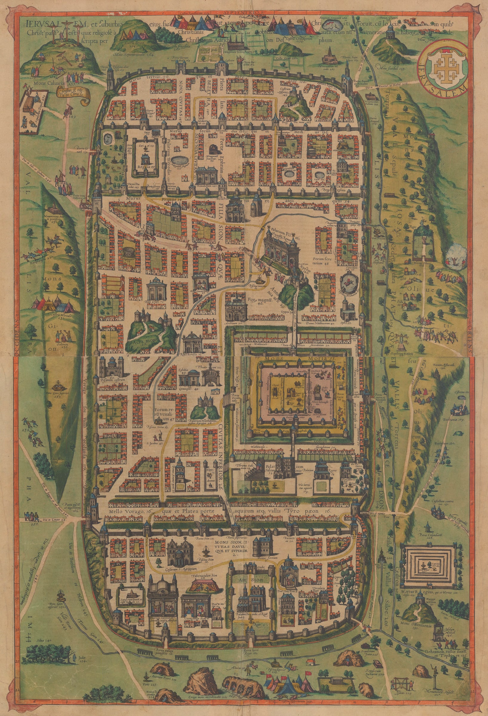
Jerusalem et Suburbia
Famed
two-sheet map of ancient Jerusalem during the Biblical period and based on the
Old Testament.
This
map is the rarest of the three maps of Jerusalem produced by Georg Braun and
Franz Hogenberg. It appeared in the 1588 published Volume IV (page 58-59) of
their landmark “Civitates Orbis Terrarum” [Cities of the World], the first
atlas dedicated to city maps.
The
geography of the map is purely imaginary, and based solely on the description
and 1584 map by Christian van Adrichom. It is said that when Adrichom died in
1585, the manuscript of the map was ‘left in the hands of another Catholic
refugee in Cologne, Georg Braun’ (Nebenzahl).
The map features 270 numbered place
names and events described in the Old Testament. On the reverse of the map a
listing of these numbered events. Included are the fourteen stations of the
cross (along the “Way of the Cross”) depicted across the map, making them the
officially accepted locations in the Catholic faith. Mount Moria[h] and the
Temple of Solomon can be seen in the lower-centre right. The City of David and Mount Sion can be found
in the south quarter of the map within the city walls. Mount Cavalry featuring
the site of the Crucifixion and camps in the north.
Andrichom
(1533-1585) was a noted Biblical scholar from Delft and based in Cologne at a
time it was a thriving centre of publishing and cartography. The map used his
research of the Bobcather than any first-hand accounts or surveys. Adrichom
himself may have used the description of biblical Jerusalem first written by
the medieval scholar, Petro Lackstein. Adrichom is also believed to have used
Christian Sgrooten, cartographer to Philip II of Spain, to issue his own
version of this map contemporaneously to Braun & Hogenberg. Andrichom's
important historical atlas "Theatrum Terrae Sanctae, et Biblicarum
Historiarum" was published posthumously in 1590.
Between
1572 and 1618, Georg Braun (1541-1622) and Frans Hogenberg (1535-1590) produced
six volumes of the "Civitates Orbis Terrarum", comprising over five
hundred city views and plans. Though city plans had been included in earlier
atlases, no previous work had been devoted solely to the depiction of the known
cities of the world. Nor was the "Civitates" entirely Eurocentric: it
also included famous plans of Mexico City, Goa, Jerusalem and many other
African and Asian cities. Each volume was originally published with Latin text.
Volumes I and II were the most popular and were reissued several times to meet
growing demand. Editions were also published with German and French text rather
than Latin. Many of the maps feature costumed figures in the foreground of the
scene, making this an important record of contemporary dress and behaviour as
well as geography.
The
atlas was published in Cologne by Georg Braun with assistance from the engraver
Frans Hogenberg and the artist Georg Hoefnagel. It was issued at a time when
Europe was in the midst of religious and political turmoil during the
Protestant Reformation and the subsequent Counter-Reformation. This, in part,
explains the haphazard organisation of the work, as maps of cities in troubled
regions might not have been available to Braun & Hogenberg during the
publication of one volume, but might have become available later and were therefore
shoehorned into a later edition. It also speaks to the skill and political will
required to amass such an enormous collection of city maps, as well as to the
strength of the scientific networks across Europe at the time that mayors,
clergymen, and nobles, sometimes representing very small towns or villages,
could send a map to Cologne and have it included in the next volume of the
"Civitates".
Hogenberg,
who engraved many of the plates, was also the engraver for Abraham Ortelius's “Theatrum
Orbis Terrarum”, the first modern world atlas. Georg Hoefnagel (1542-1600) is
seldom credited with the part he played in the project, but he was, in fact, its
biggest contributor, supplying 63 drawings, gleaned from travels in Germany,
France and England in the 1560s. His landscape style is a distinguishing
feature of his work. Hoefnagel himself is often depicted in the foreground of
the views, sometimes accompanied by his travelling companion, Abraham Ortelius.
After
1618, control of the work passed to Abraham Hogenberg, who supervised further
editions. Jan Jansson acquired the plates and reissued the volumes in Amsterdam
in 1657 often without the costumed figures in the foreground as these would
make the maps, some of which were now over 80 years old, look quite dated. The
copperplates later went through the hands of two other Amsterdam-based
publishers, Frederick de Wit and Pieter van der Aa, a testament to their
continuing commercial popularity.
Manuscript corner decoration. Latin
text on verso. Rich original hand colour. [Kenneth Nebenzahl: "Maps of the Holy
Land". No. 33 (1986)]
Literature
Kenneth Nebenzahl: "Maps of the Holy Land". No. 33 (1986)Join our mailing list
* denotes required fields
We will process the personal data you have supplied to communicate with you in accordance with our Privacy Policy. You can unsubscribe or change your preferences at any time by clicking the link in our emails.
![]()
Join our mailing list
* denotes required fields
We will process the personal data you have supplied to communicate with you in accordance with our Privacy Policy. You can unsubscribe or change your preferences at any time by clicking the link in our emails.