- All
- AFRICA
- ▪ Central Africa
- ▪ East Africa
- ▪ North Africa
- ▪ Southern Africa
- ▪ West Africa
- ▪ Atlantic Islands
- AMERICAS
-
▪ United States (USA)
- USA - East
- USA - Midwest
- USA - Northeast
- USA - Southeast
- USA - West & Southwest
- Alabama
- Alaska
- Arizona
- Arkansas
- California
- Colorado
- Connecticut
- Delaware
- Florida
- Georgia
- Hawaii
- Idaho
- Illinois
- Indiana
- Iowa
- Kansas
- Kentucky
- Louisiana
- Maine
- Maryland
- Massachusetts
- Michigan
- Minnesota
- Mississippi
- Missouri
- Montana
- Nebraska
- Nevada
- New Hampshire
- New Jersey
- New Mexico
- New York
- New York City
- North Carolina
- North Dakota
- Ohio
- Oklahoma
- Oregon
- Pennsylvania
- Rhode Island
- South Carolina
- South Dakota
- Tennessee
- Texas
- Utah
- Vermont
- Virginia
- Washington
- Washington, D.C.
- West Virginia
- Wisconsin
- Wyoming
- ▪ North America
- ▪ South America
- ▪ Caribbean
- ASIA
- ▪ East Asia
- ▪ Southeast Asia
- ▪ India & South Asia
- ▪ Middle East & Turkey
- BRITISH ISLES
- ▪ London
-
▪ England
- English Cities
- Bedfordshire
- Berkshire
- Buckinghamshire
- Cambridgeshire
- Cheshire
- Cornwall
- Cumbria
- Derbyshire
- Devon
- Dorset
- Durham
- Essex
- Gloucestershire
- Hampshire
- Herefordshire
- Hertfordshire
- Huntingdonshire
- Isle of Wight
- Kent
- Lancashire
- Leicestershire
- Lincolnshire
- Middlesex
- Norfolk
- Northamptonshire
- Northumberland
- Nottinghamshire
- Oxfordshire
- Rutland
- Shropshire
- Somerset
- Staffordshire
- Suffolk
- Surrey
- Sussex
- Warwickshire
- Wiltshire
- Worcestershire
- Yorkshire
- Yorkshire East Riding
- Yorkshire North Riding
- Yorkshire West Riding
- ▪ Ireland
- ▪ Scotland
- ▪ Wales
- EUROPE
- ▪ Austria & Switzerland
- ▪ Benelux Region
- ▪ Central & Eastern Europe
- ▪ France & Monaco
- ▪ Germany
- ▪ Greece
- ▪ Italy
- ▪ Mediterranean Sea
- ▪ Spain & Portugal
- ▪ Scandinavia & Baltics
- ▪ Russia, Ukraine & Caucasus
- OCEANIA
- ▪ Australia
- ▪ New Zealand
- ▪ Pacific Ocean & Islands
- ▪ Papua New Guinea
- POLAR
- CELESTIAL
- WORLD
- GLOBES & INSTRUMENTS
- THEMATIC
- COLLABORATIONS
John Bartholomew & Co.
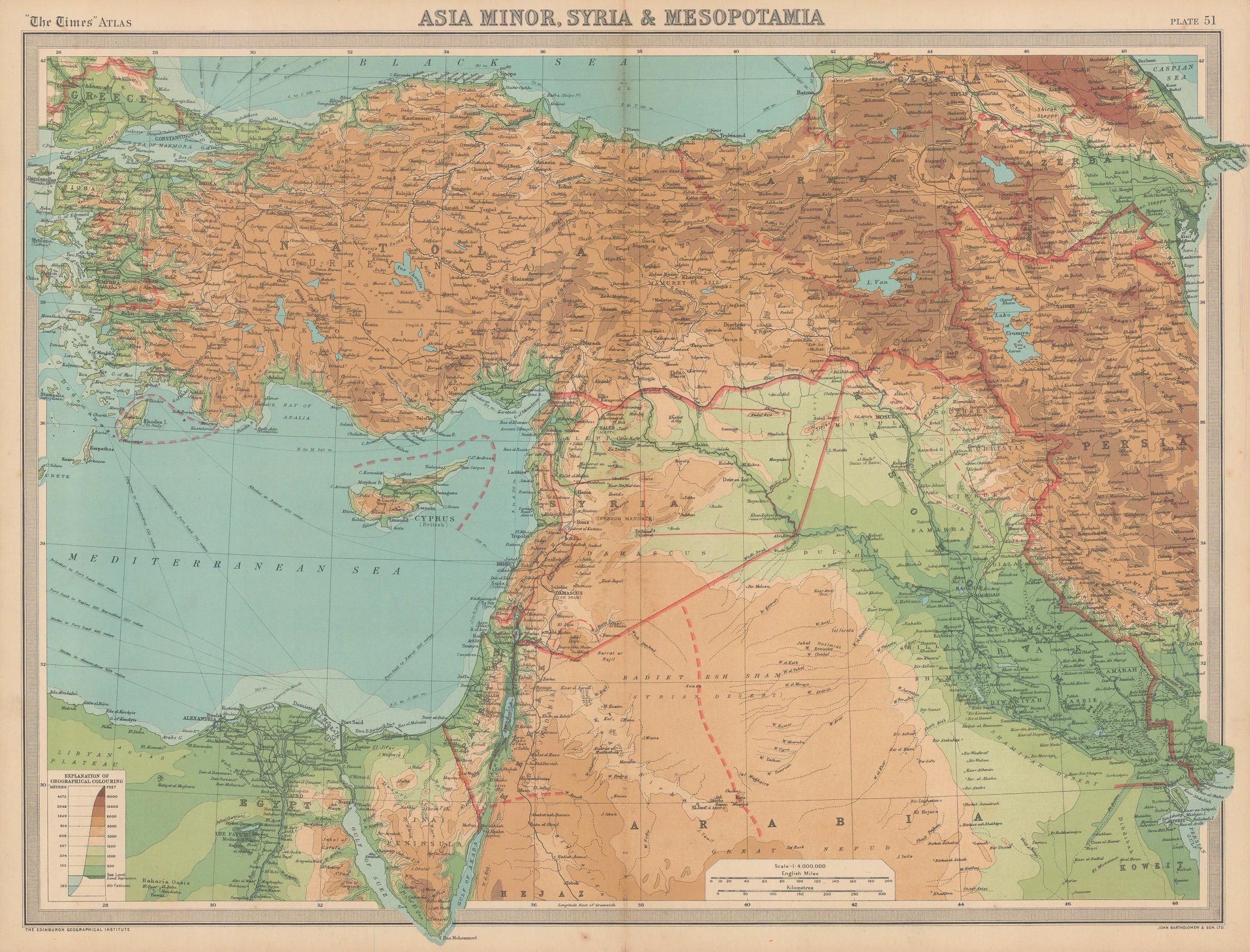
Inter-war map of Turkey, Iraq, and the Levant, 1922
17 1/2 x 22 in
44 x 56 cm
44 x 56 cm
MEAST4510
£ 395.00
John Bartholomew & Co., Inter-war map of Turkey, Iraq, and the Levant, 1922
Sold
%3Cdiv%20class%3D%22artist%22%3EJohn%20Bartholomew%20%26%20Co.%3C/div%3E%3Cdiv%20class%3D%22title_and_year%22%3E%3Cspan%20class%3D%22title_and_year_title%22%3EInter-war%20map%20of%20Turkey%2C%20Iraq%2C%20and%20the%20Levant%3C/span%3E%2C%20%3Cspan%20class%3D%22title_and_year_year%22%3E1922%3C/span%3E%3C/div%3E%3Cdiv%20class%3D%22dimensions%22%3E17%201/2%20x%2022%20in%3Cbr/%3E%0A44%20x%2056%20cm%3C/div%3E
Asia Minor, Syria & Mesopotamia A map of Turkey, Iraq, Syria, Lebanon, Israel, Palestine, Jordan, Egypt, Armenia, Azerbaijan, and western Iran. This map is of great interest as it...
Asia Minor, Syria & Mesopotamia
A map of Turkey, Iraq, Syria, Lebanon, Israel, Palestine, Jordan, Egypt, Armenia, Azerbaijan, and western Iran. This map is of great interest as it shows some important geo-political features of the interwar period which still reverberate in world affairs to this day.
The first of these is the clear marking of the Sykes-Picot Line across the Levant which divided French Syria from British Palestine. Second is the inclusion of “Wilsonian Armenia”, or the borders claimed by the Armenian Republic at the Treaty of Sevres. President Wilson of the United States supported Armenia's claims, hence the name, which included former Ottoman territory in eastern Anatolia, access to the southern shores of the Black Sea, and the city of Erzurum. Thirdly, the map also shows the short lived Greek ownership of Smyrna (Izmir), granted to the Greeks after the War by the Treaty of Sevres.
Printed colour.
Share
- Tumblr
Join our mailing list
* denotes required fields
We will process the personal data you have supplied to communicate with you in accordance with our Privacy Policy. You can unsubscribe or change your preferences at any time by clicking the link in our emails.
Contact
The Map House
54 Beauchamp Place,
London SW3 1NY,
United Kingdom
maps@themaphouse.com
+44 (0)20 7589 4325
![]()
Copyright © 2025 The Map House
This website uses cookies
This site uses cookies to help make it more useful to you. Please contact us to find out more about our Cookie Policy.