- All
- AFRICA
- ▪ Central Africa
- ▪ East Africa
- ▪ North Africa
- ▪ Southern Africa
- ▪ West Africa
- ▪ Atlantic Islands
- AMERICAS
-
▪ United States (USA)
- USA - East
- USA - Midwest
- USA - Northeast
- USA - Southeast
- USA - West & Southwest
- Alabama
- Alaska
- Arizona
- Arkansas
- California
- Colorado
- Connecticut
- Delaware
- Florida
- Georgia
- Hawaii
- Idaho
- Illinois
- Indiana
- Iowa
- Kansas
- Kentucky
- Louisiana
- Maine
- Maryland
- Massachusetts
- Michigan
- Minnesota
- Mississippi
- Missouri
- Montana
- Nebraska
- Nevada
- New Hampshire
- New Jersey
- New Mexico
- New York
- New York City
- North Carolina
- North Dakota
- Ohio
- Oklahoma
- Oregon
- Pennsylvania
- Rhode Island
- South Carolina
- South Dakota
- Tennessee
- Texas
- Utah
- Vermont
- Virginia
- Washington
- Washington, D.C.
- West Virginia
- Wisconsin
- Wyoming
- ▪ North America
- ▪ South America
- ▪ Caribbean
- ASIA
- ▪ East Asia
- ▪ Southeast Asia
- ▪ India & South Asia
- ▪ Middle East & Turkey
- BRITISH ISLES
- ▪ London
-
▪ England
- English Cities
- Bedfordshire
- Berkshire
- Buckinghamshire
- Cambridgeshire
- Cheshire
- Cornwall
- Cumbria
- Derbyshire
- Devon
- Dorset
- Durham
- Essex
- Gloucestershire
- Hampshire
- Herefordshire
- Hertfordshire
- Huntingdonshire
- Isle of Wight
- Kent
- Lancashire
- Leicestershire
- Lincolnshire
- Middlesex
- Norfolk
- Northamptonshire
- Northumberland
- Nottinghamshire
- Oxfordshire
- Rutland
- Shropshire
- Somerset
- Staffordshire
- Suffolk
- Surrey
- Sussex
- Warwickshire
- Wiltshire
- Worcestershire
- Yorkshire
- Yorkshire East Riding
- Yorkshire North Riding
- Yorkshire West Riding
- ▪ Ireland
- ▪ Scotland
- ▪ Wales
- EUROPE
- ▪ Austria & Switzerland
- ▪ Benelux Region
- ▪ Central & Eastern Europe
- ▪ France & Monaco
- ▪ Germany
- ▪ Greece
- ▪ Italy
- ▪ Mediterranean Sea
- ▪ Spain & Portugal
- ▪ Scandinavia & Baltics
- ▪ Russia, Ukraine & Caucasus
- OCEANIA
- ▪ Australia
- ▪ New Zealand
- ▪ Pacific Ocean & Islands
- ▪ Papua New Guinea
- POLAR
- CELESTIAL
- WORLD
- GLOBES & INSTRUMENTS
- THEMATIC
- COLLABORATIONS
Edward Stanford
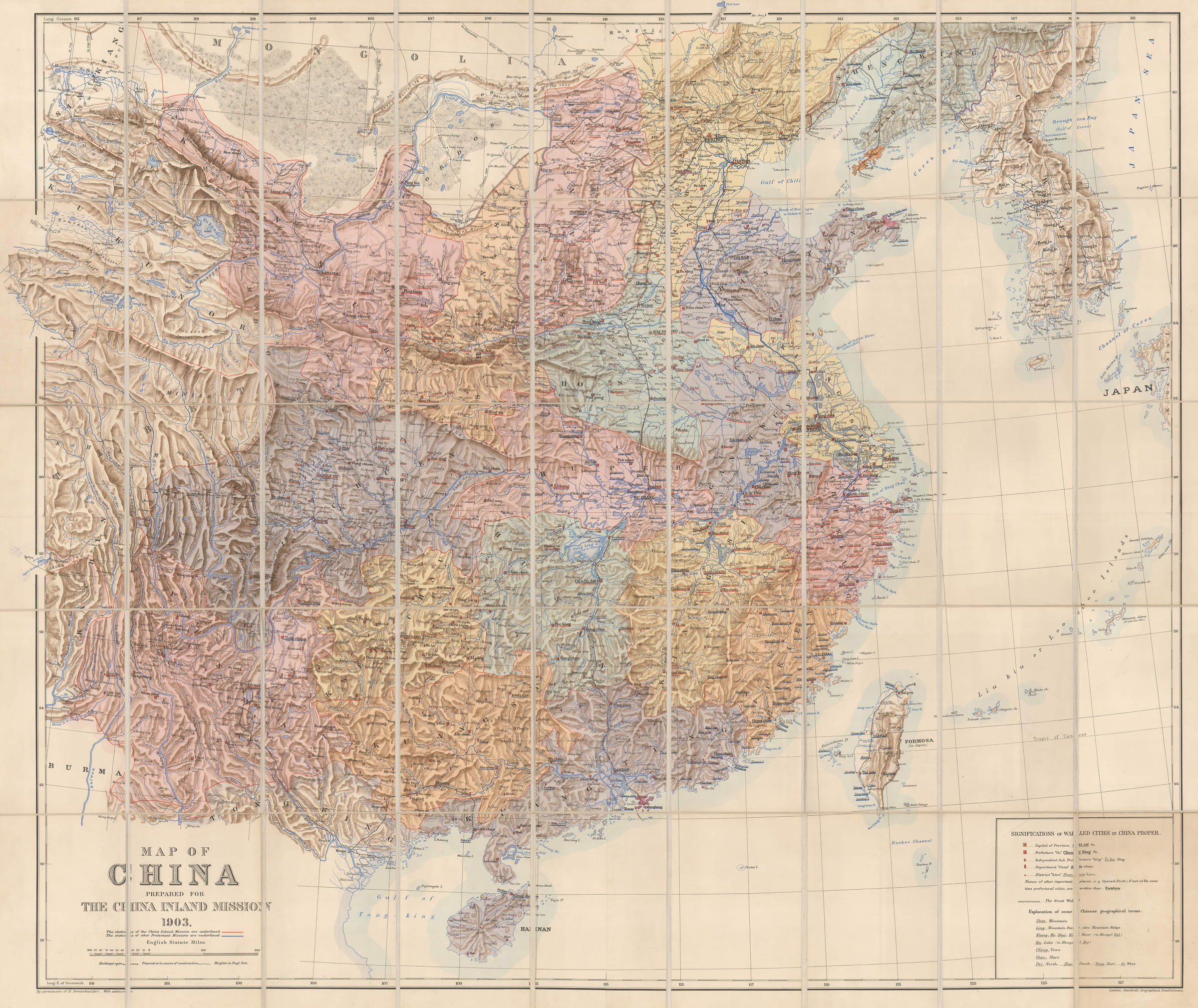
Map of China prepared for The China Inland Mission, 1903
36 ½ x 42 in
93 x 107 cm
93 x 107 cm
SEAS5193
£ 3,500.00
Edward Stanford, Map of China prepared for The China Inland Mission, 1903
Sold
%3Cdiv%20class%3D%22artist%22%3EEdward%20Stanford%3C/div%3E%3Cdiv%20class%3D%22title_and_year%22%3E%3Cspan%20class%3D%22title_and_year_title%22%3EMap%20of%20China%20prepared%20for%20The%20China%20Inland%20Mission%3C/span%3E%2C%20%3Cspan%20class%3D%22title_and_year_year%22%3E1903%3C/span%3E%3C/div%3E%3Cdiv%20class%3D%22dimensions%22%3E36%20%C2%BD%20x%2042%20in%3Cbr/%3E%0A93%20x%20107%20cm%3C/div%3E
Very attractive and highly detailed folding wall map of China and Korea prepared for the China Inland Mission, an Protestant Christian missionary organisation. This large wall map shows China divided...
Very attractive and highly detailed folding wall map of China and Korea prepared for the China Inland Mission, an Protestant Christian missionary organisation.
This large wall map shows China divided into its Provinces with the use of striking colour, and the impressive mountainous topography of the country is elegantly displayed with a soft lithographic technique. The map also marks road, railways and railways under constructions. The locations of stations of the China Inland Mission have been underlined in red, with other Protestant Missions underlined in blue.
The China Inland Mission was established in 1865 by James Taylor Hudson (1832-1905), a British Protestant missionary who spent 51 years in China. In 1964, the Mission became known as the Overseas Missionary Fellowship, or the OMF. It was around this time, or shortly after that missionaries were forbidden access to China.
In the lower right corner of the map there is a legend of the specifications of the Walled Cities, differentiating between their prefectures, departments, districts and explains the iconography used across the map to mark important buildings or other landmarks.
Printed colour. Folded.
Share
- Tumblr
Join our mailing list
* denotes required fields
We will process the personal data you have supplied to communicate with you in accordance with our Privacy Policy. You can unsubscribe or change your preferences at any time by clicking the link in our emails.
Contact
The Map House
54 Beauchamp Place,
London SW3 1NY,
United Kingdom
maps@themaphouse.com
+44 (0)20 7589 4325
![]()
Copyright © 2025 The Map House
This website uses cookies
This site uses cookies to help make it more useful to you. Please contact us to find out more about our Cookie Policy.