- All
- AFRICA
- ▪ Central Africa
- ▪ East Africa
- ▪ North Africa
- ▪ Southern Africa
- ▪ West Africa
- ▪ Atlantic Islands
- AMERICAS
-
▪ United States (USA)
- USA - East
- USA - Midwest
- USA - Northeast
- USA - Southeast
- USA - West & Southwest
- Alabama
- Alaska
- Arizona
- Arkansas
- California
- Colorado
- Connecticut
- Delaware
- Florida
- Georgia
- Hawaii
- Idaho
- Illinois
- Indiana
- Iowa
- Kansas
- Kentucky
- Louisiana
- Maine
- Maryland
- Massachusetts
- Michigan
- Minnesota
- Mississippi
- Missouri
- Montana
- Nebraska
- Nevada
- New Hampshire
- New Jersey
- New Mexico
- New York
- New York City
- North Carolina
- North Dakota
- Ohio
- Oklahoma
- Oregon
- Pennsylvania
- Rhode Island
- South Carolina
- South Dakota
- Tennessee
- Texas
- Utah
- Vermont
- Virginia
- Washington
- Washington, D.C.
- West Virginia
- Wisconsin
- Wyoming
- ▪ North America
- ▪ South America
- ▪ Caribbean
- ASIA
- ▪ East Asia
- ▪ Southeast Asia
- ▪ India & South Asia
- ▪ Middle East & Turkey
- BRITISH ISLES
- ▪ London
-
▪ England
- English Cities
- Bedfordshire
- Berkshire
- Buckinghamshire
- Cambridgeshire
- Cheshire
- Cornwall
- Cumbria
- Derbyshire
- Devon
- Dorset
- Durham
- Essex
- Gloucestershire
- Hampshire
- Herefordshire
- Hertfordshire
- Huntingdonshire
- Isle of Wight
- Kent
- Lancashire
- Leicestershire
- Lincolnshire
- Middlesex
- Norfolk
- Northamptonshire
- Northumberland
- Nottinghamshire
- Oxfordshire
- Rutland
- Shropshire
- Somerset
- Staffordshire
- Suffolk
- Surrey
- Sussex
- Warwickshire
- Wiltshire
- Worcestershire
- Yorkshire
- Yorkshire East Riding
- Yorkshire North Riding
- Yorkshire West Riding
- ▪ Ireland
- ▪ Scotland
- ▪ Wales
- EUROPE
- ▪ Austria & Switzerland
- ▪ Benelux Region
- ▪ Central & Eastern Europe
- ▪ France & Monaco
- ▪ Germany
- ▪ Greece
- ▪ Italy
- ▪ Mediterranean Sea
- ▪ Spain & Portugal
- ▪ Scandinavia & Baltics
- ▪ Russia, Ukraine & Caucasus
- OCEANIA
- ▪ Australia
- ▪ New Zealand
- ▪ Pacific Ocean & Islands
- ▪ Papua New Guinea
- POLAR
- CELESTIAL
- WORLD
- GLOBES & INSTRUMENTS
- THEMATIC
- COLLABORATIONS
George Frederick Cruchley
Cruchley's Reduced Ordnance Map - Sheet 26, 1860 c.
21 ½ x 27 in
54 x 69 cm
54 x 69 cm
OXON545
£ 295.00
George Frederick Cruchley, Cruchley's Reduced Ordnance Map - Sheet 26, 1860 c.
Sold
%3Cdiv%20class%3D%22artist%22%3EGeorge%20Frederick%20Cruchley%3C/div%3E%3Cdiv%20class%3D%22title_and_year%22%3E%3Cspan%20class%3D%22title_and_year_title%22%3ECruchley%27s%20Reduced%20Ordnance%20Map%20-%20Sheet%2026%3C/span%3E%2C%20%3Cspan%20class%3D%22title_and_year_year%22%3E1860%20c.%3C/span%3E%3C/div%3E%3Cdiv%20class%3D%22dimensions%22%3E21%20%C2%BD%20x%2027%20in%3Cbr/%3E%0A54%20x%2069%20cm%3C/div%3E
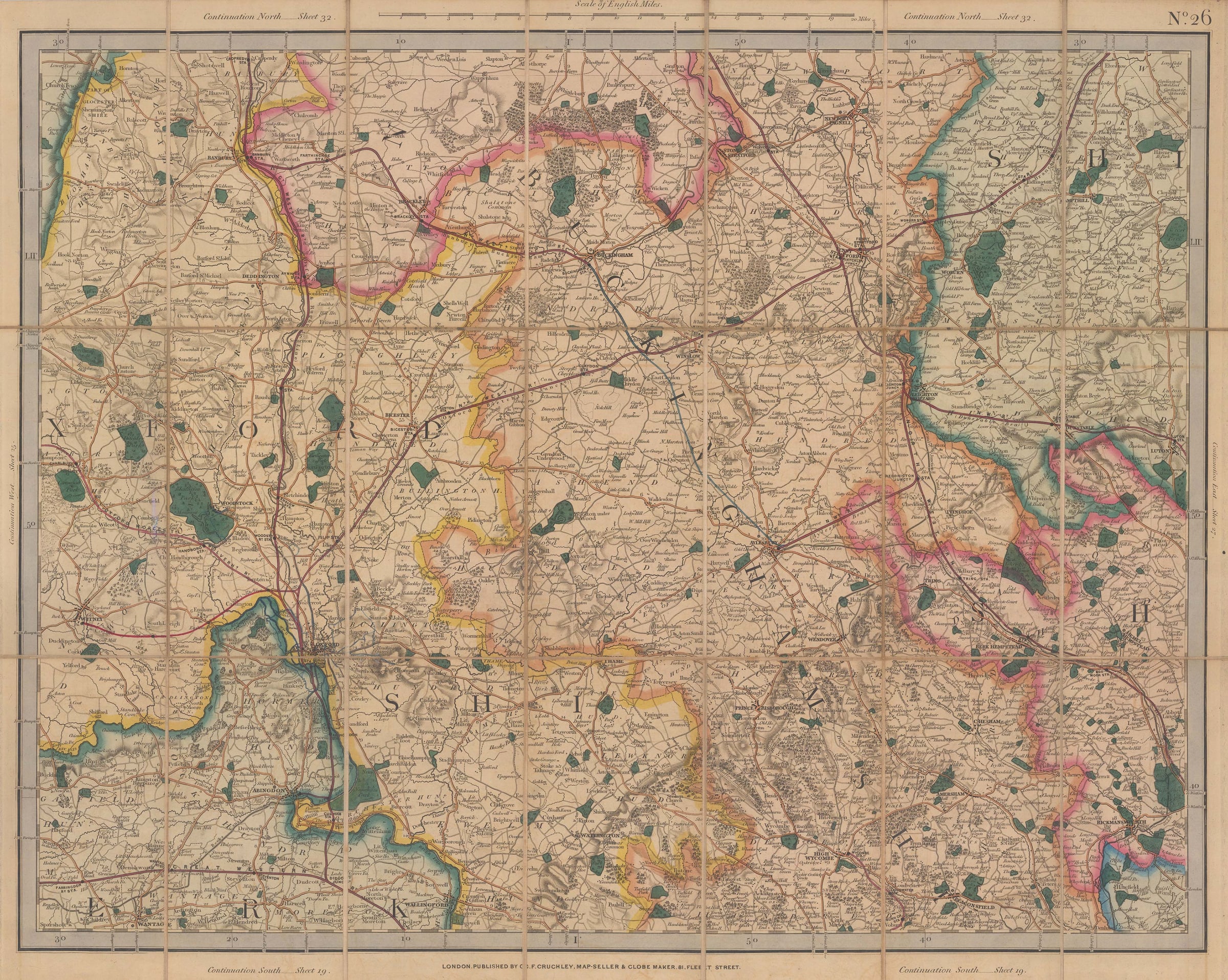
Cruchley's reduced Ordnance Survey map of Oxfordshire and Buckinghamshire on a scale of 2 miles to an inch. Major cities and towns shown on the map include Oxford, High Wycombe,...
Cruchley's reduced Ordnance Survey map of Oxfordshire and Buckinghamshire on a scale of 2 miles to an inch. Major cities and towns shown on the map include Oxford, High Wycombe, Aylesbury, Bicester, Abingdon, Banbury, Buckingham, Luton, Hemel Hempstead, Leighton Buzzard, and Woodstock. George Cruchley published his Reduced Ordnance Maps in direct competition with the Ordnance Survey's more detailed, but also more expensive maps of England & Wales. The clarity and attractive colour of Cruchley's maps also made them popular with the public.
Railways are marked on the map in pink, major roads are in orange, and enclosed parks and estates are coloured green. Though the map itself is undated, the manuscript addition of a railway line to Witney suggests an approximate date of 1860. The two stations between Witney and the mainline are unnamed and roughly located, suggesting that the line, which opened in 1861, was either very new or still under construction at the time this map was published.
Original colour. SL [OXON545]
Share
- Tumblr
Join our mailing list
* denotes required fields
We will process the personal data you have supplied to communicate with you in accordance with our Privacy Policy. You can unsubscribe or change your preferences at any time by clicking the link in our emails.
Contact
The Map House
54 Beauchamp Place,
London SW3 1NY,
United Kingdom
maps@themaphouse.com
+44 (0)20 7589 4325
![]()
Copyright © 2025 The Map House
This website uses cookies
This site uses cookies to help make it more useful to you. Please contact us to find out more about our Cookie Policy.