- All
- AFRICA
- ▪ Central Africa
- ▪ East Africa
- ▪ North Africa
- ▪ Southern Africa
- ▪ West Africa
- ▪ Atlantic Islands
- AMERICAS
-
▪ United States (USA)
- USA - East
- USA - Midwest
- USA - Northeast
- USA - Southeast
- USA - West & Southwest
- Alabama
- Alaska
- Arizona
- Arkansas
- California
- Colorado
- Connecticut
- Delaware
- Florida
- Georgia
- Hawaii
- Idaho
- Illinois
- Indiana
- Iowa
- Kansas
- Kentucky
- Louisiana
- Maine
- Maryland
- Massachusetts
- Michigan
- Minnesota
- Mississippi
- Missouri
- Montana
- Nebraska
- Nevada
- New Hampshire
- New Jersey
- New Mexico
- New York
- New York City
- North Carolina
- North Dakota
- Ohio
- Oklahoma
- Oregon
- Pennsylvania
- Rhode Island
- South Carolina
- South Dakota
- Tennessee
- Texas
- Utah
- Vermont
- Virginia
- Washington
- Washington, D.C.
- West Virginia
- Wisconsin
- Wyoming
- ▪ North America
- ▪ South America
- ▪ Caribbean
- ASIA
- ▪ East Asia
- ▪ Southeast Asia
- ▪ India & South Asia
- ▪ Middle East & Turkey
- BRITISH ISLES
- ▪ London
-
▪ England
- English Cities
- Bedfordshire
- Berkshire
- Buckinghamshire
- Cambridgeshire
- Cheshire
- Cornwall
- Cumbria
- Derbyshire
- Devon
- Dorset
- Durham
- Essex
- Gloucestershire
- Hampshire
- Herefordshire
- Hertfordshire
- Huntingdonshire
- Isle of Wight
- Kent
- Lancashire
- Leicestershire
- Lincolnshire
- Middlesex
- Norfolk
- Northamptonshire
- Northumberland
- Nottinghamshire
- Oxfordshire
- Rutland
- Shropshire
- Somerset
- Staffordshire
- Suffolk
- Surrey
- Sussex
- Warwickshire
- Wiltshire
- Worcestershire
- Yorkshire
- Yorkshire East Riding
- Yorkshire North Riding
- Yorkshire West Riding
- ▪ Ireland
- ▪ Scotland
- ▪ Wales
- EUROPE
- ▪ Austria & Switzerland
- ▪ Benelux Region
- ▪ Central & Eastern Europe
- ▪ France & Monaco
- ▪ Germany
- ▪ Greece
- ▪ Italy
- ▪ Mediterranean Sea
- ▪ Spain & Portugal
- ▪ Scandinavia & Baltics
- ▪ Russia, Ukraine & Caucasus
- OCEANIA
- ▪ Australia
- ▪ New Zealand
- ▪ Pacific Ocean & Islands
- ▪ Papua New Guinea
- POLAR
- CELESTIAL
- WORLD
- GLOBES & INSTRUMENTS
- THEMATIC
- COLLABORATIONS
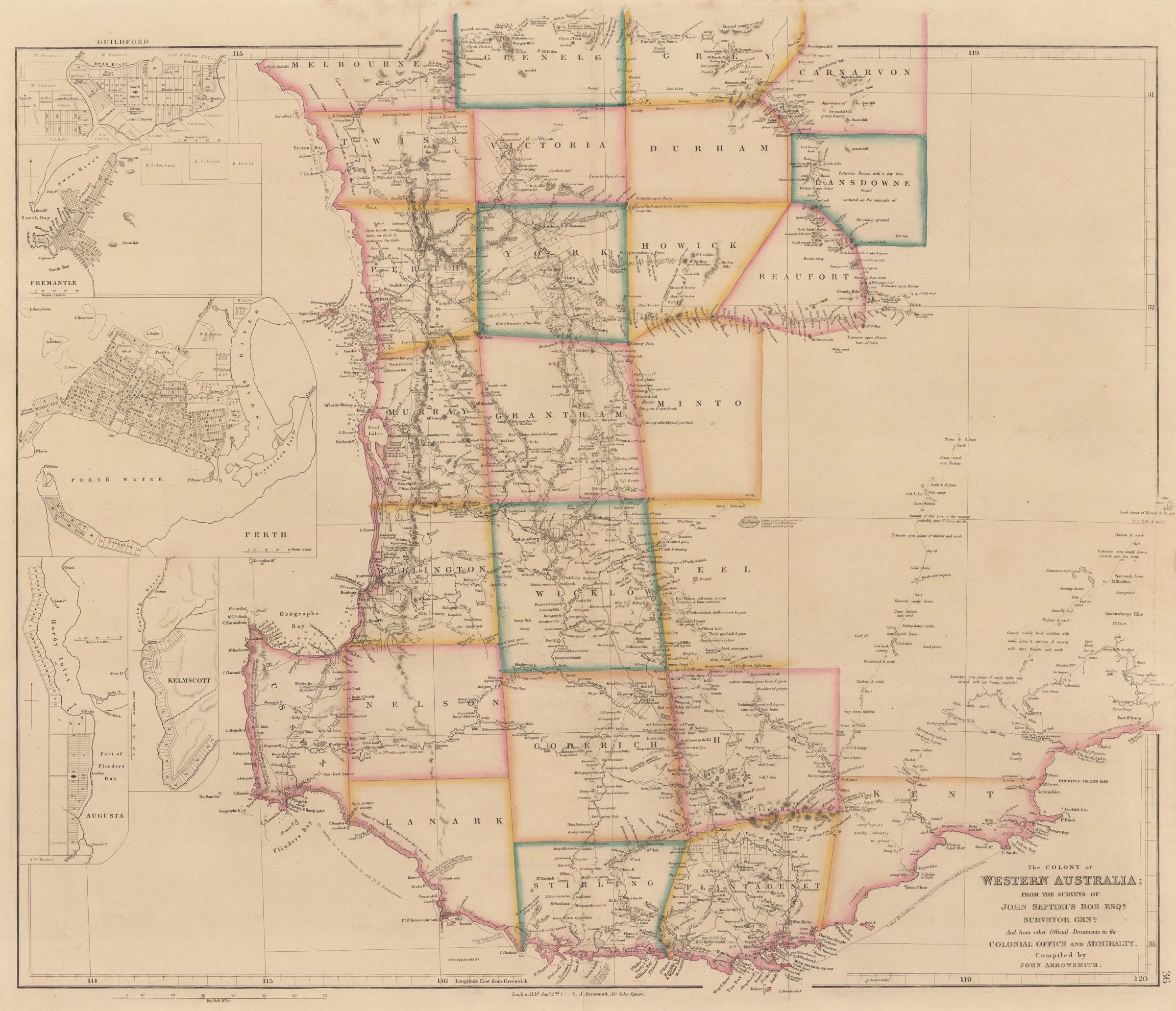
John Arrowsmith
52 x 62 cm
A hugely important and detailed map of Western Australia in its first state. Up to date geographic information was sourced from the Surveyor General, the Colonial Office, and the Admiralty.
John Arrowsmith (1790-1873)
John Arrowsmith, one of the greatest 19th-century English cartographers, was born in Winston, County Durham, in 1790. At the age of 20, John moved to London to join the prestigious mapmaking firm founded by his uncle, Aaron Arrowsmith. There, working alongside his cousins Aaron II and Samuel, he developed his expertise in engraving, lithography, globe-making, and publishing.
On the death of his uncle in 1823, John left the firm and decided to set up on his own; there is a suggestion that he became a dealer of prints and paintings in Paris between 1824 and 1826 but he must have returned to England shortly after as he was cited as one of the founders of the Royal Geographical Society in 1830. He became a highly influential member of the Society, acting as its unofficial cartographer for the next forty-three years and participating in its Council between 1851 and 1868; in 1863, he was awarded the Society’s Patron’s Medal. This position enabled him to access, engrave, and publish manuscript maps sent back to London by many of the foremost explorers of the age, including Burke & Wills, John Henning Speke, and David Livingstone.
Arrowsmith then obtained another powerful connection which gave him further privileged access to important manuscript maps: in 1837, he began to produce maps for Hansard, the firm charged with publishing Parliamentary reports and papers. Maps from the Colonial Office and the Honourable East India Co., among others, would first pass through Arrowsmith’s hands. This gave him an enormous advantage over his commercial rivals.
Arrowsmith’s own commercial enterprise culminated in the production of the “London Atlas of Universal Geography” first issued in 1834. As his prestige and contacts grew, so did the contents of this work. The importance of the above atlas cannot be overstated. There are maps dedicated to individuals whose names still resonate today. These include Captain Robert Fitzroy and the Officers of the Beagle, John Septimus Roe, first Surveyor General of Western Australia, and Lieut. Alexander Burnes, the legendary Burnes of Bokhara.
Original colour. [AUNZ2876]
- X
- Tumblr
Join our mailing list
* denotes required fields
We will process the personal data you have supplied to communicate with you in accordance with our Privacy Policy. You can unsubscribe or change your preferences at any time by clicking the link in our emails.
Contact
The Map House
54 Beauchamp Place,
London SW3 1NY,
United Kingdom
maps@themaphouse.com
+44 (0)20 7589 4325
![]()
This website uses cookies
This site uses cookies to help make it more useful to you. Please contact us to find out more about our Cookie Policy.
Join our mailing list
* denotes required fields
We will process the personal data you have supplied to communicate with you in accordance with our Privacy Policy. You can unsubscribe or change your preferences at any time by clicking the link in our emails.