- All
- AFRICA
- ▪ Central Africa
- ▪ East Africa
- ▪ North Africa
- ▪ Southern Africa
- ▪ West Africa
- ▪ Atlantic Islands
- AMERICAS
-
▪ United States (USA)
- USA - East
- USA - Midwest
- USA - Northeast
- USA - Southeast
- USA - West & Southwest
- Alabama
- Alaska
- Arizona
- Arkansas
- California
- Colorado
- Connecticut
- Delaware
- Florida
- Georgia
- Hawaii
- Idaho
- Illinois
- Indiana
- Iowa
- Kansas
- Kentucky
- Louisiana
- Maine
- Maryland
- Massachusetts
- Michigan
- Minnesota
- Mississippi
- Missouri
- Montana
- Nebraska
- Nevada
- New Hampshire
- New Jersey
- New Mexico
- New York
- New York City
- North Carolina
- North Dakota
- Ohio
- Oklahoma
- Oregon
- Pennsylvania
- Rhode Island
- South Carolina
- South Dakota
- Tennessee
- Texas
- Utah
- Vermont
- Virginia
- Washington
- Washington, D.C.
- West Virginia
- Wisconsin
- Wyoming
- ▪ North America
- ▪ South America
- ▪ Caribbean
- ASIA
- ▪ East Asia
- ▪ Southeast Asia
- ▪ India & South Asia
- ▪ Middle East & Turkey
- BRITISH ISLES
- ▪ London
-
▪ England
- English Cities
- Bedfordshire
- Berkshire
- Buckinghamshire
- Cambridgeshire
- Cheshire
- Cornwall
- Cumbria
- Derbyshire
- Devon
- Dorset
- Durham
- Essex
- Gloucestershire
- Hampshire
- Herefordshire
- Hertfordshire
- Huntingdonshire
- Isle of Wight
- Kent
- Lancashire
- Leicestershire
- Lincolnshire
- Middlesex
- Norfolk
- Northamptonshire
- Northumberland
- Nottinghamshire
- Oxfordshire
- Rutland
- Shropshire
- Somerset
- Staffordshire
- Suffolk
- Surrey
- Sussex
- Warwickshire
- Wiltshire
- Worcestershire
- Yorkshire
- Yorkshire East Riding
- Yorkshire North Riding
- Yorkshire West Riding
- ▪ Ireland
- ▪ Scotland
- ▪ Wales
- EUROPE
- ▪ Austria & Switzerland
- ▪ Benelux Region
- ▪ Central & Eastern Europe
- ▪ France & Monaco
- ▪ Germany
- ▪ Greece
- ▪ Italy
- ▪ Mediterranean Sea
- ▪ Spain & Portugal
- ▪ Scandinavia & Baltics
- ▪ Russia, Ukraine & Caucasus
- OCEANIA
- ▪ Australia
- ▪ New Zealand
- ▪ Pacific Ocean & Islands
- ▪ Papua New Guinea
- POLAR
- CELESTIAL
- WORLD
- GLOBES & INSTRUMENTS
- THEMATIC
- COLLABORATIONS
Henry Jay MacMillan
17 ½ x 27 in
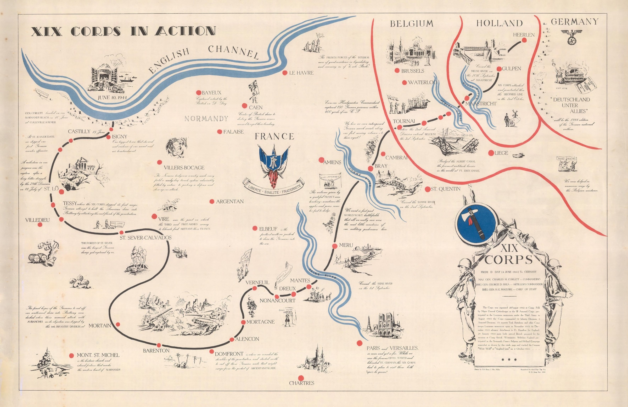
The route starts as the troops land on the beaches of Normandy where they saw action on 10th June 1944, and march through to Germany, marking that they penetrated the Siegfried Line on the 2nd October 1944. (The Siegfried Line was a defensive chain of fortifications built by the Germans along the western German border to France and Holland).
Across the map are annotations and illustrations briefly describing some the action seen by they XIX Corps, the military milestones they achieved and even the prisoners caught. Occasionally there is a touching comment about the local people they met and how welcoming they were, and famous landmarks they saw along their journey and those they did not get chance to see - "Paris and Versailles, so near and yet so far... had to plan to visit them both après la guerre". In Germany, alongside a vignette titled the "Last Acte", it claims the 1944 edition of the German national anthem will be "Deutschland unter Allies".
This map would have originally been issued as part of a pair in special editions of a corps publication called, "Le Tomahawk", which can be seen from the reverse of the map, with the title "XIX Corps Crack the Siegfried Line".
It was drawn by Henry Jay MacMillan (1908-1991) and printed by 62nd Engineer Topographic Company. MacMillan joined the United States Army in August 1942 and initially served in North Africa and Sicily. Following the landings in Normandy, Colonel Thomas Crystal saw that MacMillan was a talented artist and requested that he stay on to document military activities. He was assigned to follow the movement of the XIX Corps as they progressed through France, Belgium, Holland, and into Germany. He ended his journey in Barby in April 1945.
In Professor Susan Schulten's book "The History of America in 100 Maps" she states: "On both maps, MacMillan depicted the individual encounters that so profoundly affected the millions of Americans serving in Europe".
Printed colour. Laid down on archival linen. Image of verso available on request. [EUR1493]
- X
- Tumblr
Join our mailing list
* denotes required fields
We will process the personal data you have supplied to communicate with you in accordance with our Privacy Policy. You can unsubscribe or change your preferences at any time by clicking the link in our emails.
Contact
The Map House
54 Beauchamp Place,
London SW3 1NY,
United Kingdom
maps@themaphouse.com
+44 (0)20 7589 4325
![]()
This website uses cookies
This site uses cookies to help make it more useful to you. Please contact us to find out more about our Cookie Policy.
Join our mailing list
* denotes required fields
We will process the personal data you have supplied to communicate with you in accordance with our Privacy Policy. You can unsubscribe or change your preferences at any time by clicking the link in our emails.