- All
- AFRICA
- ▪ Central Africa
- ▪ East Africa
- ▪ North Africa
- ▪ Southern Africa
- ▪ West Africa
- ▪ Atlantic Islands
- AMERICAS
-
▪ United States (USA)
- USA - East
- USA - Midwest
- USA - Northeast
- USA - Southeast
- USA - West & Southwest
- Alabama
- Alaska
- Arizona
- Arkansas
- California
- Colorado
- Connecticut
- Delaware
- Florida
- Georgia
- Hawaii
- Idaho
- Illinois
- Indiana
- Iowa
- Kansas
- Kentucky
- Louisiana
- Maine
- Maryland
- Massachusetts
- Michigan
- Minnesota
- Mississippi
- Missouri
- Montana
- Nebraska
- Nevada
- New Hampshire
- New Jersey
- New Mexico
- New York
- New York City
- North Carolina
- North Dakota
- Ohio
- Oklahoma
- Oregon
- Pennsylvania
- Rhode Island
- South Carolina
- South Dakota
- Tennessee
- Texas
- Utah
- Vermont
- Virginia
- Washington
- Washington, D.C.
- West Virginia
- Wisconsin
- Wyoming
- ▪ North America
- ▪ South America
- ▪ Caribbean
- ASIA
- ▪ East Asia
- ▪ Southeast Asia
- ▪ India & South Asia
- ▪ Middle East & Turkey
- BRITISH ISLES
- ▪ London
-
▪ England
- English Cities
- Bedfordshire
- Berkshire
- Buckinghamshire
- Cambridgeshire
- Cheshire
- Cornwall
- Cumbria
- Derbyshire
- Devon
- Dorset
- Durham
- Essex
- Gloucestershire
- Hampshire
- Herefordshire
- Hertfordshire
- Huntingdonshire
- Isle of Wight
- Kent
- Lancashire
- Leicestershire
- Lincolnshire
- Middlesex
- Norfolk
- Northamptonshire
- Northumberland
- Nottinghamshire
- Oxfordshire
- Rutland
- Shropshire
- Somerset
- Staffordshire
- Suffolk
- Surrey
- Sussex
- Warwickshire
- Wiltshire
- Worcestershire
- Yorkshire
- Yorkshire East Riding
- Yorkshire North Riding
- Yorkshire West Riding
- ▪ Ireland
- ▪ Scotland
- ▪ Wales
- EUROPE
- ▪ Austria & Switzerland
- ▪ Benelux Region
- ▪ Central & Eastern Europe
- ▪ France & Monaco
- ▪ Germany
- ▪ Greece
- ▪ Italy
- ▪ Mediterranean Sea
- ▪ Spain & Portugal
- ▪ Scandinavia & Baltics
- ▪ Russia, Ukraine & Caucasus
- OCEANIA
- ▪ Australia
- ▪ New Zealand
- ▪ Pacific Ocean & Islands
- ▪ Papua New Guinea
- POLAR
- CELESTIAL
- WORLD
- GLOBES & INSTRUMENTS
- THEMATIC
- COLLABORATIONS
ONT Carpati
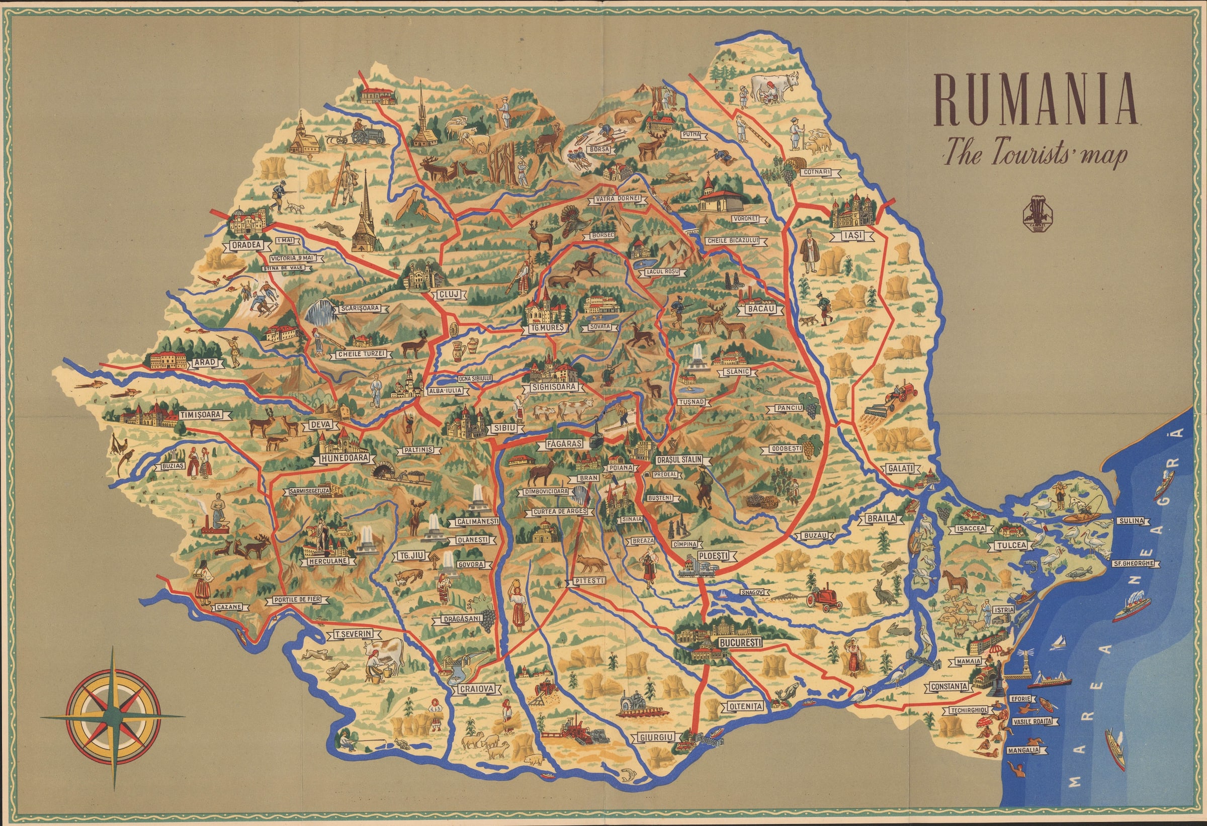
Vintage tourist map of Romania, 1950 c.
16 x 23 in
40 x 59 cm
40 x 59 cm
CEU2255
£ 295.00
ONT Carpati, Vintage tourist map of Romania, 1950 c.
Sold
%3Cdiv%20class%3D%22artist%22%3EONT%20Carpati%3C/div%3E%3Cdiv%20class%3D%22title_and_year%22%3E%3Cspan%20class%3D%22title_and_year_title%22%3EVintage%20tourist%20map%20of%20Romania%3C/span%3E%2C%20%3Cspan%20class%3D%22title_and_year_year%22%3E1950%20c.%3C/span%3E%3C/div%3E%3Cdiv%20class%3D%22dimensions%22%3E16%20x%2023%20in%3Cbr/%3E%0A40%20x%2059%20cm%3C/div%3E
Rumania The Tourists' Map Delightful vintage tourist map of Romania illustrating the country's scenery, culture, and tourist sites. Published by the Romanian National Tourist Office (ONT Carpati) to attract...
Rumania The Tourists' Map
Delightful vintage tourist map of Romania illustrating the country's scenery, culture, and tourist sites. Published by the Romanian National Tourist Office (ONT Carpati) to attract English-speaking visitors. On the back of the map is a lengthy description, in English, of the country's history, landscape, and its most important tourist resorts.
Though undated, the inclusion of affiliate tourist bureaus in both East and West Germany and the use of the name "Orașul Stalin" for the town of Brașov, suggest a publication date of c.1949-1960. The ONT was originally founded as a private consortium of hotels, but it was nationalised in 1948 under the Communist government. This map provides a fascinating and uncommon record of how the Communist government of Romania wished to be seen by the Western world.
Printed colour. [CEU2255]
Share
- Tumblr
Join our mailing list
* denotes required fields
We will process the personal data you have supplied to communicate with you in accordance with our Privacy Policy. You can unsubscribe or change your preferences at any time by clicking the link in our emails.
Contact
The Map House
54 Beauchamp Place,
London SW3 1NY,
United Kingdom
maps@themaphouse.com
+44 (0)20 7589 4325
![]()
Copyright © 2025 The Map House
This website uses cookies
This site uses cookies to help make it more useful to you. Please contact us to find out more about our Cookie Policy.