- All
- AFRICA
- ▪ Central Africa
- ▪ East Africa
- ▪ North Africa
- ▪ Southern Africa
- ▪ West Africa
- ▪ Atlantic Islands
- AMERICAS
-
▪ United States (USA)
- USA - East
- USA - Midwest
- USA - Northeast
- USA - Southeast
- USA - West & Southwest
- Alabama
- Alaska
- Arizona
- Arkansas
- California
- Colorado
- Connecticut
- Delaware
- Florida
- Georgia
- Hawaii
- Idaho
- Illinois
- Indiana
- Iowa
- Kansas
- Kentucky
- Louisiana
- Maine
- Maryland
- Massachusetts
- Michigan
- Minnesota
- Mississippi
- Missouri
- Montana
- Nebraska
- Nevada
- New Hampshire
- New Jersey
- New Mexico
- New York
- New York City
- North Carolina
- North Dakota
- Ohio
- Oklahoma
- Oregon
- Pennsylvania
- Rhode Island
- South Carolina
- South Dakota
- Tennessee
- Texas
- Utah
- Vermont
- Virginia
- Washington
- Washington, D.C.
- West Virginia
- Wisconsin
- Wyoming
- ▪ North America
- ▪ South America
- ▪ Caribbean
- ASIA
- ▪ East Asia
- ▪ Southeast Asia
- ▪ India & South Asia
- ▪ Middle East & Turkey
- BRITISH ISLES
- ▪ London
-
▪ England
- English Cities
- Bedfordshire
- Berkshire
- Buckinghamshire
- Cambridgeshire
- Cheshire
- Cornwall
- Cumbria
- Derbyshire
- Devon
- Dorset
- Durham
- Essex
- Gloucestershire
- Hampshire
- Herefordshire
- Hertfordshire
- Huntingdonshire
- Isle of Wight
- Kent
- Lancashire
- Leicestershire
- Lincolnshire
- Middlesex
- Norfolk
- Northamptonshire
- Northumberland
- Nottinghamshire
- Oxfordshire
- Rutland
- Shropshire
- Somerset
- Staffordshire
- Suffolk
- Surrey
- Sussex
- Warwickshire
- Wiltshire
- Worcestershire
- Yorkshire
- Yorkshire East Riding
- Yorkshire North Riding
- Yorkshire West Riding
- ▪ Ireland
- ▪ Scotland
- ▪ Wales
- EUROPE
- ▪ Austria & Switzerland
- ▪ Benelux Region
- ▪ Central & Eastern Europe
- ▪ France & Monaco
- ▪ Germany
- ▪ Greece
- ▪ Italy
- ▪ Mediterranean Sea
- ▪ Spain & Portugal
- ▪ Scandinavia & Baltics
- ▪ Russia, Ukraine & Caucasus
- OCEANIA
- ▪ Australia
- ▪ New Zealand
- ▪ Pacific Ocean & Islands
- ▪ Papua New Guinea
- POLAR
- CELESTIAL
- WORLD
- GLOBES & INSTRUMENTS
- THEMATIC
- COLLABORATIONS
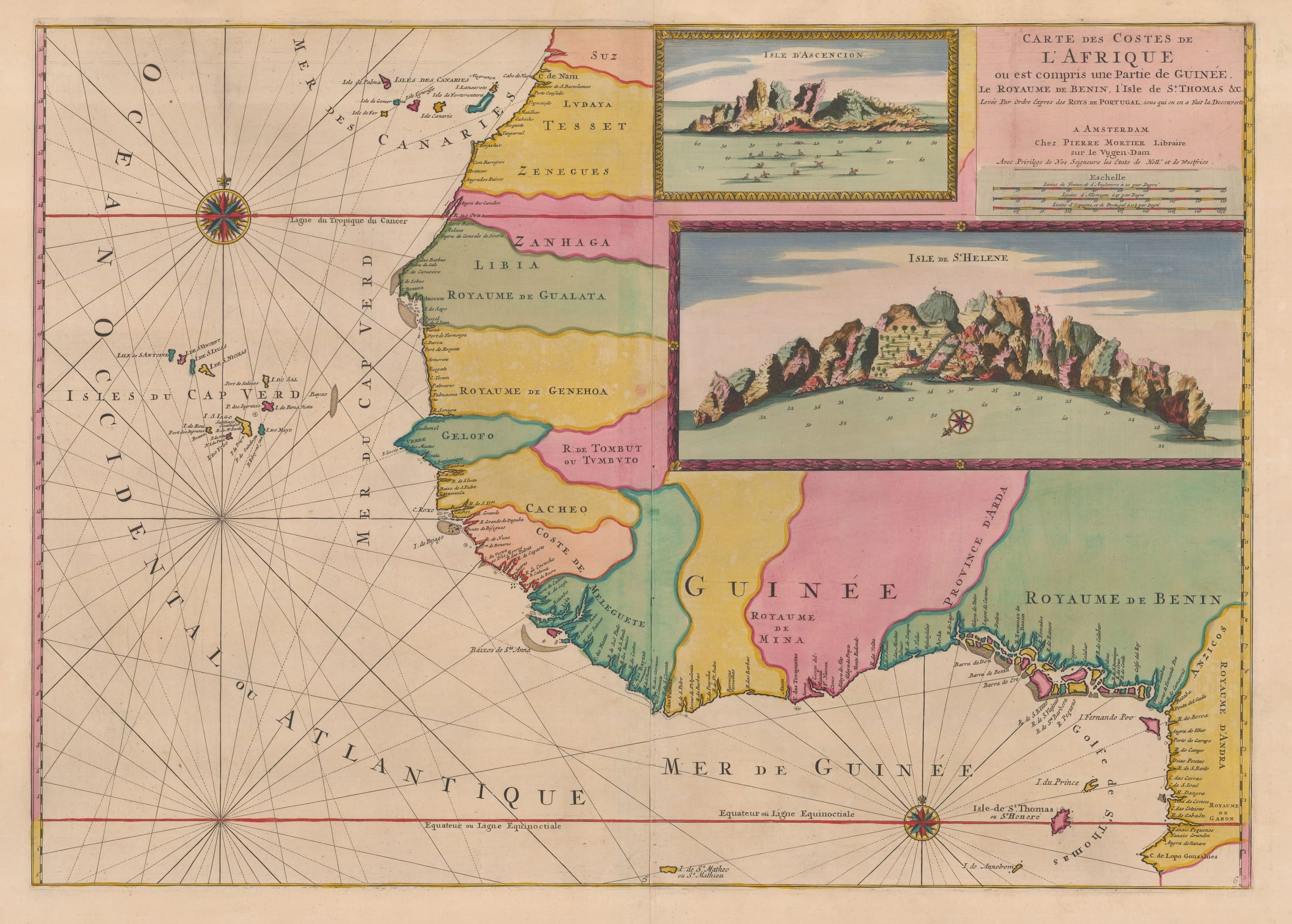
Pierre Mortier
54 x 77 cm
Beautiful example of Mortier's chart focusing on western Africa from the modern nation of Western Sahara to the Cameroon, including the Canaries and the Cape Verde Islands.
Typically flamboyant, this chart covers the west African coast. Among the coastlines it covers are Nigeria, Benin, Sierra Leone, Ghana, Cameroon, Senegal and Cote d'Ivoire. The map also shows the relative position of the Canary Islands and the Cape Verde Islands to the coast.
As with all of Mortier's charts of Africa, the geographical source were the manuscript surveys copied by a French diplomat in the court of the King of Portugal Pedro II. This also accounts for the two large insets adorning the upper right quarter of the map, one showing a fanciful coastal profile of Santa Helena and the other of Ascension Island. These were both Portuguese discoveries in the far South Atlantic in the early 16th century, hence their inclusion on this map.
The "Neptune Francois" was first issued simultaneously in Paris and Amsterdam by Hubert Jaillot and Pierre Mortier respectively in 1693. The project was highly successful and Mortier developed the Atlas by adding two more sections or volumes to it. The first, Vol II was also issued in 1693 and consisted of a set of charts provided by the noted Dutch artist Romeyn de Hooghe. Collectively these are known as the "Cartes Marines a l'Usage des Armees du Roy de Grande Bretagne" and were originally drawn for William III of Great Britain. De Hooghe was primarily an artist and his charts bear a distinctive pictorial aspect. They have become renowned for their aesthetics, being cited as the most beautiful set of charts ever published. Volume III added in 1700, entitled "Suite de Neptune" concentrated on charts outside of French territory, including maps of the New World, the West Indies, South East Asia and the Indian Ocean among others.
Mortier's edition was a prestige work. Later scholars have found that his book was the most expensive sea atlas produced in Amsterdam up to that time. On the rare occasions that an example of one of the maps in full original colour can be obtained, it is easily perceived why this work is cited as one of the finest and most spectacular atlases ever produced.
Magnificent original hand colour. [AFR6071] (BC)
- X
- Tumblr
Join our mailing list
* denotes required fields
We will process the personal data you have supplied to communicate with you in accordance with our Privacy Policy. You can unsubscribe or change your preferences at any time by clicking the link in our emails.
Contact
The Map House
54 Beauchamp Place,
London SW3 1NY,
United Kingdom
maps@themaphouse.com
+44 (0)20 7589 4325
![]()
This website uses cookies
This site uses cookies to help make it more useful to you. Please contact us to find out more about our Cookie Policy.
Join our mailing list
* denotes required fields
We will process the personal data you have supplied to communicate with you in accordance with our Privacy Policy. You can unsubscribe or change your preferences at any time by clicking the link in our emails.