- All
- AFRICA
- ▪ Central Africa
- ▪ East Africa
- ▪ North Africa
- ▪ Southern Africa
- ▪ West Africa
- ▪ Atlantic Islands
- AMERICAS
-
▪ United States (USA)
- USA - East
- USA - Midwest
- USA - Northeast
- USA - Southeast
- USA - West & Southwest
- Alabama
- Alaska
- Arizona
- Arkansas
- California
- Colorado
- Connecticut
- Delaware
- Florida
- Georgia
- Hawaii
- Idaho
- Illinois
- Indiana
- Iowa
- Kansas
- Kentucky
- Louisiana
- Maine
- Maryland
- Massachusetts
- Michigan
- Minnesota
- Mississippi
- Missouri
- Montana
- Nebraska
- Nevada
- New Hampshire
- New Jersey
- New Mexico
- New York
- New York City
- North Carolina
- North Dakota
- Ohio
- Oklahoma
- Oregon
- Pennsylvania
- Rhode Island
- South Carolina
- South Dakota
- Tennessee
- Texas
- Utah
- Vermont
- Virginia
- Washington
- Washington, D.C.
- West Virginia
- Wisconsin
- Wyoming
- ▪ North America
- ▪ South America
- ▪ Caribbean
- ASIA
- ▪ East Asia
- ▪ Southeast Asia
- ▪ India & South Asia
- ▪ Middle East & Turkey
- BRITISH ISLES
- ▪ London
-
▪ England
- English Cities
- Bedfordshire
- Berkshire
- Buckinghamshire
- Cambridgeshire
- Cheshire
- Cornwall
- Cumbria
- Derbyshire
- Devon
- Dorset
- Durham
- Essex
- Gloucestershire
- Hampshire
- Herefordshire
- Hertfordshire
- Huntingdonshire
- Isle of Wight
- Kent
- Lancashire
- Leicestershire
- Lincolnshire
- Middlesex
- Norfolk
- Northamptonshire
- Northumberland
- Nottinghamshire
- Oxfordshire
- Rutland
- Shropshire
- Somerset
- Staffordshire
- Suffolk
- Surrey
- Sussex
- Warwickshire
- Wiltshire
- Worcestershire
- Yorkshire
- Yorkshire East Riding
- Yorkshire North Riding
- Yorkshire West Riding
- ▪ Ireland
- ▪ Scotland
- ▪ Wales
- EUROPE
- ▪ Austria & Switzerland
- ▪ Benelux Region
- ▪ Central & Eastern Europe
- ▪ France & Monaco
- ▪ Germany
- ▪ Greece
- ▪ Italy
- ▪ Mediterranean Sea
- ▪ Spain & Portugal
- ▪ Scandinavia & Baltics
- ▪ Russia, Ukraine & Caucasus
- OCEANIA
- ▪ Australia
- ▪ New Zealand
- ▪ Pacific Ocean & Islands
- ▪ Papua New Guinea
- POLAR
- CELESTIAL
- WORLD
- GLOBES & INSTRUMENTS
- THEMATIC
- COLLABORATIONS
Pierre Mortier
Map of the Coasts of Africa, 1708
23 ½ x 19 ½ in
60 x 49 cm
60 x 49 cm
AFR6068
£ 1,750.00
Pierre Mortier, Map of the Coasts of Africa, 1708
Sold
%3Cdiv%20class%3D%22artist%22%3EPierre%20Mortier%3C/div%3E%3Cdiv%20class%3D%22title_and_year%22%3E%3Cspan%20class%3D%22title_and_year_title%22%3EMap%20of%20the%20Coasts%20of%20Africa%3C/span%3E%2C%20%3Cspan%20class%3D%22title_and_year_year%22%3E1708%3C/span%3E%3C/div%3E%3Cdiv%20class%3D%22dimensions%22%3E23%20%C2%BD%20x%2019%20%C2%BD%20in%3Cbr/%3E%0A60%20x%2049%20cm%3C/div%3E
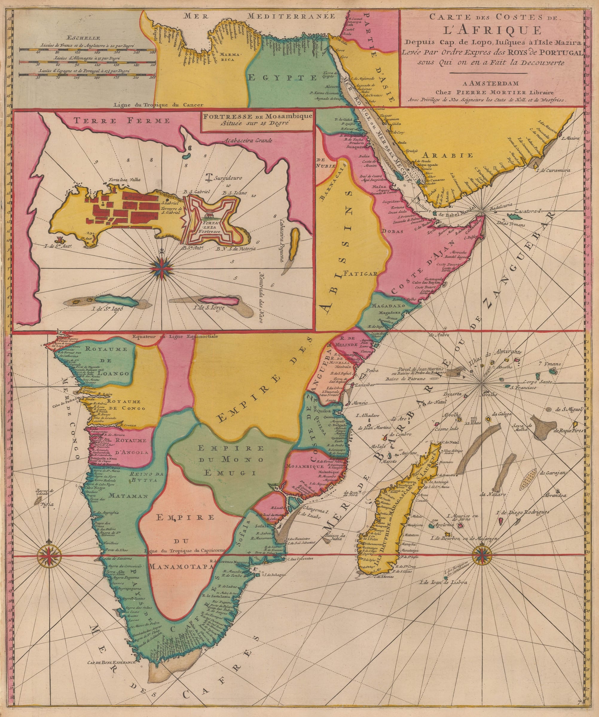
Carte des Costes de l'Afrique Beautiful example of Mortier's chart of the continent of Africa from the Kingdom of Loango, or modern Republic of Congo, on the west coast,...
Carte des Costes de l'Afrique
Beautiful example of Mortier's chart of the continent of Africa from the Kingdom of Loango, or modern Republic of Congo, on the west coast, past Southern Africa and then detailing the east coast, Red Sea and the southwestern Arabian Peninsula.
The sources for this map were Portuguese and the large inset shows a plan of the Fortress of Mozambique now renamed the Fortress of Maputo. This was the centre of Portuguese power on the south eastern coast of Africa.
The "Neptune Francois" was first issued simultaneously in Paris and Amsterdam by Hubert Jaillot and Pierre Mortier respectively in 1693. The project was highly successful and Mortier developed the Atlas by adding two more sections or volumes to it. The first, Vol II was also issued in 1693 and consisted of a set of charts provided by the noted Dutch artist Romeyn de Hooghe. Collectively these are known as the "Cartes Marines a l'Usage des Armees du Roy de Grande Bretagne" and were originally drawn for William III of Great Britain. De Hooghe was primarily an artist and his charts bear a distinctive pictorial aspect. They have become renowned for their aesthetics, being cited as the most beautiful set of charts ever published. Volume III added in 1700, entitled "Suite de Neptune" concentrated on charts outside of French territory, including maps of the New World, the West Indies, South East Asia and the Indian Ocean among others.
Mortier's edition was a prestige work. Later scholars have found that his book was the most expensive sea atlas produced in Amsterdam up to that time. On the rare occasions that an example of one of the maps in full original colour can be obtained, it is easily perceived why this work is cited as one of the finest and most spectacular atlases ever produced.
Magnificent original hand colour. [AFR6068]
Share
- Tumblr
Join our mailing list
* denotes required fields
We will process the personal data you have supplied to communicate with you in accordance with our Privacy Policy. You can unsubscribe or change your preferences at any time by clicking the link in our emails.
Contact
The Map House
54 Beauchamp Place,
London SW3 1NY,
United Kingdom
maps@themaphouse.com
+44 (0)20 7589 4325
![]()
Copyright © 2025 The Map House
This website uses cookies
This site uses cookies to help make it more useful to you. Please contact us to find out more about our Cookie Policy.