- All
- AFRICA
- ▪ Central Africa
- ▪ East Africa
- ▪ North Africa
- ▪ Southern Africa
- ▪ West Africa
- ▪ Atlantic Islands
- AMERICAS
-
▪ United States (USA)
- USA - East
- USA - Midwest
- USA - Northeast
- USA - Southeast
- USA - West & Southwest
- Alabama
- Alaska
- Arizona
- Arkansas
- California
- Colorado
- Connecticut
- Delaware
- Florida
- Georgia
- Hawaii
- Idaho
- Illinois
- Indiana
- Iowa
- Kansas
- Kentucky
- Louisiana
- Maine
- Maryland
- Massachusetts
- Michigan
- Minnesota
- Mississippi
- Missouri
- Montana
- Nebraska
- Nevada
- New Hampshire
- New Jersey
- New Mexico
- New York
- New York City
- North Carolina
- North Dakota
- Ohio
- Oklahoma
- Oregon
- Pennsylvania
- Rhode Island
- South Carolina
- South Dakota
- Tennessee
- Texas
- Utah
- Vermont
- Virginia
- Washington
- Washington, D.C.
- West Virginia
- Wisconsin
- Wyoming
- ▪ North America
- ▪ South America
- ▪ Caribbean
- ASIA
- ▪ East Asia
- ▪ Southeast Asia
- ▪ India & South Asia
- ▪ Middle East & Turkey
- BRITISH ISLES
- ▪ London
-
▪ England
- English Cities
- Bedfordshire
- Berkshire
- Buckinghamshire
- Cambridgeshire
- Cheshire
- Cornwall
- Cumbria
- Derbyshire
- Devon
- Dorset
- Durham
- Essex
- Gloucestershire
- Hampshire
- Herefordshire
- Hertfordshire
- Huntingdonshire
- Isle of Wight
- Kent
- Lancashire
- Leicestershire
- Lincolnshire
- Middlesex
- Norfolk
- Northamptonshire
- Northumberland
- Nottinghamshire
- Oxfordshire
- Rutland
- Shropshire
- Somerset
- Staffordshire
- Suffolk
- Surrey
- Sussex
- Warwickshire
- Wiltshire
- Worcestershire
- Yorkshire
- Yorkshire East Riding
- Yorkshire North Riding
- Yorkshire West Riding
- ▪ Ireland
- ▪ Scotland
- ▪ Wales
- EUROPE
- ▪ Austria & Switzerland
- ▪ Benelux Region
- ▪ Central & Eastern Europe
- ▪ France & Monaco
- ▪ Germany
- ▪ Greece
- ▪ Italy
- ▪ Mediterranean Sea
- ▪ Spain & Portugal
- ▪ Scandinavia & Baltics
- ▪ Russia, Ukraine & Caucasus
- OCEANIA
- ▪ Australia
- ▪ New Zealand
- ▪ Pacific Ocean & Islands
- ▪ Papua New Guinea
- POLAR
- CELESTIAL
- WORLD
- GLOBES & INSTRUMENTS
- THEMATIC
- COLLABORATIONS
British Admiralty
98 x 64 cm
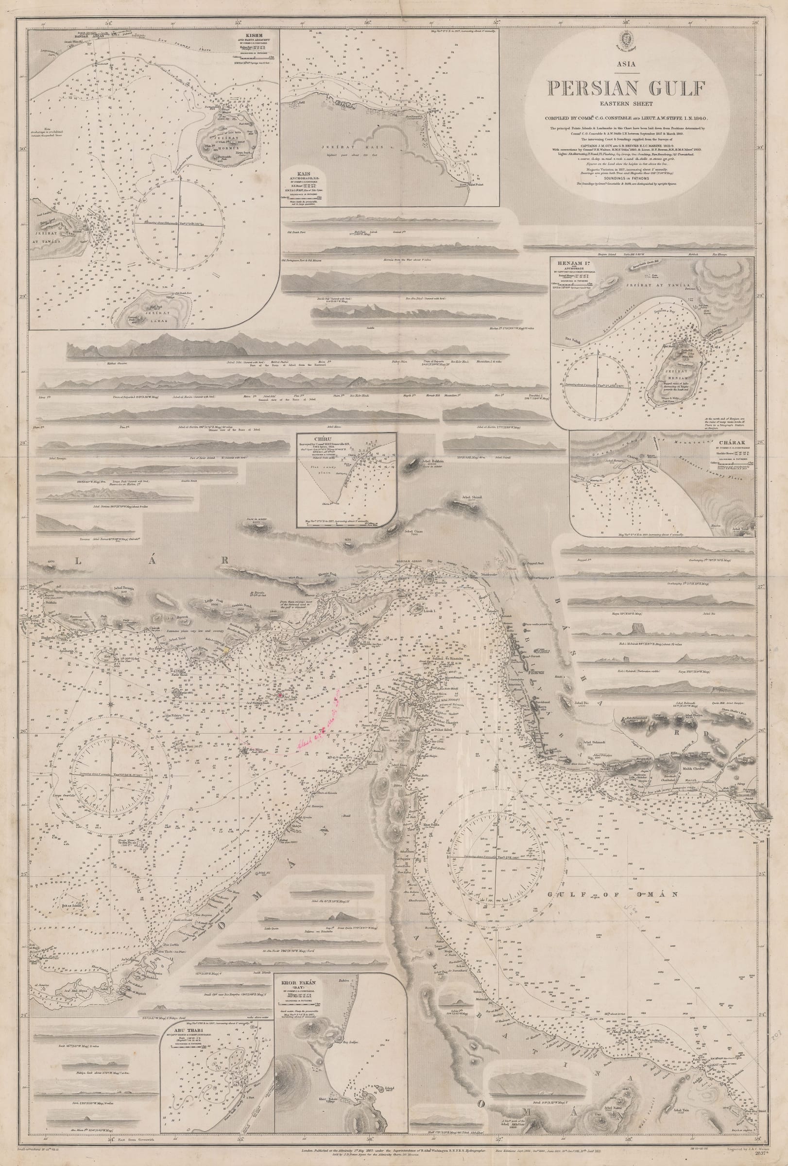
This is the eastern sheet of the foundational survey of the Gulf based on the work of Comm. G. C. Constable and Lieut. A. W. Stiffe in 1857-60. These were two career officers of the Indian Navy. Constable had already made his mark in 1850, with a lecture to the Bombay Geographical Society, outlining the problems presented by the lack of a recent survey of the Gulf. The last major chart of the waterway was based on the survey of Lieuts. Guy and Bruckes of the Bombay Marine in 1821-9; although ground-breaking in its time, both marine and surveying technology had advanced drastically during in the intervening years and the need for a new survey was paramount.
In 1856, Constable was attached to the forces participating in the First Anglo-Persian War and by its conclusion in 1857, he was detached with instructions to make a new survey of the Gulf. He was joined in this endeavour by Lieut. A. W. Stiffe and over the next three years, these officers would produce what is now considered to be one of the two foundational navigation surveys of the Gulf. Constable and Stiffe became renowned for the painstaking detail of their overall and regional charts, integrating local sources with their own work. Contemporary accounts describe the meticulous working methods of the officers as well as multiple visits to towns along the Gulf and Persian coasts to consult local dignitaries and merchants about the nearby shores and waters.
The result was a survey that was used decades as a paradigm upon which further marine surveys were revised and refined. Geographically, this sheet focuses on the modern United Arab Emirates, Oman and the southern Iranian coast. The painstaking detail is clearly obvious; multiple coastal profiles are pictured on the map together with seven inset maps of specific anchorages, including Abu Dhabi, (Abu Thabi on the map), Khor Fakkan in the Emirates as well as Hormuz and Hengam Islands on the coast of Iran. Extraordinary detail is shown on the coast including Dubai, Sharja and Abu Dhabi, now correctly shown at the head of a small inlet. This detail is also shown on the coast of Oman, from Muskat to the tip of eastern Arabia. A faint manuscript note and circle notes the presence and range of a lighthouse situated on the disputed island of Great Tunb.
The cartouche refers to the compilers of this survey as Constable and Stiffe; there is a reference to the earlier survey by Guy and Bruckes as well as a credit to further corrections by Comm. F. H. Owen of H.M.S. Odin in 1910 and Lieut. H. T. Bowen of H.M.S. Alert in the same year. The lower left shows small corrections to 1912.
Although this survey was the foundation survey for the Gulf for such a long time, this chart is extremely rare commercially; the British Library cites an example in its collection from 1951 while the National Library of Qatar cites a digital example of 1933 where the original was sourced again from the British Library.
[MEAST4404]
- X
- Tumblr
Join our mailing list
* denotes required fields
We will process the personal data you have supplied to communicate with you in accordance with our Privacy Policy. You can unsubscribe or change your preferences at any time by clicking the link in our emails.
Contact
The Map House
54 Beauchamp Place,
London SW3 1NY,
United Kingdom
maps@themaphouse.com
+44 (0)20 7589 4325
![]()
This website uses cookies
This site uses cookies to help make it more useful to you. Please contact us to find out more about our Cookie Policy.
Join our mailing list
* denotes required fields
We will process the personal data you have supplied to communicate with you in accordance with our Privacy Policy. You can unsubscribe or change your preferences at any time by clicking the link in our emails.