- All
- AFRICA
- ▪ Central Africa
- ▪ East Africa
- ▪ North Africa
- ▪ Southern Africa
- ▪ West Africa
- ▪ Atlantic Islands
- AMERICAS
-
▪ United States (USA)
- USA - East
- USA - Midwest
- USA - Northeast
- USA - Southeast
- USA - West & Southwest
- Alabama
- Alaska
- Arizona
- Arkansas
- California
- Colorado
- Connecticut
- Delaware
- Florida
- Georgia
- Hawaii
- Idaho
- Illinois
- Indiana
- Iowa
- Kansas
- Kentucky
- Louisiana
- Maine
- Maryland
- Massachusetts
- Michigan
- Minnesota
- Mississippi
- Missouri
- Montana
- Nebraska
- Nevada
- New Hampshire
- New Jersey
- New Mexico
- New York
- New York City
- North Carolina
- North Dakota
- Ohio
- Oklahoma
- Oregon
- Pennsylvania
- Rhode Island
- South Carolina
- South Dakota
- Tennessee
- Texas
- Utah
- Vermont
- Virginia
- Washington
- Washington, D.C.
- West Virginia
- Wisconsin
- Wyoming
- ▪ North America
- ▪ South America
- ▪ Caribbean
- ASIA
- ▪ East Asia
- ▪ Southeast Asia
- ▪ India & South Asia
- ▪ Middle East & Turkey
- BRITISH ISLES
- ▪ London
-
▪ England
- English Cities
- Bedfordshire
- Berkshire
- Buckinghamshire
- Cambridgeshire
- Cheshire
- Cornwall
- Cumbria
- Derbyshire
- Devon
- Dorset
- Durham
- Essex
- Gloucestershire
- Hampshire
- Herefordshire
- Hertfordshire
- Huntingdonshire
- Isle of Wight
- Kent
- Lancashire
- Leicestershire
- Lincolnshire
- Middlesex
- Norfolk
- Northamptonshire
- Northumberland
- Nottinghamshire
- Oxfordshire
- Rutland
- Shropshire
- Somerset
- Staffordshire
- Suffolk
- Surrey
- Sussex
- Warwickshire
- Wiltshire
- Worcestershire
- Yorkshire
- Yorkshire East Riding
- Yorkshire North Riding
- Yorkshire West Riding
- ▪ Ireland
- ▪ Scotland
- ▪ Wales
- EUROPE
- ▪ Austria & Switzerland
- ▪ Benelux Region
- ▪ Central & Eastern Europe
- ▪ France & Monaco
- ▪ Germany
- ▪ Greece
- ▪ Italy
- ▪ Mediterranean Sea
- ▪ Spain & Portugal
- ▪ Scandinavia & Baltics
- ▪ Russia, Ukraine & Caucasus
- OCEANIA
- ▪ Australia
- ▪ New Zealand
- ▪ Pacific Ocean & Islands
- ▪ Papua New Guinea
- POLAR
- CELESTIAL
- WORLD
- GLOBES & INSTRUMENTS
- THEMATIC
- COLLABORATIONS
Luftwaffe
WW2-era map of Minsk, 1941 c.
30 1/2 x 26 1/2 in
78 x 67 cm
78 x 67 cm
RUS2606
£ 595.00
Luftwaffe, WW2-era map of Minsk, 1941 c.
Sold
%3Cdiv%20class%3D%22artist%22%3ELuftwaffe%3C/div%3E%3Cdiv%20class%3D%22title_and_year%22%3E%3Cspan%20class%3D%22title_and_year_title%22%3EWW2-era%20map%20of%20Minsk%3C/span%3E%2C%20%3Cspan%20class%3D%22title_and_year_year%22%3E1941%20c.%3C/span%3E%3C/div%3E%3Cdiv%20class%3D%22dimensions%22%3E30%201/2%20x%2026%201/2%20in%3Cbr/%3E%0A78%20x%2067%20cm%3C/div%3E
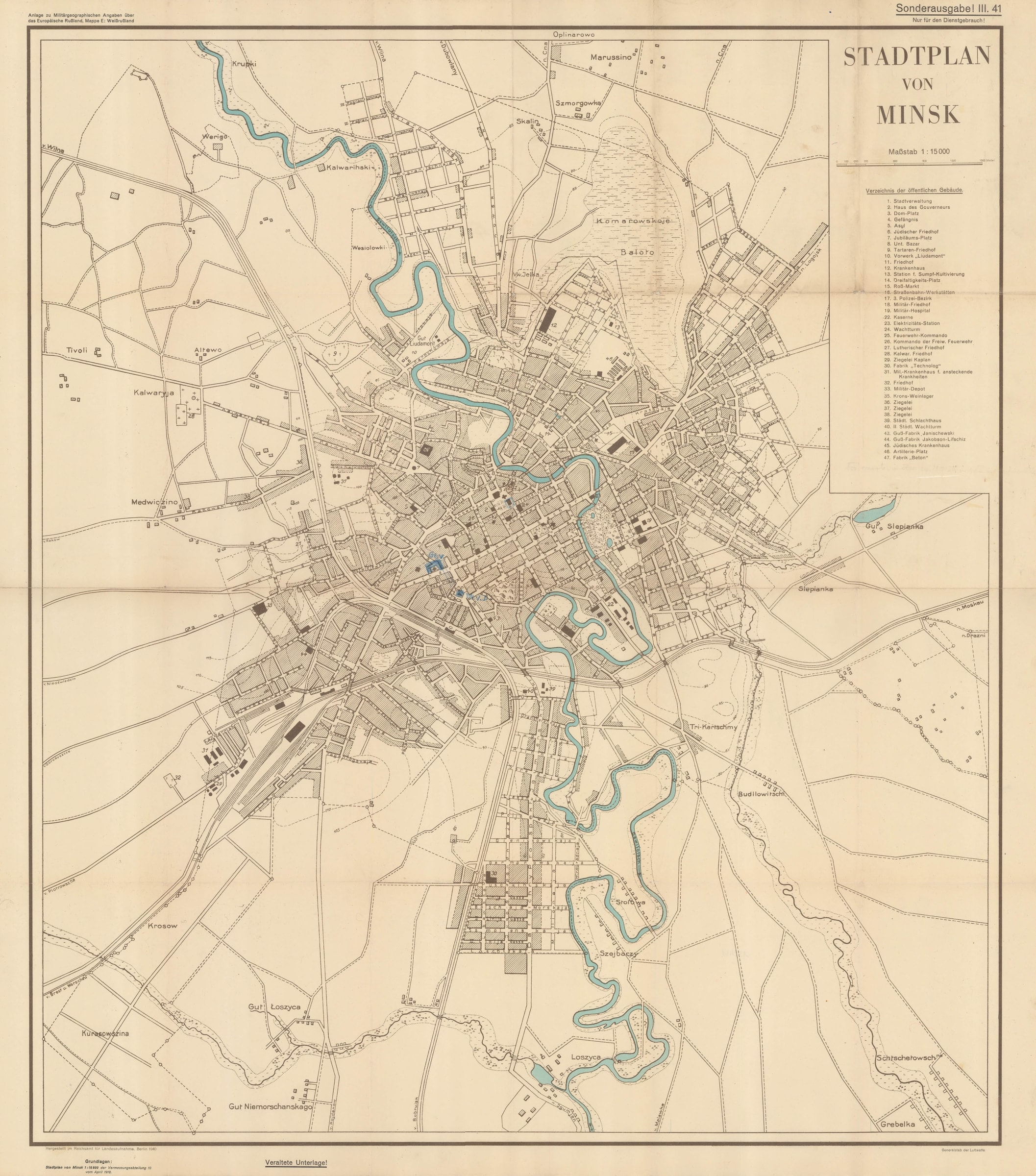
Stadtplan von Minsk Large, WW2-era map of Minsk, Belarus, published by the German Air Force (Luftwaffe) for military use. An index of important public buildings is included in the...
Stadtplan von Minsk
Large, WW2-era map of Minsk, Belarus, published by the German Air Force (Luftwaffe) for military use. An index of important public buildings is included in the upper-right corner. These buildings are also marked out in black on the map. The map is identified as "Sonderausgabe! III.41" in the upper-right corner, suggesting that this 'Special Edition' was published in 1941, rather than 1940 as the imprint in the lower-left corner would suggest. We can also see from the lower-left corner that the source of this extremely detailed map was a earlier map of April, 1918, surveyed during the final German offensive on the Eastern Front of WW1.
A later manuscript hand has marked three buildings in blue pencil: the government building of Belarus [marked 'Gov'], the headquarters of the N.K.V.D., the Soviet Union's ruthless state security agency, [marked 'NKVD'], and a third building which is not labeled, but which was also operated by the N.K.V.D. This map, therefore, relates both to WW2 and the Cold War, and serves as a fascinating record of 20th century Minsk.
Printed colour. [RUS2606]
Share
- Tumblr
Join our mailing list
* denotes required fields
We will process the personal data you have supplied to communicate with you in accordance with our Privacy Policy. You can unsubscribe or change your preferences at any time by clicking the link in our emails.
Contact
The Map House
54 Beauchamp Place,
London SW3 1NY,
United Kingdom
maps@themaphouse.com
+44 (0)20 7589 4325
![]()
Copyright © 2025 The Map House
This website uses cookies
This site uses cookies to help make it more useful to you. Please contact us to find out more about our Cookie Policy.