- All
- AFRICA
- ▪ Central Africa
- ▪ East Africa
- ▪ North Africa
- ▪ Southern Africa
- ▪ West Africa
- ▪ Atlantic Islands
- AMERICAS
-
▪ United States (USA)
- USA - East
- USA - Midwest
- USA - Northeast
- USA - Southeast
- USA - West & Southwest
- Alabama
- Alaska
- Arizona
- Arkansas
- California
- Colorado
- Connecticut
- Delaware
- Florida
- Georgia
- Hawaii
- Idaho
- Illinois
- Indiana
- Iowa
- Kansas
- Kentucky
- Louisiana
- Maine
- Maryland
- Massachusetts
- Michigan
- Minnesota
- Mississippi
- Missouri
- Montana
- Nebraska
- Nevada
- New Hampshire
- New Jersey
- New Mexico
- New York
- New York City
- North Carolina
- North Dakota
- Ohio
- Oklahoma
- Oregon
- Pennsylvania
- Rhode Island
- South Carolina
- South Dakota
- Tennessee
- Texas
- Utah
- Vermont
- Virginia
- Washington
- Washington, D.C.
- West Virginia
- Wisconsin
- Wyoming
- ▪ North America
- ▪ South America
- ▪ Caribbean
- ASIA
- ▪ East Asia
- ▪ Southeast Asia
- ▪ India & South Asia
- ▪ Middle East & Turkey
- BRITISH ISLES
- ▪ London
-
▪ England
- English Cities
- Bedfordshire
- Berkshire
- Buckinghamshire
- Cambridgeshire
- Cheshire
- Cornwall
- Cumbria
- Derbyshire
- Devon
- Dorset
- Durham
- Essex
- Gloucestershire
- Hampshire
- Herefordshire
- Hertfordshire
- Huntingdonshire
- Isle of Wight
- Kent
- Lancashire
- Leicestershire
- Lincolnshire
- Middlesex
- Norfolk
- Northamptonshire
- Northumberland
- Nottinghamshire
- Oxfordshire
- Rutland
- Shropshire
- Somerset
- Staffordshire
- Suffolk
- Surrey
- Sussex
- Warwickshire
- Wiltshire
- Worcestershire
- Yorkshire
- Yorkshire East Riding
- Yorkshire North Riding
- Yorkshire West Riding
- ▪ Ireland
- ▪ Scotland
- ▪ Wales
- EUROPE
- ▪ Austria & Switzerland
- ▪ Benelux Region
- ▪ Central & Eastern Europe
- ▪ France & Monaco
- ▪ Germany
- ▪ Greece
- ▪ Italy
- ▪ Mediterranean Sea
- ▪ Spain & Portugal
- ▪ Scandinavia & Baltics
- ▪ Russia, Ukraine & Caucasus
- OCEANIA
- ▪ Australia
- ▪ New Zealand
- ▪ Pacific Ocean & Islands
- ▪ Papua New Guinea
- POLAR
- CELESTIAL
- WORLD
- GLOBES & INSTRUMENTS
- THEMATIC
- COLLABORATIONS
Pierre Mortier
South Carolina, 1700
19 ½ x 24 in
49 x 61 cm
49 x 61 cm
USA9189
%3Cdiv%20class%3D%22artist%22%3EPierre%20Mortier%3C/div%3E%3Cdiv%20class%3D%22title_and_year%22%3E%3Cspan%20class%3D%22title_and_year_title%22%3ESouth%20Carolina%3C/span%3E%2C%20%3Cspan%20class%3D%22title_and_year_year%22%3E1700%3C/span%3E%3C/div%3E%3Cdiv%20class%3D%22dimensions%22%3E19%20%C2%BD%20x%2024%20in%3Cbr/%3E%0A49%20x%2061%20cm%3C/div%3E
Carte Particuliere de la Caroline Very fine and unusual example of Mortier's important map of the area around Charleston with multiple plantation names and the early trade route network....
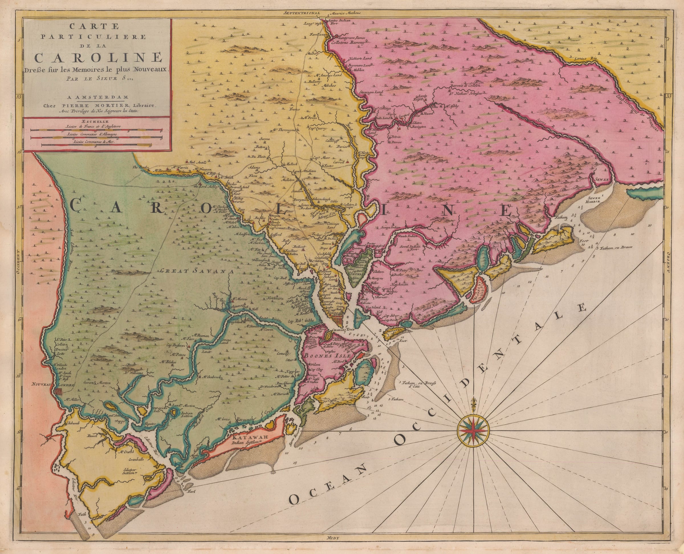
Carte Particuliere de la Caroline
Very fine and unusual example of Mortier's important map of the area around Charleston with multiple plantation names and the early trade route network.
Mortier's map was based on English surveys made just after Charles II granted the lands within the region to eight of his favourites, who became known as the Lords Proprietors. The third surveyor general of the region, Maurice Matthews was commissioned to produce a survey of the areas of Craven, Berkeley and Colleton Counties. This was used to produce a manuscript map by Joel Gascoyne in 1682 and both the map and the survey were again used for a map by the English commercial map makers, Robert Morden and John Thornton, probably working in partnership; they produced the first printed map focused on the area, which was also the first printed map of South Carolina c. 1695. Mortier used this printed map as a base and was the first map maker to produce a printed map of South Carolina outside of Great Britain, translating the title into French. Although the survey does not actively name the counties, the original colour does clearly differentiate three regions; of even greater interest are the names of approximately 250 landowners in the early colony.
Due to the information portrayed, this map is both an important historical document and this example is also a stunning artistic rendition due to the extraordinary quality of the original hand colour.
The "Neptune Francois" was first issued simultaneously in Paris and Amsterdam by Hubert Jaillot and Pierre Mortier respectively in 1693. The project was highly successful and Mortier developed the Atlas by adding two more sections or volumes to it. The first, Vol II was also issued in 1693 and consisted of a set of charts provided by the noted Dutch artist Romeyn de Hooghe. Collectively these are known as the "Cartes Marines a l'Usage des Armées du Roy de Grande Bretagne" and were originally drawn for William III of Great Britain. De Hooghe was primarily an artist and his charts bear a distinctive pictorial aspect. They have become renowned for their aesthetics, being cited as the most beautiful set of charts ever published. Volume III added in 1700, entitled "Suite de Neptune" concentrated on charts outside of French territory, including maps of the New World, the West Indies, South East Asia and the Indian Ocean among others.
Mortier's edition was a prestige work. Later scholars have found that his book was the most expensive sea atlas produced in Amsterdam up to that time. On the rare occasions that an example of one of the maps in full original colour can be obtained, it is easily perceived why this work is cited as one of the finest and most spectacular atlases ever produced.
Magnificent original hand colour. [USA9189]
Share
- Tumblr
Join our mailing list
* denotes required fields
We will process the personal data you have supplied to communicate with you in accordance with our Privacy Policy. You can unsubscribe or change your preferences at any time by clicking the link in our emails.
Contact
The Map House
54 Beauchamp Place,
London SW3 1NY,
United Kingdom
maps@themaphouse.com
+44 (0)20 7589 4325
![]()
Copyright © 2025 The Map House
This website uses cookies
This site uses cookies to help make it more useful to you. Please contact us to find out more about our Cookie Policy.