- All
- AFRICA
- ▪ Central Africa
- ▪ East Africa
- ▪ North Africa
- ▪ Southern Africa
- ▪ West Africa
- ▪ Atlantic Islands
- AMERICAS
-
▪ United States (USA)
- USA - East
- USA - Midwest
- USA - Northeast
- USA - Southeast
- USA - West & Southwest
- Alabama
- Alaska
- Arizona
- Arkansas
- California
- Colorado
- Connecticut
- Delaware
- Florida
- Georgia
- Hawaii
- Idaho
- Illinois
- Indiana
- Iowa
- Kansas
- Kentucky
- Louisiana
- Maine
- Maryland
- Massachusetts
- Michigan
- Minnesota
- Mississippi
- Missouri
- Montana
- Nebraska
- Nevada
- New Hampshire
- New Jersey
- New Mexico
- New York
- New York City
- North Carolina
- North Dakota
- Ohio
- Oklahoma
- Oregon
- Pennsylvania
- Rhode Island
- South Carolina
- South Dakota
- Tennessee
- Texas
- Utah
- Vermont
- Virginia
- Washington
- Washington, D.C.
- West Virginia
- Wisconsin
- Wyoming
- ▪ North America
- ▪ South America
- ▪ Caribbean
- ASIA
- ▪ East Asia
- ▪ Southeast Asia
- ▪ India & South Asia
- ▪ Middle East & Turkey
- BRITISH ISLES
- ▪ London
-
▪ England
- English Cities
- Bedfordshire
- Berkshire
- Buckinghamshire
- Cambridgeshire
- Cheshire
- Cornwall
- Cumbria
- Derbyshire
- Devon
- Dorset
- Durham
- Essex
- Gloucestershire
- Hampshire
- Herefordshire
- Hertfordshire
- Huntingdonshire
- Isle of Wight
- Kent
- Lancashire
- Leicestershire
- Lincolnshire
- Middlesex
- Norfolk
- Northamptonshire
- Northumberland
- Nottinghamshire
- Oxfordshire
- Rutland
- Shropshire
- Somerset
- Staffordshire
- Suffolk
- Surrey
- Sussex
- Warwickshire
- Wiltshire
- Worcestershire
- Yorkshire
- Yorkshire East Riding
- Yorkshire North Riding
- Yorkshire West Riding
- ▪ Ireland
- ▪ Scotland
- ▪ Wales
- EUROPE
- ▪ Austria & Switzerland
- ▪ Benelux Region
- ▪ Central & Eastern Europe
- ▪ France & Monaco
- ▪ Germany
- ▪ Greece
- ▪ Italy
- ▪ Mediterranean Sea
- ▪ Spain & Portugal
- ▪ Scandinavia & Baltics
- ▪ Russia, Ukraine & Caucasus
- OCEANIA
- ▪ Australia
- ▪ New Zealand
- ▪ Pacific Ocean & Islands
- ▪ Papua New Guinea
- POLAR
- CELESTIAL
- WORLD
- GLOBES & INSTRUMENTS
- THEMATIC
- COLLABORATIONS
Bowles & Carver
New Four Sheet Map of the World on Mercator's Projection, 1802
41 x 47 in
104 x 120 cm
104 x 120 cm
WLD4445
%3Cdiv%20class%3D%22artist%22%3EBowles%20%26%20Carver%3C/div%3E%3Cdiv%20class%3D%22title_and_year%22%3E%3Cspan%20class%3D%22title_and_year_title%22%3ENew%20Four%20Sheet%20Map%20of%20the%20World%20on%20Mercator%27s%20Projection%3C/span%3E%2C%20%3Cspan%20class%3D%22title_and_year_year%22%3E1802%3C/span%3E%3C/div%3E%3Cdiv%20class%3D%22dimensions%22%3E41%20x%2047%20in%3Cbr/%3E%0A104%20x%20120%20cm%3C/div%3E
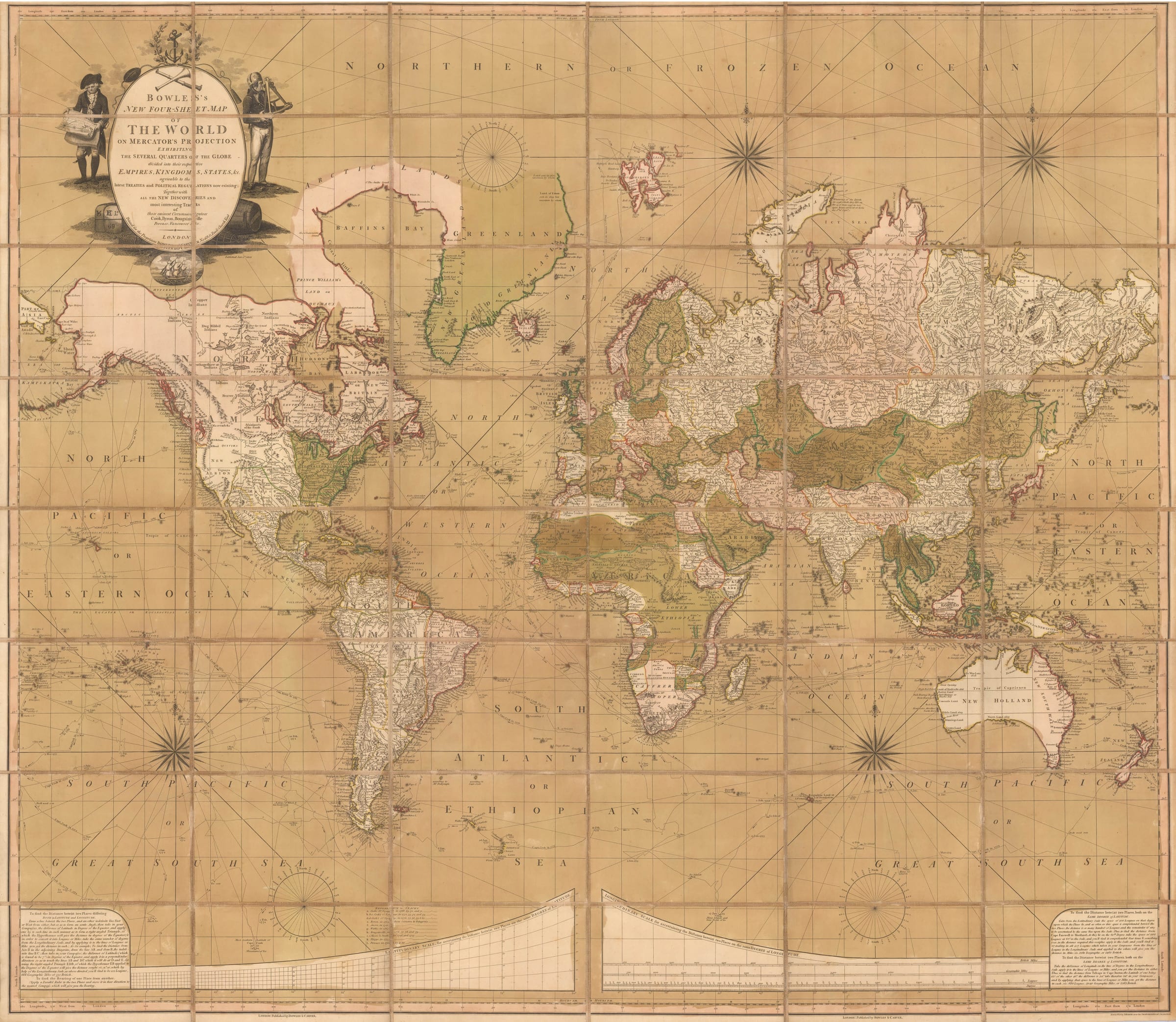
Folding wall map of the world on Mercator's Projection originally issued in the late 18th century but updated to show the latest discoveries to 1802. Bowles and Carver's map was...
Folding wall map of the world on Mercator's Projection originally issued in the late 18th century but updated to show the latest discoveries to 1802.
Bowles and Carver's map was very likely to have been published in competition with several similar large maps of the world published in the very late 18th century to showcase the extraordinary achievements of mariners such as Cook, Vancouver, Byron, Anson and La Perouse. These pieces must have been very successful as they were often issued several times with revisions and updates as newly communicated discoveries and information arrived in London through a combination of the famous voyages sponsored by the Royal Navy, a buoyant merchant marine and a thriving map trade. Bowles and Carver were part of this trade and extremely canny businessmen, with roots in publishing and printing that went back four generations into the early 18th century. Thus, they realised that the appetite of the public for these wall maps was growing and they decided to capitalise on this.
Bowles and Carver did not have special contacts in, or access to, the Admiralty or government, so they decided on a different approach. They hired one of the leading engravers of the time, Benjamin Baker, whose name appears on the lower left corner of the map, to combine an artistic statement together with a scientific document. The result would then be finely hand-coloured by professional artists. The map, while large, is not quite as monumental as some other wall maps of the period, making it far more accessible, both for practical space purposes as well as cost.
The geographical information is not innovative, relying on information current to the 18th century; the Far East is mainly based on French sources, namely D'Anville, while Africa is based on maps by D'Anville, Faden and Hase. South America is based on D'Anville again and politically quite simple, showing Spanish and Portuguese possessions, while North America shows the newly-independent United States bordered by Spanish possessions in the south and west and English possessions in the north. In general, the geography reflects knowledge current to the period before the Revolutionary and Napoleonic Wars with one exception. Australia is shown as joined onto Tasmania but if one observes closely, there is a faint channel separating the two; this suggests that news had reached London of the discovery of the Bass Straits by Matthew Flinders and George Bass but that proof of the shape, size or authenticity of this discovery had not been established.
The British Library have an example of this map published in 1790 by Carington Bowles which would tally with the geography; there is also an 1800 edition of the map, now published by Bowles and Carver. Our example is the 1802 edition, dated just below the cartouche and again published by Bowles and Carver; this was a reinvention of the firm when Henry Carington Bowles, son of Carington Bowles, formed a partnership with Samuel Carver and continued to issue and publish cartographic material into the early 19th century.
Finally, one must mention the large cartouche adorning the upper left corner on which, rather amusingly, the figure on the left appears to be consulting a copy of this very map, thereby producing an early example of the Droste Effect.
Original hand colour. Folded. [WLD4445]
Share
- Tumblr
Join our mailing list
* denotes required fields
We will process the personal data you have supplied to communicate with you in accordance with our Privacy Policy. You can unsubscribe or change your preferences at any time by clicking the link in our emails.
Contact
The Map House
54 Beauchamp Place,
London SW3 1NY,
United Kingdom
maps@themaphouse.com
+44 (0)20 7589 4325
![]()
Copyright © 2025 The Map House
This website uses cookies
This site uses cookies to help make it more useful to you. Please contact us to find out more about our Cookie Policy.