- All
- AFRICA
- ▪ Central Africa
- ▪ East Africa
- ▪ North Africa
- ▪ Southern Africa
- ▪ West Africa
- ▪ Atlantic Islands
- AMERICAS
-
▪ United States (USA)
- USA - East
- USA - Midwest
- USA - Northeast
- USA - Southeast
- USA - West & Southwest
- Alabama
- Alaska
- Arizona
- Arkansas
- California
- Colorado
- Connecticut
- Delaware
- Florida
- Georgia
- Hawaii
- Idaho
- Illinois
- Indiana
- Iowa
- Kansas
- Kentucky
- Louisiana
- Maine
- Maryland
- Massachusetts
- Michigan
- Minnesota
- Mississippi
- Missouri
- Montana
- Nebraska
- Nevada
- New Hampshire
- New Jersey
- New Mexico
- New York
- New York City
- North Carolina
- North Dakota
- Ohio
- Oklahoma
- Oregon
- Pennsylvania
- Rhode Island
- South Carolina
- South Dakota
- Tennessee
- Texas
- Utah
- Vermont
- Virginia
- Washington
- Washington, D.C.
- West Virginia
- Wisconsin
- Wyoming
- ▪ North America
- ▪ South America
- ▪ Caribbean
- ASIA
- ▪ East Asia
- ▪ Southeast Asia
- ▪ India & South Asia
- ▪ Middle East & Turkey
- BRITISH ISLES
- ▪ London
-
▪ England
- English Cities
- Bedfordshire
- Berkshire
- Buckinghamshire
- Cambridgeshire
- Cheshire
- Cornwall
- Cumbria
- Derbyshire
- Devon
- Dorset
- Durham
- Essex
- Gloucestershire
- Hampshire
- Herefordshire
- Hertfordshire
- Huntingdonshire
- Isle of Wight
- Kent
- Lancashire
- Leicestershire
- Lincolnshire
- Middlesex
- Norfolk
- Northamptonshire
- Northumberland
- Nottinghamshire
- Oxfordshire
- Rutland
- Shropshire
- Somerset
- Staffordshire
- Suffolk
- Surrey
- Sussex
- Warwickshire
- Wiltshire
- Worcestershire
- Yorkshire
- Yorkshire East Riding
- Yorkshire North Riding
- Yorkshire West Riding
- ▪ Ireland
- ▪ Scotland
- ▪ Wales
- EUROPE
- ▪ Austria & Switzerland
- ▪ Benelux Region
- ▪ Central & Eastern Europe
- ▪ France & Monaco
- ▪ Germany
- ▪ Greece
- ▪ Italy
- ▪ Mediterranean Sea
- ▪ Spain & Portugal
- ▪ Scandinavia & Baltics
- ▪ Russia, Ukraine & Caucasus
- OCEANIA
- ▪ Australia
- ▪ New Zealand
- ▪ Pacific Ocean & Islands
- ▪ Papua New Guinea
- POLAR
- CELESTIAL
- WORLD
- GLOBES & INSTRUMENTS
- THEMATIC
- COLLABORATIONS
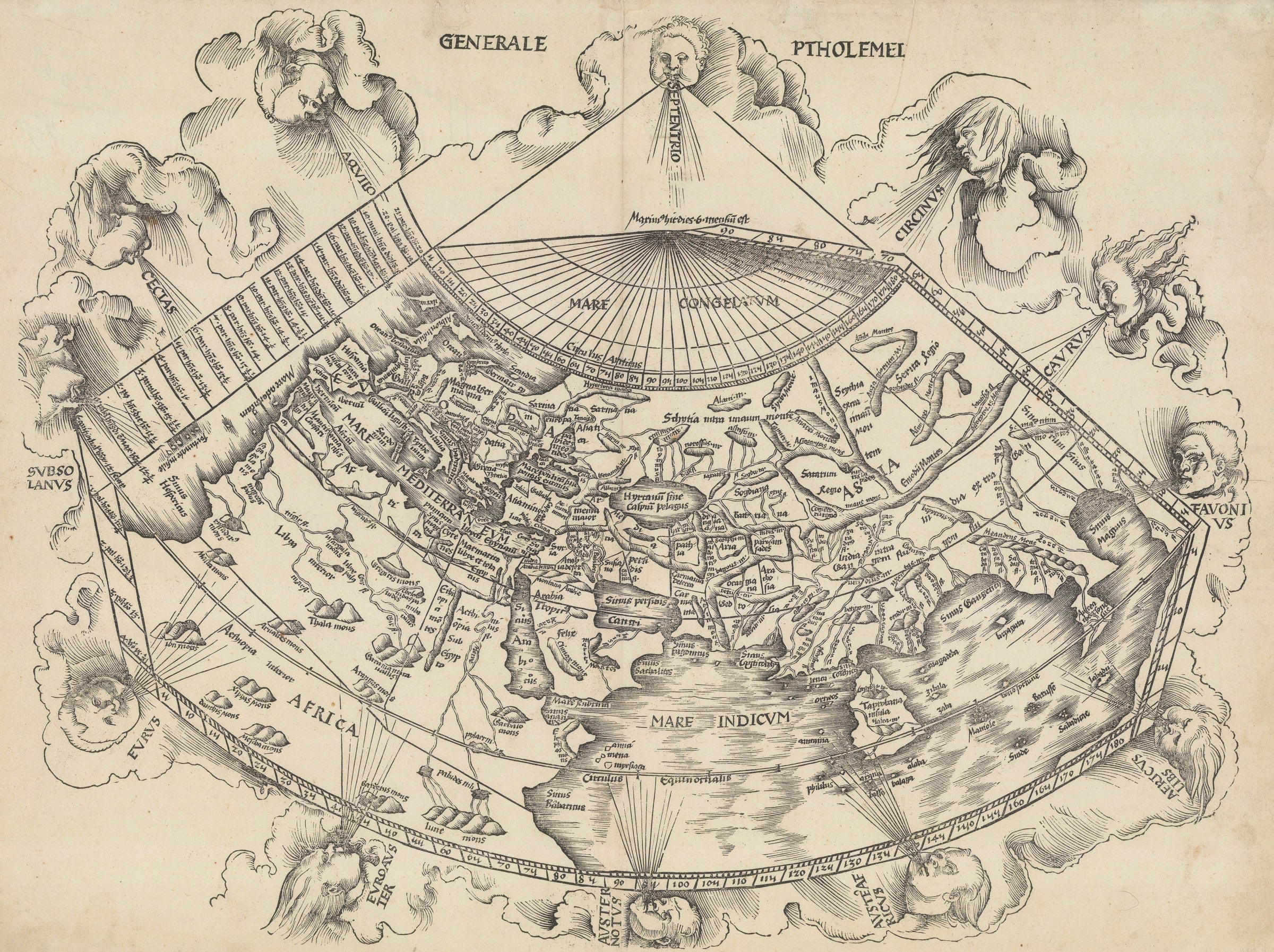
Claudius Ptolemy
"One of the most attractive Ptolemaic world maps produced", 1513
17 ½ x 23 ½ in
44 x 60 cm
44 x 60 cm
WLD4427
%3Cdiv%20class%3D%22artist%22%3EClaudius%20Ptolemy%3C/div%3E%3Cdiv%20class%3D%22title_and_year%22%3E%3Cspan%20class%3D%22title_and_year_title%22%3E%22One%20of%20the%20most%20attractive%20Ptolemaic%20world%20maps%20produced%22%3C/span%3E%2C%20%3Cspan%20class%3D%22title_and_year_year%22%3E1513%3C/span%3E%3C/div%3E%3Cdiv%20class%3D%22dimensions%22%3E17%20%C2%BD%20x%2023%20%C2%BD%20in%3Cbr/%3E%0A44%20x%2060%20cm%3C/div%3E
It would be difficult to choose the achievement which raised Martin Waldseemuller to one of the towering figures in the field of historical cartography. In 1507, he published his 'Cosmographiae...
It would be difficult to choose the achievement which raised Martin Waldseemuller to one of the towering figures in the field of historical cartography.
In 1507, he published his "Cosmographiae Introductio" in pamphlet form as an introduction to his re-issue of another work "The Four Voyages of Amerigo". In the 'Introductio', he includes a wall map of the world in multiple sheets showing the new discoveries made by Amerigo Vespucci and with the name 'America' on what is modern South America. Waldseemuller suggests that this newly discovered land be called after its discoverer. The idea was popular and eventually the whole of the New World became known under this new name; particularly so after a young Gerhard Mercator used it on his map published in 1538. This wall map is now known in one example in the Library of Congress and has been called "America's birth certificate".
The second reason for his importance is his issue of one of the most important "Geographias" based on Ptolemy. Printed in Strasbourg in 1513, it added 20 'modern' maps to the usual 27 Ptolemaic or classical maps, augmenting the traditional medieval view of the world with newly drawn charts which introduced geographical advances from the Age of Discovery for the first time.
The "Generale Ptholemei" is the traditional orthodox Ptolemaic map of the world with its "Mare Congelatum" in the north, climatic divisions and lines of longitude and latitude, its depiction of the classical world and primitive perception of the east all set within Ptolemy's very distinctive projection. However there is one crucial difference between this and earlier comparable maps. Waldseemuller does not include a land bridge between southern Africa and Asia, land locking the Indian Ocean; instead he leaves the southern edge of the map open.
There are several reasons as to why Waldseemuller may have decided on such a radical departure from tradition. It is known that he had read extensively about the Portuguese voyages along the west coast of Africa and around the Cape of Good Hope. Simultaneously, as a student, Waldseemuller attended the University of Freiburg c.1490 and studied under Gregor Reisch. In the early 16th century, Reisch published a popular hand book of philosophy, the "Margarita Philosophica". The 1503-4 editions of this work include a map. Again it is a traditional Ptolemaic map but with one major divergence. Although Reisch includes a land bridge between Africa and Asia, he makes a note on it in Latin, translated as 'Here is not land, but sea, in which there are such islands not conceived of by Ptolemy'.
Waldseemuller was known as a prolific correspondent, maintaining contact with a wide network of intellectuals and figures of influence. It is certainly not beyond the realms of possibility that he kept in touch with his old tutor and discussed new geographical advances and ideas, a subject which was dear to both their hearts. Another link is Johann Schott, who published both the "Margarita" and the 1513 "Geographia" and would have had access to both maps.
This is not the first printed Ptolemaic map to show an open Indian Ocean. That accolade goes to Bernard Sylvanus's issue of his "Geographia" in Venice in 1511, but it is known that the preparation time for the 1513 edition was particularly long, probably because of the inclusion of the 20 'modern maps' in the work. Waldseemuller and his partner Matthias Ringmann began work on the volume c.1505. Traditionally, the map of the world is the first to be prepared so, so the wood cut may have been made only two years after the printing of the map within the "Margarita" with its provocative statement on the Indian Ocean. Aesthetically, the map again sticks to the orthodox multiple human heads within clouds representing the winds.
Framed.
[WLD4427]
Publications
Shirley, 34.
Share
- Tumblr
Join our mailing list
* denotes required fields
We will process the personal data you have supplied to communicate with you in accordance with our Privacy Policy. You can unsubscribe or change your preferences at any time by clicking the link in our emails.
Contact
The Map House
54 Beauchamp Place,
London SW3 1NY,
United Kingdom
maps@themaphouse.com
+44 (0)20 7589 4325
![]()
Copyright © 2025 The Map House
This website uses cookies
This site uses cookies to help make it more useful to you. Please contact us to find out more about our Cookie Policy.