- All
- AFRICA
- ▪ Central Africa
- ▪ East Africa
- ▪ North Africa
- ▪ Southern Africa
- ▪ West Africa
- ▪ Atlantic Islands
- AMERICAS
-
▪ United States (USA)
- USA - East
- USA - Midwest
- USA - Northeast
- USA - Southeast
- USA - West & Southwest
- Alabama
- Alaska
- Arizona
- Arkansas
- California
- Colorado
- Connecticut
- Delaware
- Florida
- Georgia
- Hawaii
- Idaho
- Illinois
- Indiana
- Iowa
- Kansas
- Kentucky
- Louisiana
- Maine
- Maryland
- Massachusetts
- Michigan
- Minnesota
- Mississippi
- Missouri
- Montana
- Nebraska
- Nevada
- New Hampshire
- New Jersey
- New Mexico
- New York
- New York City
- North Carolina
- North Dakota
- Ohio
- Oklahoma
- Oregon
- Pennsylvania
- Rhode Island
- South Carolina
- South Dakota
- Tennessee
- Texas
- Utah
- Vermont
- Virginia
- Washington
- Washington, D.C.
- West Virginia
- Wisconsin
- Wyoming
- ▪ North America
- ▪ South America
- ▪ Caribbean
- ASIA
- ▪ East Asia
- ▪ Southeast Asia
- ▪ India & South Asia
- ▪ Middle East & Turkey
- BRITISH ISLES
- ▪ London
-
▪ England
- English Cities
- Bedfordshire
- Berkshire
- Buckinghamshire
- Cambridgeshire
- Cheshire
- Cornwall
- Cumbria
- Derbyshire
- Devon
- Dorset
- Durham
- Essex
- Gloucestershire
- Hampshire
- Herefordshire
- Hertfordshire
- Huntingdonshire
- Isle of Wight
- Kent
- Lancashire
- Leicestershire
- Lincolnshire
- Middlesex
- Norfolk
- Northamptonshire
- Northumberland
- Nottinghamshire
- Oxfordshire
- Rutland
- Shropshire
- Somerset
- Staffordshire
- Suffolk
- Surrey
- Sussex
- Warwickshire
- Wiltshire
- Worcestershire
- Yorkshire
- Yorkshire East Riding
- Yorkshire North Riding
- Yorkshire West Riding
- ▪ Ireland
- ▪ Scotland
- ▪ Wales
- EUROPE
- ▪ Austria & Switzerland
- ▪ Benelux Region
- ▪ Central & Eastern Europe
- ▪ France & Monaco
- ▪ Germany
- ▪ Greece
- ▪ Italy
- ▪ Mediterranean Sea
- ▪ Spain & Portugal
- ▪ Scandinavia & Baltics
- ▪ Russia, Ukraine & Caucasus
- OCEANIA
- ▪ Australia
- ▪ New Zealand
- ▪ Pacific Ocean & Islands
- ▪ Papua New Guinea
- POLAR
- CELESTIAL
- WORLD
- GLOBES & INSTRUMENTS
- THEMATIC
- COLLABORATIONS
Abraham Ortelius
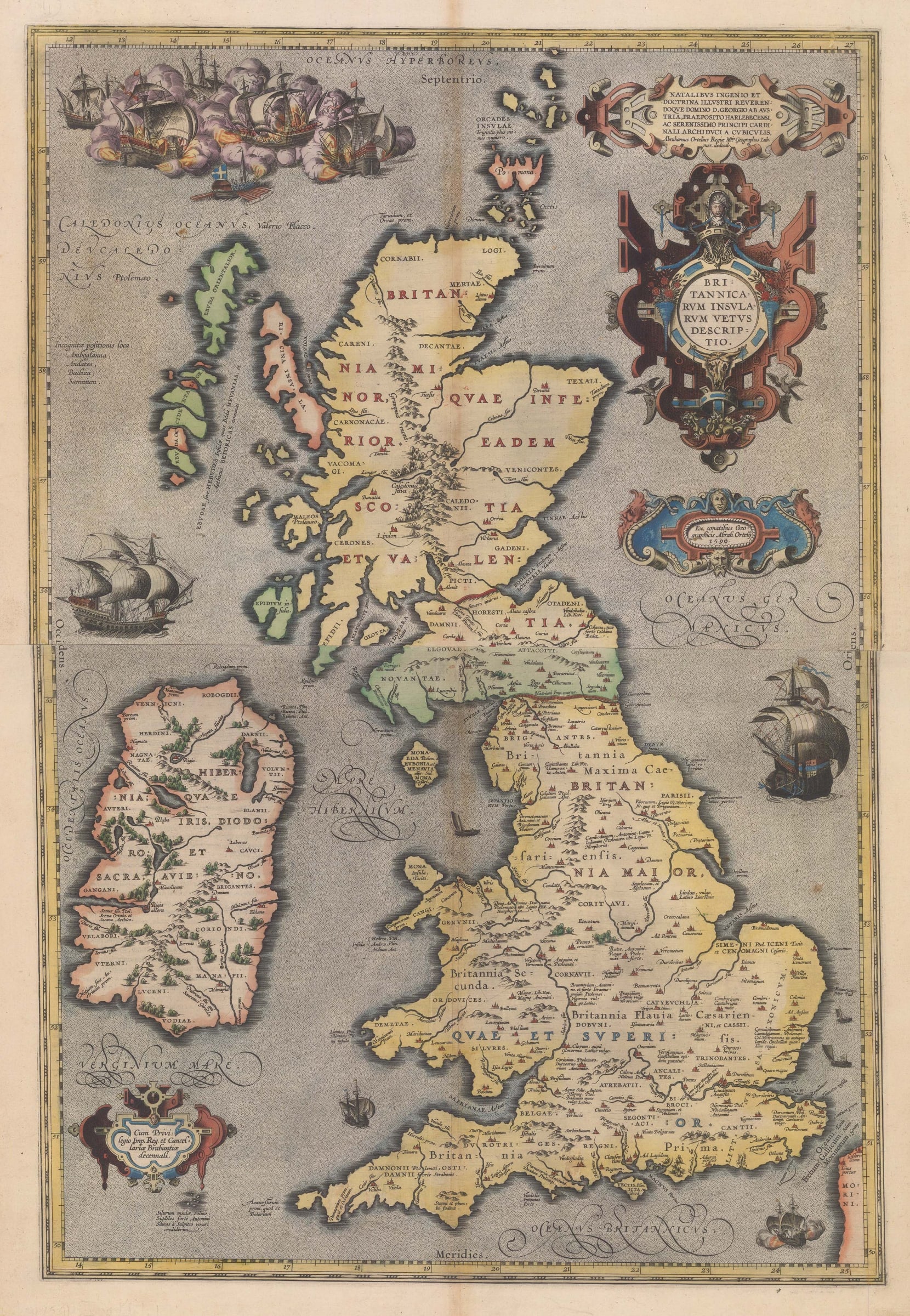
Ortelius's Rare 2-Sheet Map of Britain, 1590
28 ½ x 19 ½ in
73 x 49 cm
73 x 49 cm
GB1965
%3Cdiv%20class%3D%22artist%22%3EAbraham%20Ortelius%3C/div%3E%3Cdiv%20class%3D%22title_and_year%22%3E%3Cspan%20class%3D%22title_and_year_title%22%3EOrtelius%27s%20Rare%202-Sheet%20Map%20of%20Britain%3C/span%3E%2C%20%3Cspan%20class%3D%22title_and_year_year%22%3E1590%3C/span%3E%3C/div%3E%3Cdiv%20class%3D%22dimensions%22%3E28%20%C2%BD%20x%2019%20%C2%BD%20in%3Cbr/%3E%0A73%20x%2049%20cm%3C/div%3E
Britannicarum Insularum Vetus Descriptio Rare two-sheet map of ancient Great Britain and Ireland decorated with strapwork cartouches and a naval battle scene, the most elaborate on any of Ortelius's...
Britannicarum Insularum Vetus Descriptio
Rare two-sheet map of ancient Great Britain and Ireland decorated with strapwork cartouches and a naval battle scene, the most elaborate on any of Ortelius's maps. Unusually, Ortelius credits his own geographical studies for the creation of this map rather than a contemporary scholar. Though as Ortelius was an avid historian with a particular interest in the writings of the Roman period, this is quite understandable. Latin text on the verso provides a history of ancient Britain and Ireland according to classical authors.
This specific map was only published in the 1590, 1591, and 1592 editions of Ortelius's "Theatrum Orbis Terrarum", the first modern world atlas, though a handful of 'leftover' copies have been found in the 1602 edition as well. Fewer than 750 copies of this map were thought to have been published. It was replaced in the 1595 edition by the more common, smaller, single-sheet map.
Latin text on verso (image available on request). Fine original hand-colour.
[GB1965]
Share
- Tumblr
Join our mailing list
* denotes required fields
We will process the personal data you have supplied to communicate with you in accordance with our Privacy Policy. You can unsubscribe or change your preferences at any time by clicking the link in our emails.
Contact
The Map House
54 Beauchamp Place,
London SW3 1NY,
United Kingdom
maps@themaphouse.com
+44 (0)20 7589 4325
![]()
Copyright © 2025 The Map House
This website uses cookies
This site uses cookies to help make it more useful to you. Please contact us to find out more about our Cookie Policy.