- All
- AFRICA
- ▪ Central Africa
- ▪ East Africa
- ▪ North Africa
- ▪ Southern Africa
- ▪ West Africa
- ▪ Atlantic Islands
- AMERICAS
-
▪ United States (USA)
- USA - East
- USA - Midwest
- USA - Northeast
- USA - Southeast
- USA - West & Southwest
- Alabama
- Alaska
- Arizona
- Arkansas
- California
- Colorado
- Connecticut
- Delaware
- Florida
- Georgia
- Hawaii
- Idaho
- Illinois
- Indiana
- Iowa
- Kansas
- Kentucky
- Louisiana
- Maine
- Maryland
- Massachusetts
- Michigan
- Minnesota
- Mississippi
- Missouri
- Montana
- Nebraska
- Nevada
- New Hampshire
- New Jersey
- New Mexico
- New York
- New York City
- North Carolina
- North Dakota
- Ohio
- Oklahoma
- Oregon
- Pennsylvania
- Rhode Island
- South Carolina
- South Dakota
- Tennessee
- Texas
- Utah
- Vermont
- Virginia
- Washington
- Washington, D.C.
- West Virginia
- Wisconsin
- Wyoming
- ▪ North America
- ▪ South America
- ▪ Caribbean
- ASIA
- ▪ East Asia
- ▪ Southeast Asia
- ▪ India & South Asia
- ▪ Middle East & Turkey
- BRITISH ISLES
- ▪ London
-
▪ England
- English Cities
- Bedfordshire
- Berkshire
- Buckinghamshire
- Cambridgeshire
- Cheshire
- Cornwall
- Cumbria
- Derbyshire
- Devon
- Dorset
- Durham
- Essex
- Gloucestershire
- Hampshire
- Herefordshire
- Hertfordshire
- Huntingdonshire
- Isle of Wight
- Kent
- Lancashire
- Leicestershire
- Lincolnshire
- Middlesex
- Norfolk
- Northamptonshire
- Northumberland
- Nottinghamshire
- Oxfordshire
- Rutland
- Shropshire
- Somerset
- Staffordshire
- Suffolk
- Surrey
- Sussex
- Warwickshire
- Wiltshire
- Worcestershire
- Yorkshire
- Yorkshire East Riding
- Yorkshire North Riding
- Yorkshire West Riding
- ▪ Ireland
- ▪ Scotland
- ▪ Wales
- EUROPE
- ▪ Austria & Switzerland
- ▪ Benelux Region
- ▪ Central & Eastern Europe
- ▪ France & Monaco
- ▪ Germany
- ▪ Greece
- ▪ Italy
- ▪ Mediterranean Sea
- ▪ Spain & Portugal
- ▪ Scandinavia & Baltics
- ▪ Russia, Ukraine & Caucasus
- OCEANIA
- ▪ Australia
- ▪ New Zealand
- ▪ Pacific Ocean & Islands
- ▪ Papua New Guinea
- POLAR
- CELESTIAL
- WORLD
- GLOBES & INSTRUMENTS
- THEMATIC
- COLLABORATIONS
William Faden
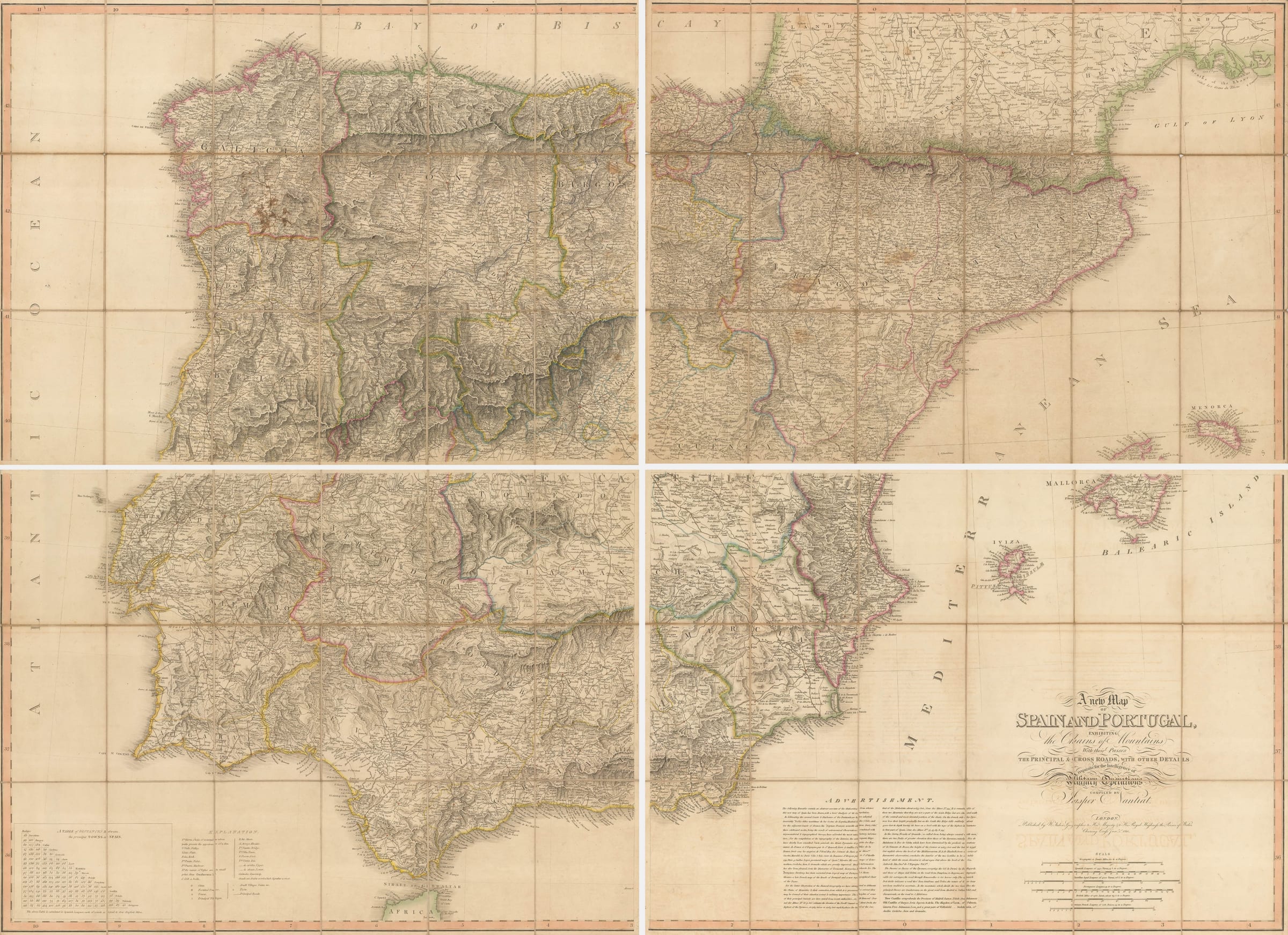
Peninsular War map of Spain & Portugal, 1810
45 ½ x 63 in
116 x 160 cm
Each sheet: 58 x 80 cm
116 x 160 cm
Each sheet: 58 x 80 cm
SP2058
£ 2,250.00
William Faden, Peninsular War map of Spain & Portugal, 1810
Sold
%3Cdiv%20class%3D%22artist%22%3EWilliam%20Faden%3C/div%3E%3Cdiv%20class%3D%22title_and_year%22%3E%3Cspan%20class%3D%22title_and_year_title%22%3EPeninsular%20War%20map%20of%20Spain%20%26%20Portugal%3C/span%3E%2C%20%3Cspan%20class%3D%22title_and_year_year%22%3E1810%3C/span%3E%3C/div%3E%3Cdiv%20class%3D%22dimensions%22%3E45%20%C2%BD%20x%2063%20in%3Cbr/%3E%0A116%20x%20160%20cm%3Cbr/%3E%0AEach%20sheet%3A%2058%20x%2080%20cm%3C/div%3E
A New Map of Spain and Portugal [...] requisite for the Intelligence of Military Operations Monumental four-sheet map of Spain and Portugal produced by William Faden, Geographer to King...
A New Map of Spain and Portugal [...] requisite for the Intelligence of Military Operations
Monumental four-sheet map of Spain and Portugal produced by William Faden, Geographer to King George III, for use by British military officers during the Peninsular War. Particular emphasis is given to the terrain, mountain passes, and roads, all of which were crucial for planning a military campaign.
Manuscript notations on the case identify the original owner as Major John Duffy of the 43rd Light Infantry. Further manuscript notations on the map itself mark the route of the Allied campaign of 1812 in pursuit of the retreating French armies from Ciudad Rodrigo on the Portuese border to Bayonne.
Major (later Major-General) Duffy served in virtually every theatre of the Napoleonic Wars - West Indies (1796), Netherlands (1796), Egypt (1807), Copenhagen (1807), and the Peninsula (1808-1814). He was wounded at Vittoria and was mentioned several times in Wellington's dispatches, particularly for his brave conduct leading the assault on Fort Reynard, an outpost of Ciudad Rodrigo.
A remarkable piece of military history, unusual in that it was actually used in the field by an identified British officer.
Original hand-colour. Folded in four sections with original slip case. [SP2058]
Share
- Tumblr
Join our mailing list
* denotes required fields
We will process the personal data you have supplied to communicate with you in accordance with our Privacy Policy. You can unsubscribe or change your preferences at any time by clicking the link in our emails.
Contact
The Map House
54 Beauchamp Place,
London SW3 1NY,
United Kingdom
maps@themaphouse.com
+44 (0)20 7589 4325
![]()
Copyright © 2025 The Map House
This website uses cookies
This site uses cookies to help make it more useful to you. Please contact us to find out more about our Cookie Policy.