- All
- AFRICA
- ▪ Central Africa
- ▪ East Africa
- ▪ North Africa
- ▪ Southern Africa
- ▪ West Africa
- ▪ Atlantic Islands
- AMERICAS
-
▪ United States (USA)
- USA - East
- USA - Midwest
- USA - Northeast
- USA - Southeast
- USA - West & Southwest
- Alabama
- Alaska
- Arizona
- Arkansas
- California
- Colorado
- Connecticut
- Delaware
- Florida
- Georgia
- Hawaii
- Idaho
- Illinois
- Indiana
- Iowa
- Kansas
- Kentucky
- Louisiana
- Maine
- Maryland
- Massachusetts
- Michigan
- Minnesota
- Mississippi
- Missouri
- Montana
- Nebraska
- Nevada
- New Hampshire
- New Jersey
- New Mexico
- New York
- New York City
- North Carolina
- North Dakota
- Ohio
- Oklahoma
- Oregon
- Pennsylvania
- Rhode Island
- South Carolina
- South Dakota
- Tennessee
- Texas
- Utah
- Vermont
- Virginia
- Washington
- Washington, D.C.
- West Virginia
- Wisconsin
- Wyoming
- ▪ North America
- ▪ South America
- ▪ Caribbean
- ASIA
- ▪ East Asia
- ▪ Southeast Asia
- ▪ India & South Asia
- ▪ Middle East & Turkey
- BRITISH ISLES
- ▪ London
-
▪ England
- English Cities
- Bedfordshire
- Berkshire
- Buckinghamshire
- Cambridgeshire
- Cheshire
- Cornwall
- Cumbria
- Derbyshire
- Devon
- Dorset
- Durham
- Essex
- Gloucestershire
- Hampshire
- Herefordshire
- Hertfordshire
- Huntingdonshire
- Isle of Wight
- Kent
- Lancashire
- Leicestershire
- Lincolnshire
- Middlesex
- Norfolk
- Northamptonshire
- Northumberland
- Nottinghamshire
- Oxfordshire
- Rutland
- Shropshire
- Somerset
- Staffordshire
- Suffolk
- Surrey
- Sussex
- Warwickshire
- Wiltshire
- Worcestershire
- Yorkshire
- Yorkshire East Riding
- Yorkshire North Riding
- Yorkshire West Riding
- ▪ Ireland
- ▪ Scotland
- ▪ Wales
- EUROPE
- ▪ Austria & Switzerland
- ▪ Benelux Region
- ▪ Central & Eastern Europe
- ▪ France & Monaco
- ▪ Germany
- ▪ Greece
- ▪ Italy
- ▪ Mediterranean Sea
- ▪ Spain & Portugal
- ▪ Scandinavia & Baltics
- ▪ Russia, Ukraine & Caucasus
- OCEANIA
- ▪ Australia
- ▪ New Zealand
- ▪ Pacific Ocean & Islands
- ▪ Papua New Guinea
- POLAR
- CELESTIAL
- WORLD
- GLOBES & INSTRUMENTS
- THEMATIC
- COLLABORATIONS
Victor Clerot
92 x 129 cm
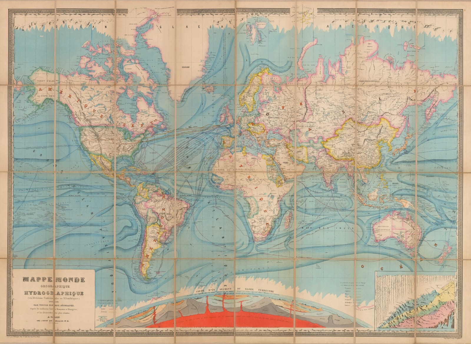
We have been able to locate one institutional example of this map which is dated 1856. Our example bears a note on the northwest of Greenland, stating simply "furthest north, 1876" referring to Sir George Nares's British Arctic Expedition of 1875-6, which broke the long standing record of "furthest North" set by Sir William Parry, made during his attempt to reach the North Pole in 1825. The Nares Expedition also proved that the theorised "Open Polar Sea" did not exist. Geopolitically, the map also shows Bolivia as having access to the Pacific, which they lost after the War of the Pacific of 1884, suggesting this version of the map was issued c.1880, providing a long publishing history for this piece.
One of the major aspects on which this map focuses is the growing logistical network of the world. The most eye catching feature is the multiplicity of steam packet routes on all the oceans. The key on the lower left shows a focus on English, French and America routes but even just those give an indication of the vast increase in marine traffic in the 19th century. As had become common, these routes also state the ports of departure and arrival together with time and distance between destinations. Another notable addition to this logistical showcase is the marking of the newly completed Trans-Continental Railroad between New York and San Francisco, finally finished in 1869.
The other focus of this map is scientific. It touches upon oceanography, showing several currents by using a deeper blue throughout the oceans. Oceanic ice fields are marked on both the North and South Poles and there is a small diagram on the lower right showing the comparative heights of the tallest mountains found up to the point together with the lengths of rivers. This map states that the Amazon was the longest river in the world. However, the map is dominated by the large vignette on the lower centre of a diagram modelling the earth's crust with the names of geological layers.
The heavy use of colour, especially the strong orange indicating the earth's molten core, is particularly striking in this highly attractive example of late 19th century cartography.
FRAMED. [WLD4130]
- X
- Tumblr
Join our mailing list
* denotes required fields
We will process the personal data you have supplied to communicate with you in accordance with our Privacy Policy. You can unsubscribe or change your preferences at any time by clicking the link in our emails.
Contact
The Map House
54 Beauchamp Place,
London SW3 1NY,
United Kingdom
maps@themaphouse.com
+44 (0)20 7589 4325

This website uses cookies
This site uses cookies to help make it more useful to you. Please contact us to find out more about our Cookie Policy.
Join our mailing list
* denotes required fields
We will process the personal data you have supplied to communicate with you in accordance with our Privacy Policy. You can unsubscribe or change your preferences at any time by clicking the link in our emails.

