- All
- AFRICA
- ▪ Central Africa
- ▪ East Africa
- ▪ North Africa
- ▪ Southern Africa
- ▪ West Africa
- ▪ Atlantic Islands
- AMERICAS
-
▪ United States (USA)
- USA - East
- USA - Midwest
- USA - Northeast
- USA - Southeast
- USA - West & Southwest
- Alabama
- Alaska
- Arizona
- Arkansas
- California
- Colorado
- Connecticut
- Delaware
- Florida
- Georgia
- Hawaii
- Idaho
- Illinois
- Indiana
- Iowa
- Kansas
- Kentucky
- Louisiana
- Maine
- Maryland
- Massachusetts
- Michigan
- Minnesota
- Mississippi
- Missouri
- Montana
- Nebraska
- Nevada
- New Hampshire
- New Jersey
- New Mexico
- New York
- New York City
- North Carolina
- North Dakota
- Ohio
- Oklahoma
- Oregon
- Pennsylvania
- Rhode Island
- South Carolina
- South Dakota
- Tennessee
- Texas
- Utah
- Vermont
- Virginia
- Washington
- Washington, D.C.
- West Virginia
- Wisconsin
- Wyoming
- ▪ North America
- ▪ South America
- ▪ Caribbean
- ASIA
- ▪ East Asia
- ▪ Southeast Asia
- ▪ India & South Asia
- ▪ Middle East & Turkey
- BRITISH ISLES
- ▪ London
-
▪ England
- English Cities
- Bedfordshire
- Berkshire
- Buckinghamshire
- Cambridgeshire
- Cheshire
- Cornwall
- Cumbria
- Derbyshire
- Devon
- Dorset
- Durham
- Essex
- Gloucestershire
- Hampshire
- Herefordshire
- Hertfordshire
- Huntingdonshire
- Isle of Wight
- Kent
- Lancashire
- Leicestershire
- Lincolnshire
- Middlesex
- Norfolk
- Northamptonshire
- Northumberland
- Nottinghamshire
- Oxfordshire
- Rutland
- Shropshire
- Somerset
- Staffordshire
- Suffolk
- Surrey
- Sussex
- Warwickshire
- Wiltshire
- Worcestershire
- Yorkshire
- Yorkshire East Riding
- Yorkshire North Riding
- Yorkshire West Riding
- ▪ Ireland
- ▪ Scotland
- ▪ Wales
- EUROPE
- ▪ Austria & Switzerland
- ▪ Benelux Region
- ▪ Central & Eastern Europe
- ▪ France & Monaco
- ▪ Germany
- ▪ Greece
- ▪ Italy
- ▪ Mediterranean Sea
- ▪ Spain & Portugal
- ▪ Scandinavia & Baltics
- ▪ Russia, Ukraine & Caucasus
- OCEANIA
- ▪ Australia
- ▪ New Zealand
- ▪ Pacific Ocean & Islands
- ▪ Papua New Guinea
- POLAR
- CELESTIAL
- WORLD
- GLOBES & INSTRUMENTS
- THEMATIC
- COLLABORATIONS
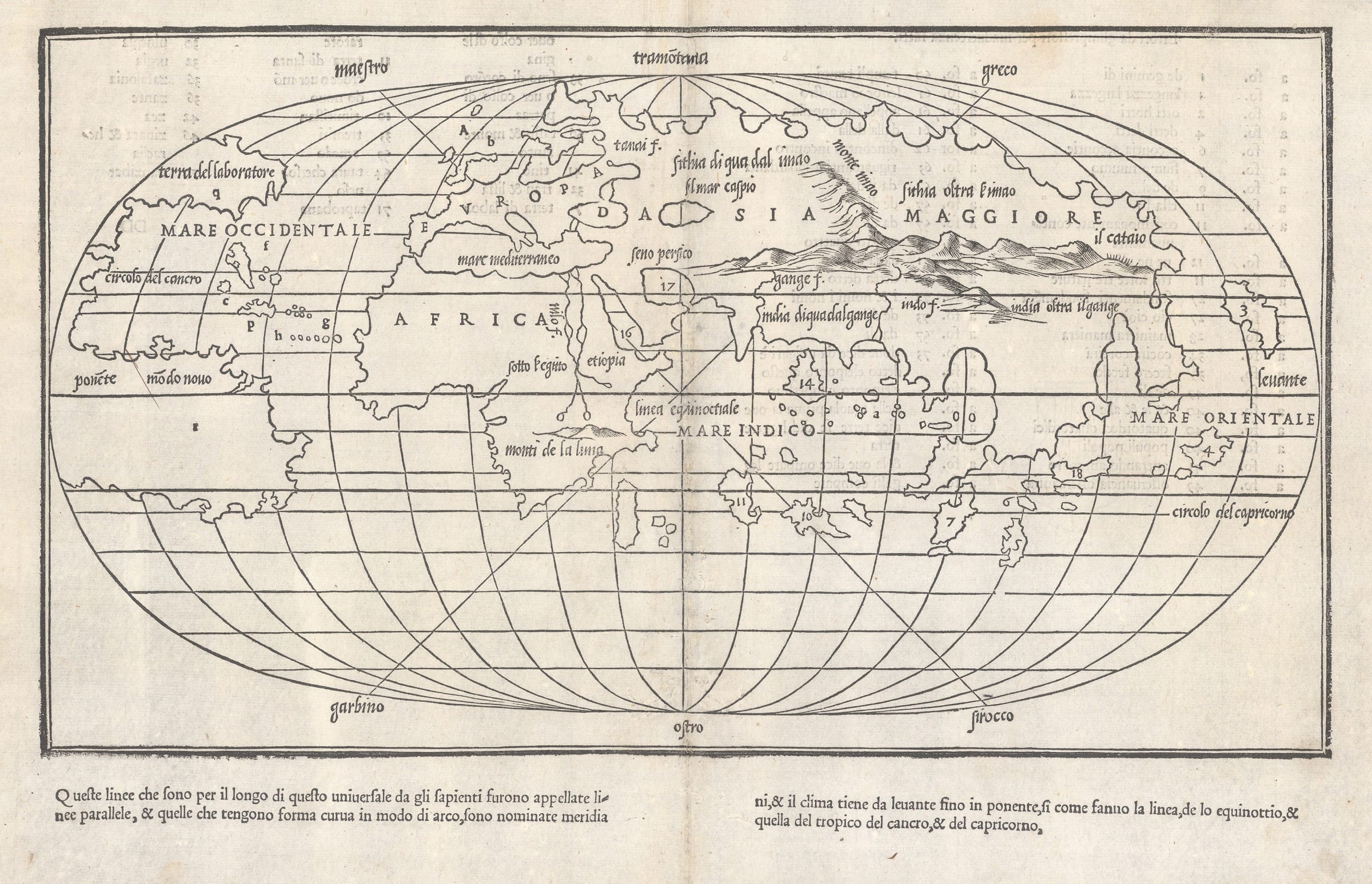
Benedetto Bordone
The Second Oval World Map, 1528
9 ½ x 15 in
24 x 38 cm
24 x 38 cm
WLD4096
%3Cdiv%20class%3D%22artist%22%3EBenedetto%20Bordone%3C/div%3E%3Cdiv%20class%3D%22title_and_year%22%3E%3Cspan%20class%3D%22title_and_year_title%22%3EThe%20Second%20Oval%20World%20Map%3C/span%3E%2C%20%3Cspan%20class%3D%22title_and_year_year%22%3E1528%3C/span%3E%3C/div%3E%3Cdiv%20class%3D%22dimensions%22%3E9%20%C2%BD%20x%2015%20in%3Cbr/%3E%0A24%20x%2038%20cm%3C/div%3E
Bordone was born in 1460 and educated in Padua. He became an illuminator, engraver, cartographer and editor working in Venice. In 1528, he issued a work entitled 'Libro di Benedetto...
Bordone was born in 1460 and educated in Padua. He became an illuminator, engraver, cartographer and editor working in Venice. In 1528, he issued a work entitled "Libro di Benedetto Bordone nel qual si ragiona de tutte l'isole del Mondo" more commonly known as Bordone's Isolario. The work was a geographical catalogue of the islands of the world, including several which had been newly discovered. Although these 'Isolarios' were a popular form of geography book, the Bordone Isolario was only the second one to be published in printed form. Due to its antiquity, it contained several maps of specific islands printed for the first time, including Japan (Ciampagu, Number 3 on the world map) and, possibly, North America (Terra del Lavoratore, map 'q' on the world map) although that is subject to interpretation. North America aside, there is no doubt that the work contains multiple maps which are extremely early depictions of some of the then most exotic recent European discoveries, such as Hispaniola, (Dominican Republic and Haiti), Taprobana (Sri Lanka or Sumatra), and Cuba together with more orthodox classical islands such as Sicily and Crete. The volume also contains several very early city plans such as Venice together with Temitistan, or Mexico City.
The double page map of the world is quite rudimentary, with only the continents and the oceans named. It serves more as an index map, marked with several numbers and letters, guiding the reader to specific maps within the Isolario. The map incorporates Portuguese and Spanish discoveries of the New World and Far East into its geography, with depictions of North and South America, the West Indies, the above mentioned Japan together with greater detail in the Far East, probably gleaned from the writings of Marco Polo. Curiously, a large peninsula west of Japan, could be interpreted as a very early depiction of Korea.
Bordone follows Waldseemuller's theory that North America and the New World is possibly part of Asia but the connection has not been discovered as yet. It shies away from Cantorini's and Ruysch's theories of a direct land connection between the two continents with this map leaving the relationship between the western coast of the New World and Asia as an open question. Despite this confusion, overall, it is a remarkably accurate depiction of the known world at the time.
On a different note, due to its context and general depiction, this is the second printed map on an oval projection and also one the earliest maps available to collectors which could be interpreted as a sea chart.
[Shirley 59] [WLD4096]
Share
- Tumblr
Join our mailing list
* denotes required fields
We will process the personal data you have supplied to communicate with you in accordance with our Privacy Policy. You can unsubscribe or change your preferences at any time by clicking the link in our emails.
Contact
The Map House
54 Beauchamp Place,
London SW3 1NY,
United Kingdom
maps@themaphouse.com
+44 (0)20 7589 4325
![]()
Copyright © 2025 The Map House
This website uses cookies
This site uses cookies to help make it more useful to you. Please contact us to find out more about our Cookie Policy.