- All
- AFRICA
- ▪ Central Africa
- ▪ East Africa
- ▪ North Africa
- ▪ Southern Africa
- ▪ West Africa
- ▪ Atlantic Islands
- AMERICAS
-
▪ United States (USA)
- USA - East
- USA - Midwest
- USA - Northeast
- USA - Southeast
- USA - West & Southwest
- Alabama
- Alaska
- Arizona
- Arkansas
- California
- Colorado
- Connecticut
- Delaware
- Florida
- Georgia
- Hawaii
- Idaho
- Illinois
- Indiana
- Iowa
- Kansas
- Kentucky
- Louisiana
- Maine
- Maryland
- Massachusetts
- Michigan
- Minnesota
- Mississippi
- Missouri
- Montana
- Nebraska
- Nevada
- New Hampshire
- New Jersey
- New Mexico
- New York
- New York City
- North Carolina
- North Dakota
- Ohio
- Oklahoma
- Oregon
- Pennsylvania
- Rhode Island
- South Carolina
- South Dakota
- Tennessee
- Texas
- Utah
- Vermont
- Virginia
- Washington
- Washington, D.C.
- West Virginia
- Wisconsin
- Wyoming
- ▪ North America
- ▪ South America
- ▪ Caribbean
- ASIA
- ▪ East Asia
- ▪ Southeast Asia
- ▪ India & South Asia
- ▪ Middle East & Turkey
- BRITISH ISLES
- ▪ London
-
▪ England
- English Cities
- Bedfordshire
- Berkshire
- Buckinghamshire
- Cambridgeshire
- Cheshire
- Cornwall
- Cumbria
- Derbyshire
- Devon
- Dorset
- Durham
- Essex
- Gloucestershire
- Hampshire
- Herefordshire
- Hertfordshire
- Huntingdonshire
- Isle of Wight
- Kent
- Lancashire
- Leicestershire
- Lincolnshire
- Middlesex
- Norfolk
- Northamptonshire
- Northumberland
- Nottinghamshire
- Oxfordshire
- Rutland
- Shropshire
- Somerset
- Staffordshire
- Suffolk
- Surrey
- Sussex
- Warwickshire
- Wiltshire
- Worcestershire
- Yorkshire
- Yorkshire East Riding
- Yorkshire North Riding
- Yorkshire West Riding
- ▪ Ireland
- ▪ Scotland
- ▪ Wales
- EUROPE
- ▪ Austria & Switzerland
- ▪ Benelux Region
- ▪ Central & Eastern Europe
- ▪ France & Monaco
- ▪ Germany
- ▪ Greece
- ▪ Italy
- ▪ Mediterranean Sea
- ▪ Spain & Portugal
- ▪ Scandinavia & Baltics
- ▪ Russia, Ukraine & Caucasus
- OCEANIA
- ▪ Australia
- ▪ New Zealand
- ▪ Pacific Ocean & Islands
- ▪ Papua New Guinea
- POLAR
- CELESTIAL
- WORLD
- GLOBES & INSTRUMENTS
- THEMATIC
- COLLABORATIONS
Sebastian Münster
Switzerland, 1558
11 x 14 1/2 in
28 x 36.5 cm
28 x 36.5 cm
SWAS1439
£ 275.00
Sebastian Münster, Switzerland, 1558
Sold
%3Cdiv%20class%3D%22artist%22%3ESebastian%20M%C3%BCnster%3C/div%3E%3Cdiv%20class%3D%22title_and_year%22%3E%3Cspan%20class%3D%22title_and_year_title%22%3ESwitzerland%3C/span%3E%2C%20%3Cspan%20class%3D%22title_and_year_year%22%3E1558%3C/span%3E%3C/div%3E%3Cdiv%20class%3D%22dimensions%22%3E11%20x%2014%201/2%20in%3Cbr/%3E%0A28%20x%2036.5%20cm%3C/div%3E
Helvetiae Moderna Descriptio Early map of Switzerland with pictorial towns and mountain ranges. An archetypal example of 16th century wood-block printing. SEBASTIAN MUNSTER 1489-1552 Munster was a true Renaissance...
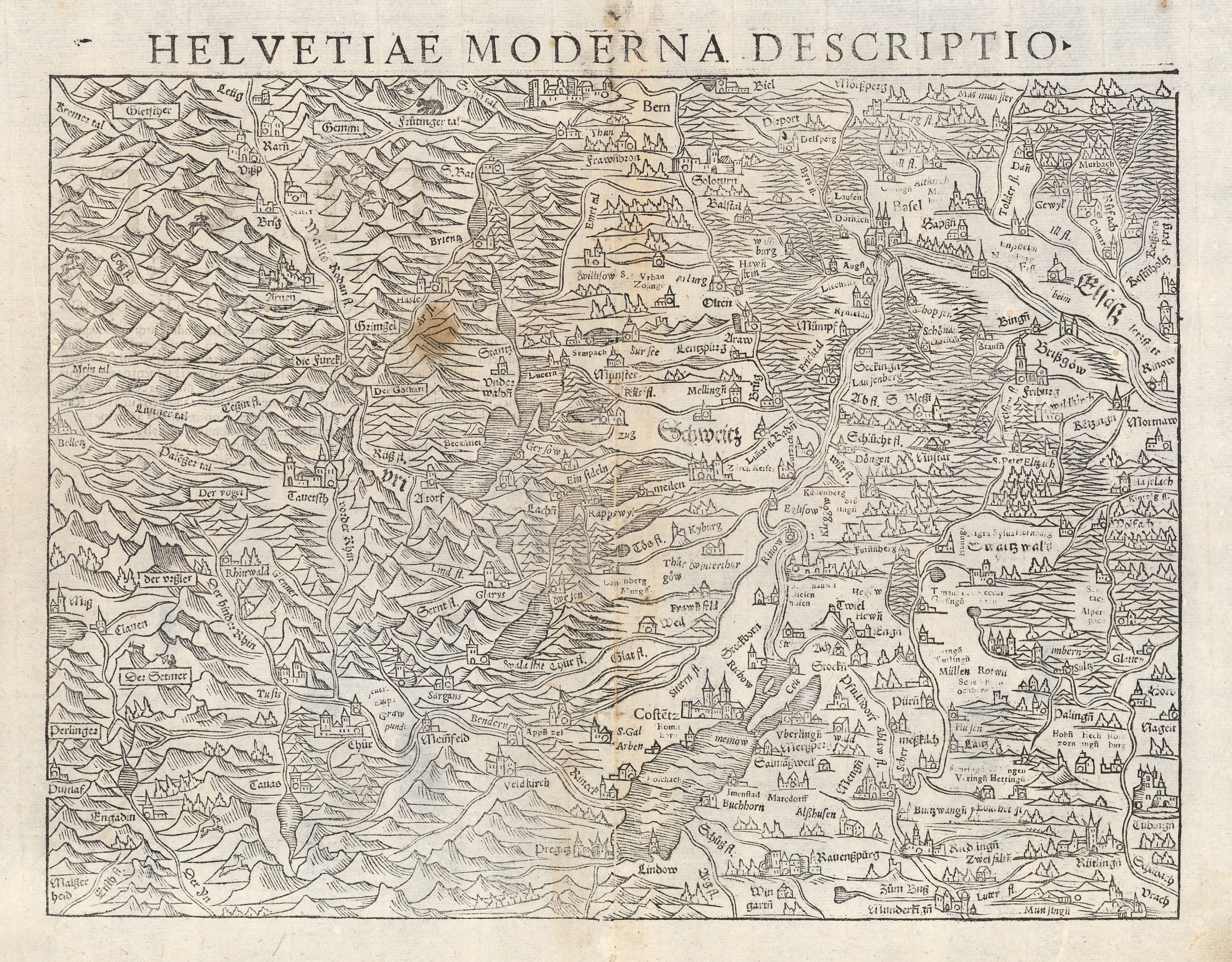
Helvetiae Moderna Descriptio
Early map of Switzerland with pictorial towns and mountain ranges. An archetypal example of 16th century wood-block printing.
SEBASTIAN MUNSTER 1489-1552
Munster was a true Renaissance polymath: a theologian, mathematician and linguist as well as an important cartographer. He is famous for his 1540 edition of Ptolemy's Geographia and his own Cosmographia, published in 1544. Both works went into several editions during Munster's lifetime and continued to be published posthumously.
Born in Ingelheim, Germany, in 1489, Munster studied first at Heidelberg under the Franciscans. There he met Martin Luther and was converted to Protestantism. Moving on to Tubingen, he learned Greek from Luther's assistant, Melanchthon, and mathematics and astronomy under Stoffler, continuing his study of the latter in Vienna. His scholastic achievements were noted by the Swiss reformer, Johann Oecolampadius, who recommended him to teach Hebrew at the University of Basle, a position he held from 1529 until his death in 1552.
Even while studying in Heidelberg, Munster had engaged in a cartographical project. His first map, of Germany, was printed in 1525. A few years later he married the widow of his printer, Adam Petri, thus cementing his partnership with the prestigious Basel printing firm. His stepson, Heinrich, subsequently published most of his work.
Of the leading cartographers of the sixteenth century, Munster had probably the biggest influence in spreading geographical knowledge around Europe. His Cosmographia contained both up-to-date maps and views and an encyclopedic range of information on the known world: it was probably one of the most widely read books of the age. He was also the first to produce separate maps of the four known continents, and the first to produce a separate map of England.
[SWAS1439]
Share
- Tumblr
Join our mailing list
* denotes required fields
We will process the personal data you have supplied to communicate with you in accordance with our Privacy Policy. You can unsubscribe or change your preferences at any time by clicking the link in our emails.
Contact
The Map House
54 Beauchamp Place,
London SW3 1NY,
United Kingdom
maps@themaphouse.com
+44 (0)20 7589 4325
![]()
Copyright © 2025 The Map House
This website uses cookies
This site uses cookies to help make it more useful to you. Please contact us to find out more about our Cookie Policy.