- All
- AFRICA
- ▪ Central Africa
- ▪ East Africa
- ▪ North Africa
- ▪ Southern Africa
- ▪ West Africa
- ▪ Atlantic Islands
- AMERICAS
-
▪ United States (USA)
- USA - East
- USA - Midwest
- USA - Northeast
- USA - Southeast
- USA - West & Southwest
- Alabama
- Alaska
- Arizona
- Arkansas
- California
- Colorado
- Connecticut
- Delaware
- Florida
- Georgia
- Hawaii
- Idaho
- Illinois
- Indiana
- Iowa
- Kansas
- Kentucky
- Louisiana
- Maine
- Maryland
- Massachusetts
- Michigan
- Minnesota
- Mississippi
- Missouri
- Montana
- Nebraska
- Nevada
- New Hampshire
- New Jersey
- New Mexico
- New York
- New York City
- North Carolina
- North Dakota
- Ohio
- Oklahoma
- Oregon
- Pennsylvania
- Rhode Island
- South Carolina
- South Dakota
- Tennessee
- Texas
- Utah
- Vermont
- Virginia
- Washington
- Washington, D.C.
- West Virginia
- Wisconsin
- Wyoming
- ▪ North America
- ▪ South America
- ▪ Caribbean
- ASIA
- ▪ East Asia
- ▪ Southeast Asia
- ▪ India & South Asia
- ▪ Middle East & Turkey
- BRITISH ISLES
- ▪ London
-
▪ England
- English Cities
- Bedfordshire
- Berkshire
- Buckinghamshire
- Cambridgeshire
- Cheshire
- Cornwall
- Cumbria
- Derbyshire
- Devon
- Dorset
- Durham
- Essex
- Gloucestershire
- Hampshire
- Herefordshire
- Hertfordshire
- Huntingdonshire
- Isle of Wight
- Kent
- Lancashire
- Leicestershire
- Lincolnshire
- Middlesex
- Norfolk
- Northamptonshire
- Northumberland
- Nottinghamshire
- Oxfordshire
- Rutland
- Shropshire
- Somerset
- Staffordshire
- Suffolk
- Surrey
- Sussex
- Warwickshire
- Wiltshire
- Worcestershire
- Yorkshire
- Yorkshire East Riding
- Yorkshire North Riding
- Yorkshire West Riding
- ▪ Ireland
- ▪ Scotland
- ▪ Wales
- EUROPE
- ▪ Austria & Switzerland
- ▪ Benelux Region
- ▪ Central & Eastern Europe
- ▪ France & Monaco
- ▪ Germany
- ▪ Greece
- ▪ Italy
- ▪ Mediterranean Sea
- ▪ Spain & Portugal
- ▪ Scandinavia & Baltics
- ▪ Russia, Ukraine & Caucasus
- OCEANIA
- ▪ Australia
- ▪ New Zealand
- ▪ Pacific Ocean & Islands
- ▪ Papua New Guinea
- POLAR
- CELESTIAL
- WORLD
- GLOBES & INSTRUMENTS
- THEMATIC
- COLLABORATIONS
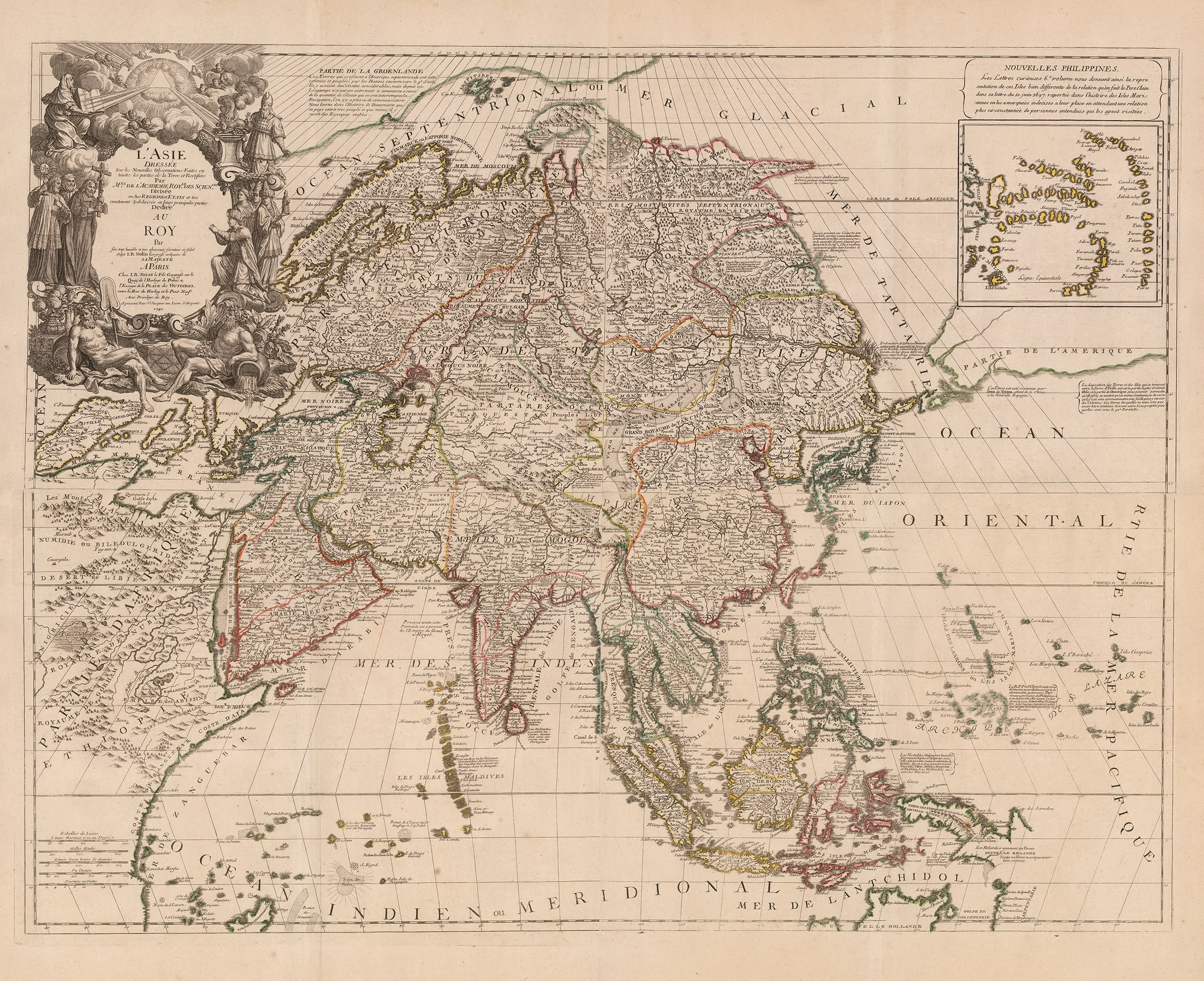
Jean Baptiste Nolin
86.4 x 114.3 cm
This is an unusual variant of Jean Baptist Nolin's separately issued wall map of Asia. Published on four sheets, it was engraved without its illustrated borders and bound within an atlas.
The Nolin firm began work in Paris in the 1680s under Jean Baptist Nolin I. A skilled engraver, his first great success was his partnership with the visiting Franciscan, Vincenzo Maria Coronelli. Nolin produced a series of highly influential and important maps of the New World and the Far East with Coronelli's name prominently displayed. It is unclear what the business relationship between the two men was but these were only maps which Coronelli issued during his stay in Paris.
Building on his success, Nolin continued to issue these maps bound in his atlases and as well as a set of spectacular separately issued wall maps of the world and continents, characterised by a series of illustrated borders which were very reminiscent of his contemporary Nicholas de Fer. This series must have been another major success for Nolin as they were issued multiple times in the 18th century with editions being recorded as late as 1762. Evidently judging by the map on offer here, they must have also come in several versions, as both as atlas maps and separate issues.
Although the map bears the date of 1740, much of the geography is based on earlier geography from such diverse sources as Coronelli, Nicholas Witsen, Guillaume de L'Isle and various Jesuit surveys many of which were again accessed and used by Coronelli.
One of the most extraordinary features is the naming of the body of water north of Japan. This nomenclature is a matter of controversy to this day, with some maps naming it the Sea or Gulf of Korea while others name it the Sea of Japan; Nolin uses both names which is extremely rare if not unique; the addition of the Gulf of Korea may have been sourced from de L'Isle's 1723 map of Asia, which also may have been the source for the shape of the Peninsula. Arabia, despite its distortion and the Indian sub-continent were sourced from Sanson while Tartary was based on the extraordinary six sheet map published by that archetypal merchant adventurer Nicholaes Witsen in 1692 and which is responsible for that peculiar spit of land on the northeast coast of Asia which is known as the Witsen Peninsula. One of the great advances of Witsen's map was his access to and compilation of several maps and reports from expeditions sponsored by Peter the Great and undertaken by groups of Cossacks. These included charting the course of the Amur River and an attempt to find a Northeast Passage. The Caspian Sea does not seem to have benefited from the manuscript maps sent by the Russian Academy of Sciences to its counterparts in the Paris, with a very indistinct delineation although it is correctly aligned north to South, unlike many of its counterparts. Nova Zembla is connected to the mainland while Greenland is grossly distorted.
A great deal more could be said about the geography of this map but one final feature that should be highlighted is the position of North America and its justification with an almost land bridge between the east coast of Asia and the west coast. This involves the mapping of several phantom islands, many unnamed but also including the stalwart Company's Land which was a regular feature on maps from the 1650s onwards after a report from Maarten de Vries's voyage which purportedly saw a large coastline in the North Pacific and which had been claimed by the Dutch East India Company. This bridge is anchored on the perception that Hokkaido and Sakhalin are one peninsula of the East coast of Asia.
As our example was once an atlas map, it is in remarkably good condition and beautiful original hand colour. TUBE [AS1092]
- X
- Tumblr
Join our mailing list
* denotes required fields
We will process the personal data you have supplied to communicate with you in accordance with our Privacy Policy. You can unsubscribe or change your preferences at any time by clicking the link in our emails.
Contact
The Map House
54 Beauchamp Place,
London SW3 1NY,
United Kingdom
maps@themaphouse.com
+44 (0)20 7589 4325
![]()
This website uses cookies
This site uses cookies to help make it more useful to you. Please contact us to find out more about our Cookie Policy.
Join our mailing list
* denotes required fields
We will process the personal data you have supplied to communicate with you in accordance with our Privacy Policy. You can unsubscribe or change your preferences at any time by clicking the link in our emails.