- All
- AFRICA
- ▪ Central Africa
- ▪ East Africa
- ▪ North Africa
- ▪ Southern Africa
- ▪ West Africa
- ▪ Atlantic Islands
- AMERICAS
-
▪ United States (USA)
- USA - East
- USA - Midwest
- USA - Northeast
- USA - Southeast
- USA - West & Southwest
- Alabama
- Alaska
- Arizona
- Arkansas
- California
- Colorado
- Connecticut
- Delaware
- Florida
- Georgia
- Hawaii
- Idaho
- Illinois
- Indiana
- Iowa
- Kansas
- Kentucky
- Louisiana
- Maine
- Maryland
- Massachusetts
- Michigan
- Minnesota
- Mississippi
- Missouri
- Montana
- Nebraska
- Nevada
- New Hampshire
- New Jersey
- New Mexico
- New York
- New York City
- North Carolina
- North Dakota
- Ohio
- Oklahoma
- Oregon
- Pennsylvania
- Rhode Island
- South Carolina
- South Dakota
- Tennessee
- Texas
- Utah
- Vermont
- Virginia
- Washington
- Washington, D.C.
- West Virginia
- Wisconsin
- Wyoming
- ▪ North America
- ▪ South America
- ▪ Caribbean
- ASIA
- ▪ East Asia
- ▪ Southeast Asia
- ▪ India & South Asia
- ▪ Middle East & Turkey
- BRITISH ISLES
- ▪ London
-
▪ England
- English Cities
- Bedfordshire
- Berkshire
- Buckinghamshire
- Cambridgeshire
- Cheshire
- Cornwall
- Cumbria
- Derbyshire
- Devon
- Dorset
- Durham
- Essex
- Gloucestershire
- Hampshire
- Herefordshire
- Hertfordshire
- Huntingdonshire
- Isle of Wight
- Kent
- Lancashire
- Leicestershire
- Lincolnshire
- Middlesex
- Norfolk
- Northamptonshire
- Northumberland
- Nottinghamshire
- Oxfordshire
- Rutland
- Shropshire
- Somerset
- Staffordshire
- Suffolk
- Surrey
- Sussex
- Warwickshire
- Wiltshire
- Worcestershire
- Yorkshire
- Yorkshire East Riding
- Yorkshire North Riding
- Yorkshire West Riding
- ▪ Ireland
- ▪ Scotland
- ▪ Wales
- EUROPE
- ▪ Austria & Switzerland
- ▪ Benelux Region
- ▪ Central & Eastern Europe
- ▪ France & Monaco
- ▪ Germany
- ▪ Greece
- ▪ Italy
- ▪ Mediterranean Sea
- ▪ Spain & Portugal
- ▪ Scandinavia & Baltics
- ▪ Russia, Ukraine & Caucasus
- OCEANIA
- ▪ Australia
- ▪ New Zealand
- ▪ Pacific Ocean & Islands
- ▪ Papua New Guinea
- POLAR
- CELESTIAL
- WORLD
- GLOBES & INSTRUMENTS
- THEMATIC
- COLLABORATIONS
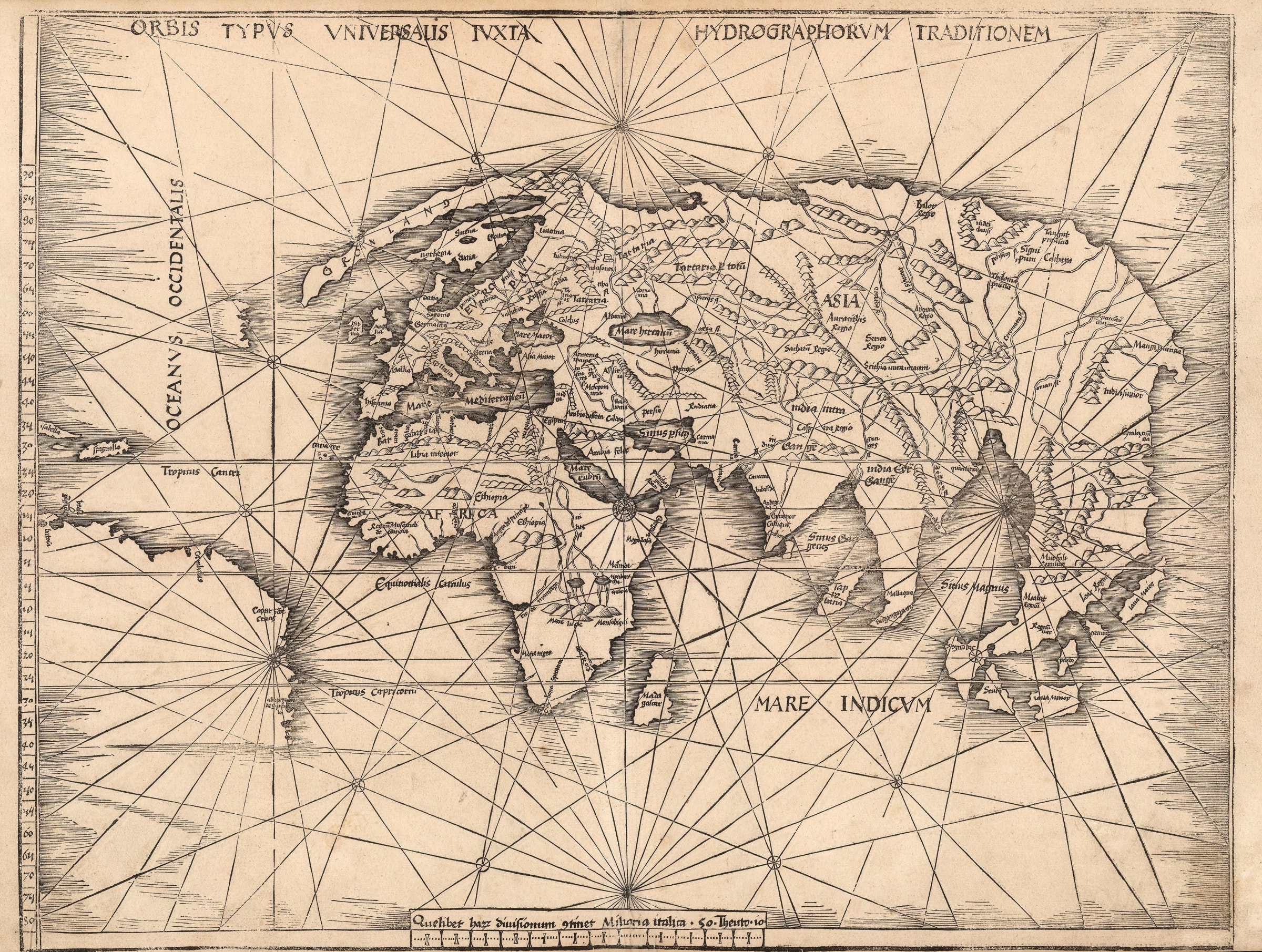
Martin Waldseemüller
45 x 58 cm
Waldseemüller’s innovation was to add a “Supplementum”, or section of twenty “modern” maps to the twenty seven maps traditional to a Geographia. This Supplementum widened the scope of the Geographia, and accounted for the extraordinary geographical advances made during the early Age of Discovery.
The project had a difficult development: work is believed to have begun c.1505, but progress was slowed by the inclusion of the twenty new maps, Waldseemüller’s engagement as a lecturer in cosmography, and the death of his patron, Duke Renee II of Lorraine, in 1508. Waldseemüller's partner in the project, Matthias Ringmann, also died in 1511. Therefore, it was not until 1513 that the volume was finally issued by the publisher, Johann Schott. By then, Waldseemüller had left the project and his work as the compiler and supervisor of the maps initially went uncredited. Despite these difficulties, the importance of Waldseemüller’s work was rapidly recognised and this edition became an enormously influential geographical compendium for decades. Waldseemüller is believed to have lived to see a second edition of the work issued in 1520, although he died shortly after, either in the same year or in 1521.
This map of the world, the first in the Supplementum, is a radical departure from the Ptolemaic model. It is the third commercially available printed map to show the discovery of the New World, depicted here as a large, unnamed landmass in the region of Brazil, together with two islands representing Cuba and Hispaniola. There is also a small coastline in the Atlantic which is unlabelled and whose geographical identity is unclear. In the text of the volume, a reference was made that the New World discoveries were derived from the observations made by an Admiral. This has led this map to be called “The Admiral’s Map” and it is often associated with Christopher Columbus, the “Great Admiral of the Ocean”. However, there has been considerable academic debate about the identity of this Admiral or even if he existed.
Certainly the geographical shapes of the New World discoveries owe more to the descriptions of Amerigo Vespucci in Brazil and the Portuguese Corte de Real brothers or Joao Fernandez for the mysterious coastline further north. Early Portuguese voyages would also have been the sources for the outline of Africa and the newly drawn outlines of Arabia, the Indian sub-continent and the Malay Peninsula although there is still confusion between it and the “peninsula” of China.
There have been changes in the cartography of western Europe, with the shape of the United Kingdom substantially altered from its Ptolemaic fore bearer, greater detail in Scandinavia and the novel theory that Greenland was peninsula attached to north western Europe running parallel to Scandinavia.
Aesthetically, the map eschews the traditional Ptolemaic wind heads but instead differentiates itself with a multitude of rhumb lines, adding a claim that it is the first commercially available printed sea chart.
The importance of Waldseemüller’s map cannot be overstated. It is often cited as the first “modern” map of the world. Framed.
[WLD4278]
Publications
Shirley, 35- X
- Tumblr
Join our mailing list
* denotes required fields
We will process the personal data you have supplied to communicate with you in accordance with our Privacy Policy. You can unsubscribe or change your preferences at any time by clicking the link in our emails.
Contact
The Map House
54 Beauchamp Place,
London SW3 1NY,
United Kingdom
maps@themaphouse.com
+44 (0)20 7589 4325
![]()
This website uses cookies
This site uses cookies to help make it more useful to you. Please contact us to find out more about our Cookie Policy.
Join our mailing list
* denotes required fields
We will process the personal data you have supplied to communicate with you in accordance with our Privacy Policy. You can unsubscribe or change your preferences at any time by clicking the link in our emails.