- All
- AFRICA
- ▪ Central Africa
- ▪ East Africa
- ▪ North Africa
- ▪ Southern Africa
- ▪ West Africa
- ▪ Atlantic Islands
- AMERICAS
-
▪ United States (USA)
- USA - East
- USA - Midwest
- USA - Northeast
- USA - Southeast
- USA - West & Southwest
- Alabama
- Alaska
- Arizona
- Arkansas
- California
- Colorado
- Connecticut
- Delaware
- Florida
- Georgia
- Hawaii
- Idaho
- Illinois
- Indiana
- Iowa
- Kansas
- Kentucky
- Louisiana
- Maine
- Maryland
- Massachusetts
- Michigan
- Minnesota
- Mississippi
- Missouri
- Montana
- Nebraska
- Nevada
- New Hampshire
- New Jersey
- New Mexico
- New York
- New York City
- North Carolina
- North Dakota
- Ohio
- Oklahoma
- Oregon
- Pennsylvania
- Rhode Island
- South Carolina
- South Dakota
- Tennessee
- Texas
- Utah
- Vermont
- Virginia
- Washington
- Washington, D.C.
- West Virginia
- Wisconsin
- Wyoming
- ▪ North America
- ▪ South America
- ▪ Caribbean
- ASIA
- ▪ East Asia
- ▪ Southeast Asia
- ▪ India & South Asia
- ▪ Middle East & Turkey
- BRITISH ISLES
- ▪ London
-
▪ England
- English Cities
- Bedfordshire
- Berkshire
- Buckinghamshire
- Cambridgeshire
- Cheshire
- Cornwall
- Cumbria
- Derbyshire
- Devon
- Dorset
- Durham
- Essex
- Gloucestershire
- Hampshire
- Herefordshire
- Hertfordshire
- Huntingdonshire
- Isle of Wight
- Kent
- Lancashire
- Leicestershire
- Lincolnshire
- Middlesex
- Norfolk
- Northamptonshire
- Northumberland
- Nottinghamshire
- Oxfordshire
- Rutland
- Shropshire
- Somerset
- Staffordshire
- Suffolk
- Surrey
- Sussex
- Warwickshire
- Wiltshire
- Worcestershire
- Yorkshire
- Yorkshire East Riding
- Yorkshire North Riding
- Yorkshire West Riding
- ▪ Ireland
- ▪ Scotland
- ▪ Wales
- EUROPE
- ▪ Austria & Switzerland
- ▪ Benelux Region
- ▪ Central & Eastern Europe
- ▪ France & Monaco
- ▪ Germany
- ▪ Greece
- ▪ Italy
- ▪ Mediterranean Sea
- ▪ Spain & Portugal
- ▪ Scandinavia & Baltics
- ▪ Russia, Ukraine & Caucasus
- OCEANIA
- ▪ Australia
- ▪ New Zealand
- ▪ Pacific Ocean & Islands
- ▪ Papua New Guinea
- POLAR
- CELESTIAL
- WORLD
- GLOBES & INSTRUMENTS
- THEMATIC
- COLLABORATIONS
Cornelis & Justus Danckerts
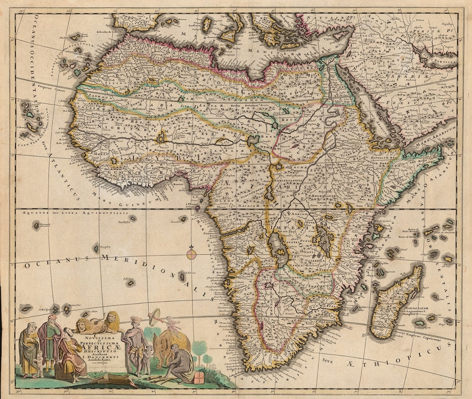
Africa, 1699 c.
19 ½ x 23 in
50 x 58 cm
50 x 58 cm
AFR5321
£ 1,950.00
Cornelis & Justus Danckerts, Africa, 1699 c.
Sold
%3Cdiv%20class%3D%22artist%22%3ECornelis%20%26%20Justus%20Danckerts%3C/div%3E%3Cdiv%20class%3D%22title_and_year%22%3E%3Cspan%20class%3D%22title_and_year_title%22%3EAfrica%3C/span%3E%2C%20%3Cspan%20class%3D%22title_and_year_year%22%3E1699%20c.%3C/span%3E%3C/div%3E%3Cdiv%20class%3D%22dimensions%22%3E19%20%C2%BD%20x%2023%20in%3Cbr/%3E%0A50%20x%2058%20cm%3C/div%3E
Novisima et Perfectissma Africae By 1699 it was just the coast of Africa that had been explored by Europeans as slave trafficking and merchant companies required only coastal bases...
Novisima et Perfectissma Africae
By 1699 it was just the coast of Africa that had been explored by Europeans as slave trafficking and merchant companies required only coastal bases to trade. The geographical information that had been brought back from these traders and sailors makes much of the mapping of ports and shorelines accurate. It is impossible though for European cartographers and engravers to have had much idea of Africa’s interior. For this reason detail within the continent must be mainly regarded as fictional. In the decorative cartouche figures and animals can be seen flanking the title. Two lions, allegories of Africa, sit upon a pediment. The lion to the right lounges calmly upon paws, head turned from the African natives and their elephant. Its partner lays crouched, face fierce, and ready to pounce upon the Europeans that are talking amongst themselves to the left of the cartouche. Betz describes this as the First State, Variant A, before the later re-working of the plate. [Betz: The Mapping of Africa: 168.1.A]. [AFR5321]
By 1699 it was just the coast of Africa that had been explored by Europeans as slave trafficking and merchant companies required only coastal bases to trade. The geographical information that had been brought back from these traders and sailors makes much of the mapping of ports and shorelines accurate. It is impossible though for European cartographers and engravers to have had much idea of Africa’s interior. For this reason detail within the continent must be mainly regarded as fictional. In the decorative cartouche figures and animals can be seen flanking the title. Two lions, allegories of Africa, sit upon a pediment. The lion to the right lounges calmly upon paws, head turned from the African natives and their elephant. Its partner lays crouched, face fierce, and ready to pounce upon the Europeans that are talking amongst themselves to the left of the cartouche. Betz describes this as the First State, Variant A, before the later re-working of the plate. [Betz: The Mapping of Africa: 168.1.A]. [AFR5321]
Share
- Tumblr
Join our mailing list
* denotes required fields
We will process the personal data you have supplied to communicate with you in accordance with our Privacy Policy. You can unsubscribe or change your preferences at any time by clicking the link in our emails.
Contact
The Map House
54 Beauchamp Place,
London SW3 1NY,
United Kingdom
maps@themaphouse.com
+44 (0)20 7589 4325

Copyright © 2025 The Map House
This website uses cookies
This site uses cookies to help make it more useful to you. Please contact us to find out more about our Cookie Policy.

