- All
- AFRICA
- ▪ Central Africa
- ▪ East Africa
- ▪ North Africa
- ▪ Southern Africa
- ▪ West Africa
- ▪ Atlantic Islands
- AMERICAS
-
▪ United States (USA)
- USA - East
- USA - Midwest
- USA - Northeast
- USA - Southeast
- USA - West & Southwest
- Alabama
- Alaska
- Arizona
- Arkansas
- California
- Colorado
- Connecticut
- Delaware
- Florida
- Georgia
- Hawaii
- Idaho
- Illinois
- Indiana
- Iowa
- Kansas
- Kentucky
- Louisiana
- Maine
- Maryland
- Massachusetts
- Michigan
- Minnesota
- Mississippi
- Missouri
- Montana
- Nebraska
- Nevada
- New Hampshire
- New Jersey
- New Mexico
- New York
- New York City
- North Carolina
- North Dakota
- Ohio
- Oklahoma
- Oregon
- Pennsylvania
- Rhode Island
- South Carolina
- South Dakota
- Tennessee
- Texas
- Utah
- Vermont
- Virginia
- Washington
- Washington, D.C.
- West Virginia
- Wisconsin
- Wyoming
- ▪ North America
- ▪ South America
- ▪ Caribbean
- ASIA
- ▪ East Asia
- ▪ Southeast Asia
- ▪ India & South Asia
- ▪ Middle East & Turkey
- BRITISH ISLES
- ▪ London
-
▪ England
- English Cities
- Bedfordshire
- Berkshire
- Buckinghamshire
- Cambridgeshire
- Cheshire
- Cornwall
- Cumbria
- Derbyshire
- Devon
- Dorset
- Durham
- Essex
- Gloucestershire
- Hampshire
- Herefordshire
- Hertfordshire
- Huntingdonshire
- Isle of Wight
- Kent
- Lancashire
- Leicestershire
- Lincolnshire
- Middlesex
- Norfolk
- Northamptonshire
- Northumberland
- Nottinghamshire
- Oxfordshire
- Rutland
- Shropshire
- Somerset
- Staffordshire
- Suffolk
- Surrey
- Sussex
- Warwickshire
- Wiltshire
- Worcestershire
- Yorkshire
- Yorkshire East Riding
- Yorkshire North Riding
- Yorkshire West Riding
- ▪ Ireland
- ▪ Scotland
- ▪ Wales
- EUROPE
- ▪ Austria & Switzerland
- ▪ Benelux Region
- ▪ Central & Eastern Europe
- ▪ France & Monaco
- ▪ Germany
- ▪ Greece
- ▪ Italy
- ▪ Mediterranean Sea
- ▪ Spain & Portugal
- ▪ Scandinavia & Baltics
- ▪ Russia, Ukraine & Caucasus
- OCEANIA
- ▪ Australia
- ▪ New Zealand
- ▪ Pacific Ocean & Islands
- ▪ Papua New Guinea
- POLAR
- CELESTIAL
- WORLD
- GLOBES & INSTRUMENTS
- THEMATIC
- COLLABORATIONS
Daniel Veelward
43 x 49 cm
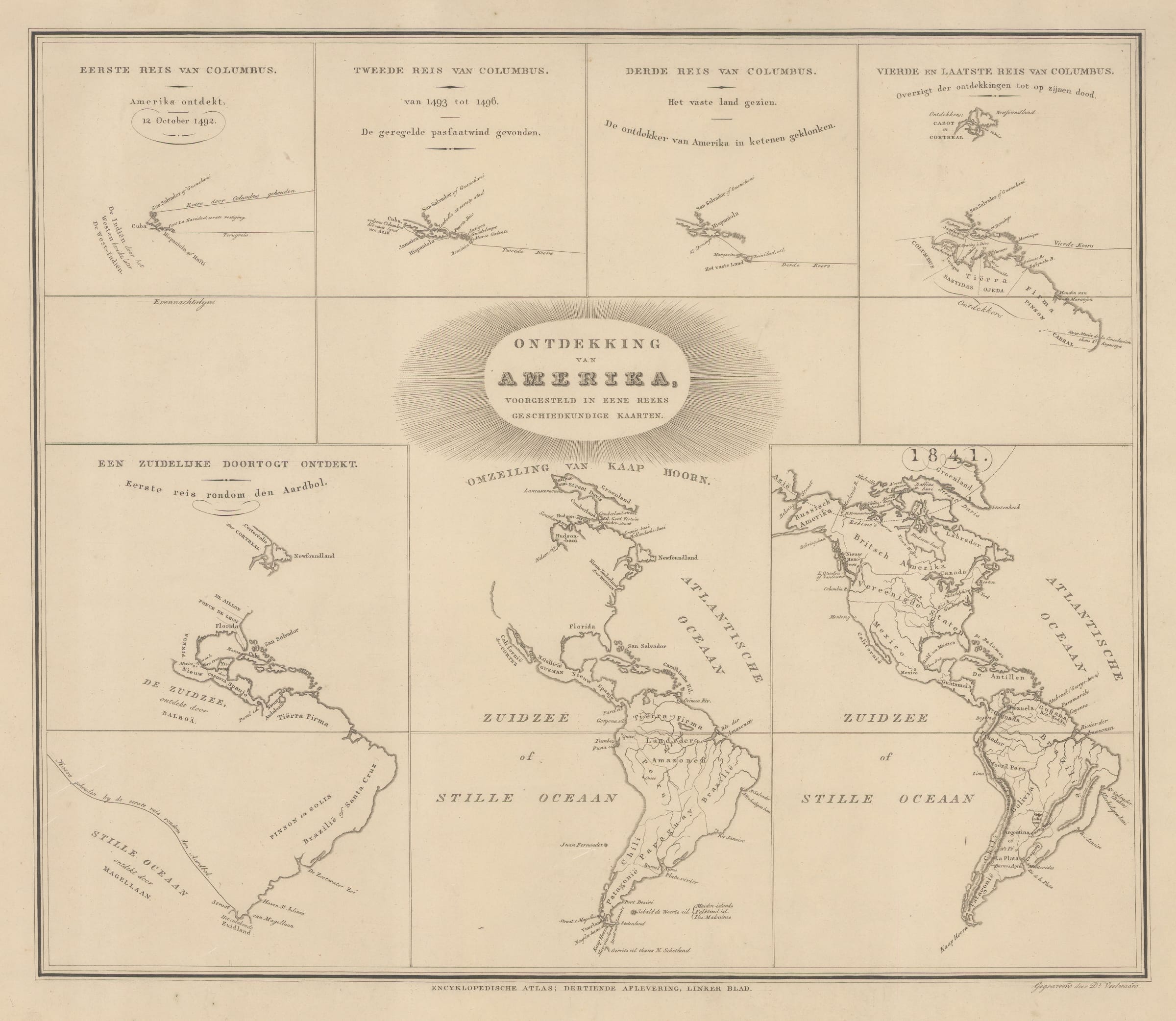
This rare Dutch map illustrates the gradual discovery of the Americas by the Europeans from Columbus's first voyage in 1492 up to 1841 through a series of 7 maps, each slightly larger and more detailed than the one before. Translated from Dutch, the captions for each map read [from top left to bottom right]...
1. First voyage of Columbus. America discovered, 12 October 1492
2. Second voyage of Columbus. From 1493-1496. Discovered the regular trade wind.
3. Third voyage of Columbus. The mainland sighted. The discoverer of America locked in chains [a reference to Columbus's brief imprisonment for cruelty to the native people of Hispaniola]
4. Fourth and final voyage of Columbus. Overview of his discoveries up to his death. [1502-4]
5. A southern passage discovered. First circumnavigation of the globe. [1520]
6. The rounding of Cape Horn. [1616]
7. 1841
The first four maps focus specifically on the discoveries of Christopher Columbus, so only the Caribbean and parts of northern South America are shown, along with a tiny portion of Labrador according to John Cabot.
The fifth map, which shows the discovery of the Strait of Magellan in 1520, is significantly improved. Spanish discoveries in Mexico, Florida, and Brazil have been added, though the Pacific coast of South America is entirely uncharted, as are the east and west coasts of North America. Vasco Núñez de Balboa's discovery of the Pacific Ocean is recognized and so are the explorations of Ponce de Leon in Florida and Lucas Vázquez de Ayllón in the Carolinas.
The sixth map, showing the rounding of Cape Horn by Willem Schouten in 1616, includes the complete outline of South America, a respectable coastline for the Eastern USA, California as an island, and an unexplored Pacific Northwest.
Lastly, map number 7, the "contemporary" map, shows an almost complete outline of the Americas, though the modern borders between Mexico, the USA, and Canada have not yet been established, and Alaska is still claimed by Russia.
This fascinating diagram was published in the rare Encyklopedische Atlas by Brand Eschauzier. Both the atlas and this specific map are rarely offered for sale.
[AMER1247] (BC)
- X
- Tumblr
Join our mailing list
* denotes required fields
We will process the personal data you have supplied to communicate with you in accordance with our Privacy Policy. You can unsubscribe or change your preferences at any time by clicking the link in our emails.
Contact
The Map House
54 Beauchamp Place,
London SW3 1NY,
United Kingdom
maps@themaphouse.com
+44 (0)20 7589 4325
![]()
This website uses cookies
This site uses cookies to help make it more useful to you. Please contact us to find out more about our Cookie Policy.
Join our mailing list
* denotes required fields
We will process the personal data you have supplied to communicate with you in accordance with our Privacy Policy. You can unsubscribe or change your preferences at any time by clicking the link in our emails.