-
 Jacques-Nicolas Bellin, Tokyo, 1752£ 545.00
 -
J.B.B. D'Anville, China, Korea, Japan, the Philippines, and Southeast Asia, 1752£ 1,500.00
-
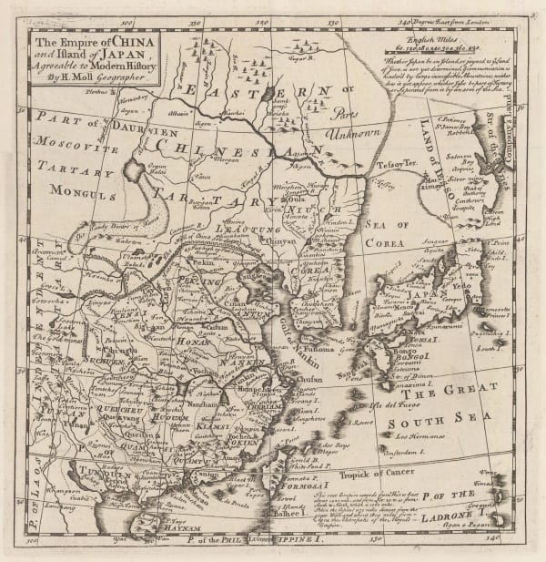
Herman Moll, The Empire of China and the Island of Japan, 1755 c.£ 625.00
-
Jacques-Nicolas Bellin, Japan, Korea, Taiwan and coast of China, 1760 c.£ 625.00
-
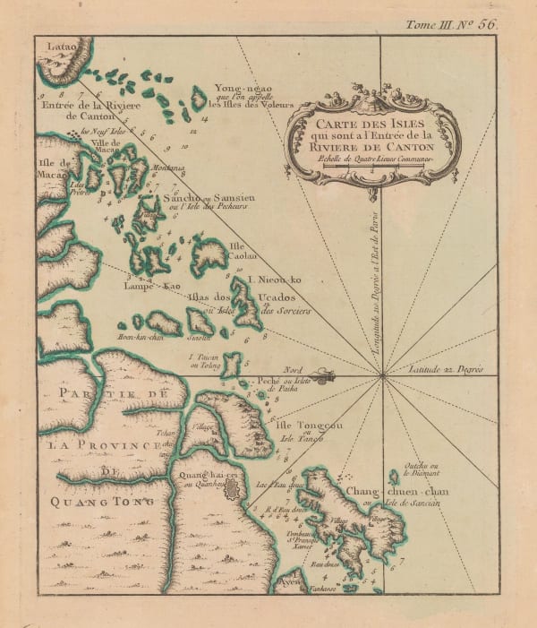
Jacques-Nicolas Bellin, Mouth of the Pearl River, 1760 c.£ 275.00
-
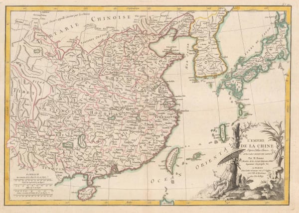
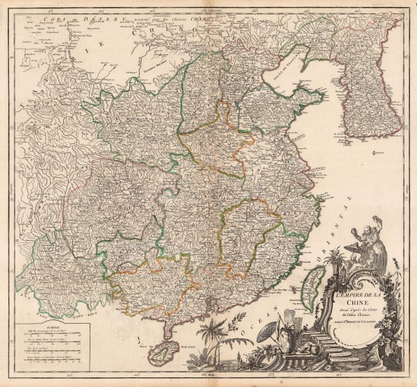
Isaac Tirion, The Empire of China, 1760 c.£ 825.00
-
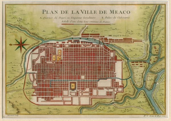
Jacques-Nicolas Bellin, Plan de la Ville Meaco, 1762£ 595.00
-
Jacques-Nicolas Bellin, Japan, 1764£ 885.00
-
Jacques-Nicolas Bellin, Mouth of the Pearl River and southern shore of China, 1764£ 195.00
-
Jacques-Nicolas Bellin, Chusan Island, 1764£ 125.00
-
Jacques-Nicolas Bellin, Fuzhou & the Min River, 1764£ 145.00
-
Jacques-Nicolas Bellin, Taiwan (Formosa), 1764£ 645.00
-
Emanuel Bowen, Detailed map of Japan, 1766£ 2,450.00
-
Rigobert Bonne, Korean Peninsula and Northern China, 1771£ 265.00
-
Jean-Baptiste de Mannevillette, One of the first commercially available charts to show Hong Kong, 1775£ 3,750.00
-
Francois Santini, China, Japan, and Korea, 1779£ 645.00
-
Rigobert Bonne, Chinese Empire, Korea, and Japan, 1780 c.£ 295.00
-
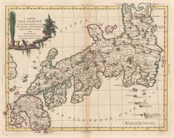
Antonio Zatta, Japan divided into six regions, 1785£ 1,650.00
-
Robert de Vaugondy, Chinese Empire, 1790 c.£ 425.00
-
Laurie & Whittle, Chart of the East China Sea, 1794£ 2,450.00
-
Laurie & Whittle, Rare chart of the Pearl River, 1794£ 4,250.00
-
Antonio Zatta, China and Japan, 1795£ 725.00
-
Sir George Staunton, Track of H.M.S. Clarence through the Zhoushan Archipelago, 1796£ 295.00
-
Sir George Staunton, Chart of the ship routes of Sir George Staunton expedition, 1796£ 725.00
-
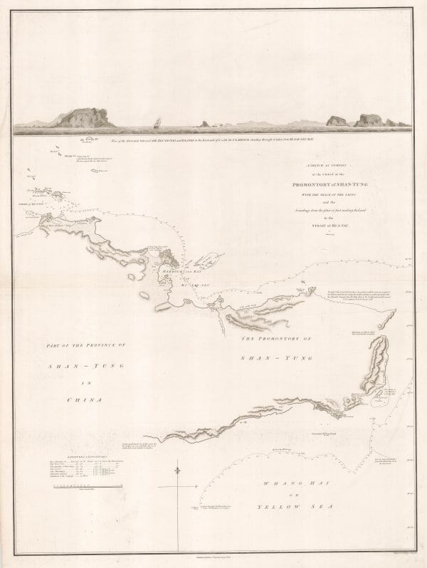
Sir George Staunton, Coast of the Shandong peninsula, 1796£ 285.00
-
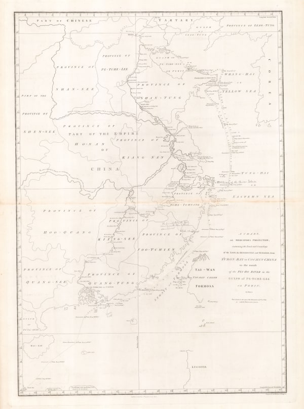
Sir George Staunton, Route map from Beijing to Hangzhou, 1796£ 985.00
-
Jean Francois de La Perouse, Chart of La Perouse's discoveries off the Pacific coast of Russia, 1797£ 220.00
-
Jean Francois de La Perouse, Chart of the coast of China, Korea, Japan, Taiwan and the Philippines, 1797£ 495.00
-
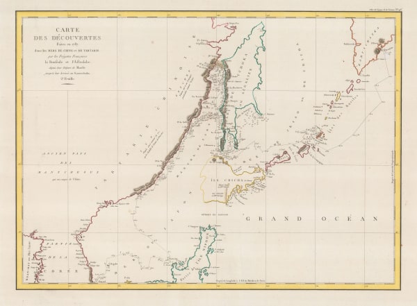
Jean Francois de La Perouse, Lapérouse's Discoveries in China, Taiwan, Japan & Korea, 1797£ 675.00
-
William Faden, Miniature map of China, Japan and Korea, 1798£ 295.00
-
Adolf Stieler, China divided into provinces, 1804£ 595.00
-
Morse and Andrews, China, 1805£ 225.00
-
Christian Louis Jose De Guignes, Chart of the mouth of the Pearl River and Macao, 1808£ 2,450.00
-
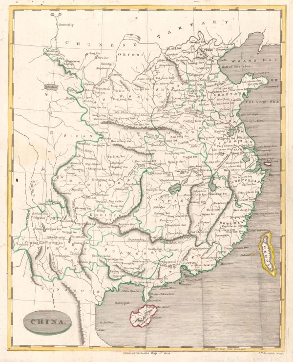
John Pinkerton, China, 1809£ 495.00
-
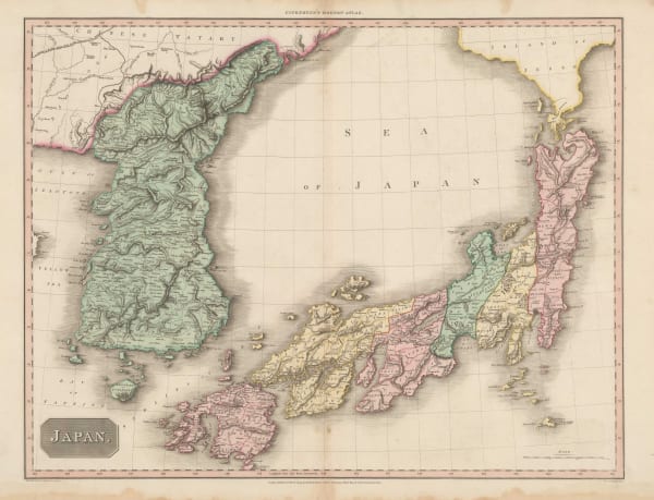
John Pinkerton, Japan, 1809£ 1,250.00
-
C.V. Lavoisne, Geographical and Historical Map of China, 1813£ 525.00
-
Bartolomeo Borghi, China, Japan, Tibet, and Mongolia, 1818£ 285.00
-
Daniel & William Lizars, China, 1820 c.£ 345.00
-
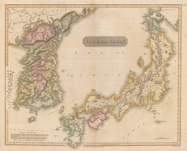
John Thomson, Korea and Japan, 1820 c.£ 1,545.00
-
Philippe Vandermaelen, China - Beijing, Tiānjīn and Hebei, 1827£ 750.00
-
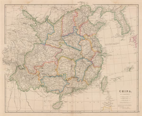
John Arrowsmith, China, 1832£ 695.00
-
Carl Weiland, China and Japan, 1832£ 345.00
-
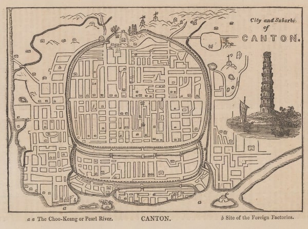
Anonymous, City and Suburbs of Canton, 1835£ 48.00
-
Alexandre Emile Lapie, Mongolia, Tibet and China, 1838£ 185.00
-
Thomas Kelly, China, 1840 c.£ 92.00
-
Anonymous, Tempo Period Map of Tokyo, 1840 c.£ 1,850.00
-
Henry Teesdale, China and Japan, 1841£ 395.00
-
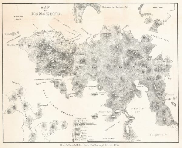
William Bernard, Map of Hong Kong, 1845£ 1,850.00
-
-
Samuel Augustus Mitchell, China, 1849£ 295.00
-
Joseph Meyer, German map of China, 1849£ 115.00
-
James Wyld, Map of China, 1850 c.£ 1,350.00
-
Gall & Inglis, Map of China and Japan, 1850 c.£ 165.00
-
John Tallis, China and Myanmar, 1851£ 395.00
-
John Tallis, Japan and Korea, 1851£ 695.00
-
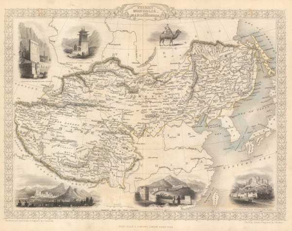
John Tallis, Tibet, Mongolia and Manchuria, 1851£ 295.00
-
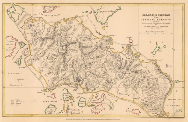
Royal Geographical Society (RGS), Island of Chusan from Official Surveys, 1853£ 85.00
-
Matthew Perry, Keelung Harbor, Taiwan, 1854£ 1,275.00
-
Royal Geographical Society (RGS), Map of the Amur and Adjacent Districts, 1858£ 225.00
-
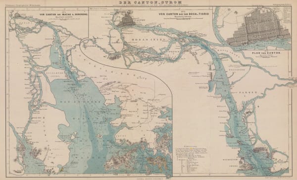
Justus Perthes, The Pearl River from Guangzhou to Hong Kong, 1858£ 595.00
-
-
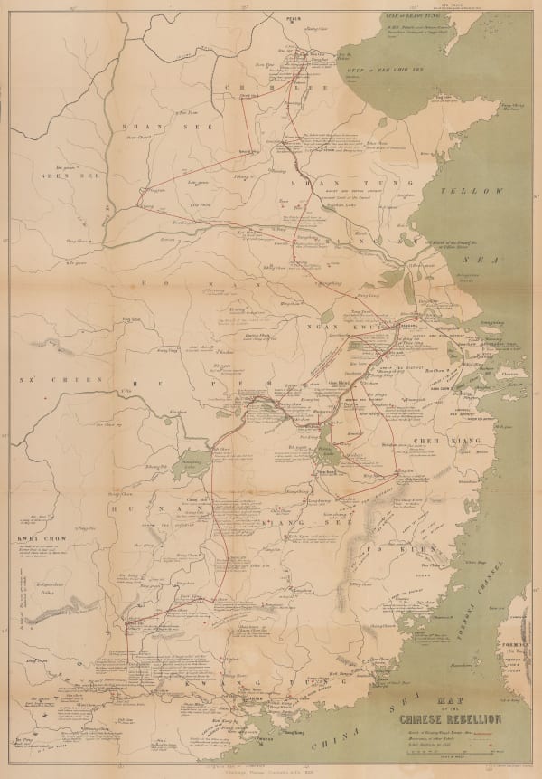
W. & A.K. Johnston, Map of the Chinese Rebellion, 1860£ 1,200.00
-
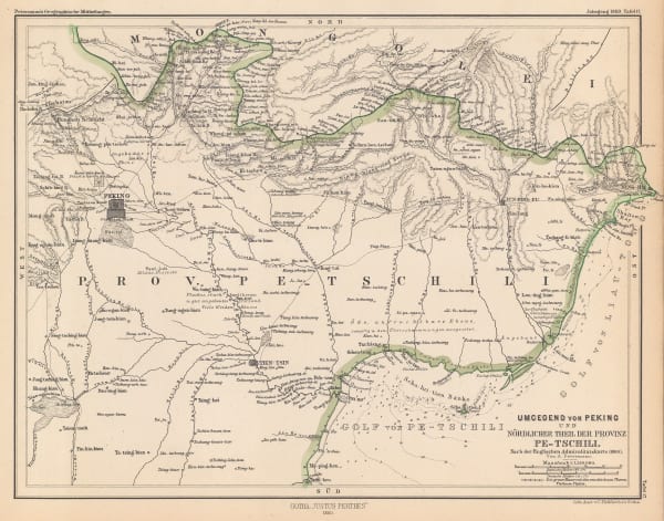
Justus Perthes, Environs of Beijing / Province of Pe-Tschili, 1860£ 82.00
-
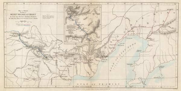
James Wyld, Allied Forces in Western China and Beijing, 1860 (c.)£ 2,950.00
-
Society for Promoting Christian Knowledge (SPCK), China, 1860 c.£ 195.00
-
John Rapkin, China and Myanmar, 1860 c.£ 175.00
-
Royal Geographical Society (RGS), Tokyo to Mount Fuji route map, 1861£ 245.00
-
Royal Geographical Society (RGS), China - The Yang-Tsze Kiang, 1862£ 375.00
-
A. Fullarton & Co., Japan, Korea, Manchuria, and the coast of Siberia, 1862£ 525.00
-
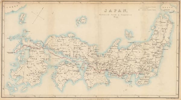
Royal Geographical Society (RGS), Japan, reduced from a Japanese map., 1862 c.£ 275.00
-
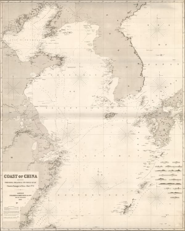
Edward Weller, Coast of China, 1863£ 125.00
-
-
James Imray, Taiwan and the North Pacific, 1863£ 2,200.00
-
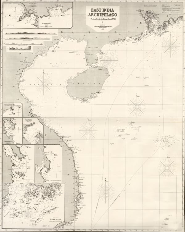
James Imray, East Indian Archipelago. (Western Route to China. Chart No. 5), 1863£ 4,950.00
-
Royal Geographical Society (RGS), Sketch map of Northern China, 1863£ 165.00
-
Royal Geographical Society (RGS), Tsushima Island, 1863£ 88.00
-
Royal Geographical Society (RGS), Sketch map of the Island of Taiwan (Formosa), 1864£ 425.00
-
Ezuya Shohachi, Washū-Nara-no-Ezu region, Japan, 1864 c.£ 395.00
-
Royal Geographical Society (RGS), Beijing (Peking), 1866£ 675.00
-
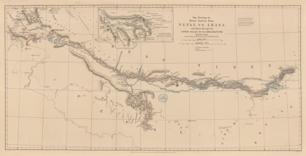
Royal Geographical Society (RGS), Map Showing the Route Survey from Nepal to Lhasa and thence through the Upper Valley of the Brahmaputra, Made by Pundit ___, 1868£ 575.00


Page
2
of 5