
In 1940 the Oberkommando der Wehrmacht [German Army High Command] drew up a series of incredibly detailed plans for Unternehmen Seelöwe [Operation Sea Lion] the invasion of Great Britain. These secret plans were only to be issued to the German officers on the very eve of the invasion hence their great rarity.
These booklets cover all aspects of the land to be conquered. There are maps of the coast and town plans as well as descriptions of every conceivable subject of interest to an occupying force. One of the most striking features is the liberal use of photographic images to familiarize the officers with significant features. These range from bridges, factories and coastal views taken from aerial photographs, and illustrations from books and magazines and even holiday snaps and postcards.

Militärgeographische Angaben über England, Südküste, [Military Geographical Information about the English South Coast], 480 pp. book, published in Berlin, 1940.
Text, photographs and maps focussing on the English South Coast bound in original paper wrappers. The photographs present a particularly incongruous sight with many of the beaches shown crowded with carefree pre-war families of holidaymakers.
 Militärgeographische Angaben über England, London, [Military Geographical Information about…London], 72pp. book, published in Berlin, 1940.
Text and aerial photographs of London highlighting potential targets such as railways, bridges, the City and docks. Other targets illustrated include the Houses of Parliament, the Tower of London and Buckingham Palace.

Stadtdurchfahrtpläne England [English Town Plans], 162pp. book, published in Berlin, 1941.
160 plans, many folding, of English towns ranging from major cities such as Manchester, Birmingham and Liverpool to such small towns as Bideford and Newton Abbot. The main roads are marked in yellow and are differentiated between major (presumably suitable for panzers and military traffic) and those described as “congested”.

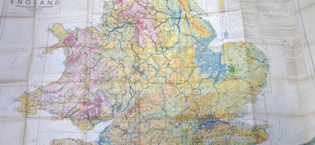
England Militärgeographische Operationskarte [Military Operations Map of England], coloured lithographed map, 100 x 135cm., published in Berlin, 1940.
This large elegantly drawn map gives an overview of the best means of moving ground forces throughout England and Wales. Land contours are clearly indicated in different colours while the width of rivers, the great barriers to movement, is drawn to scale.
These extraordinary documents are a chilling testimony to the thoroughness of the German planners and how imminent was the danger of invasion.