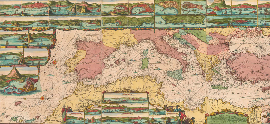
This feature on our blog is dedicated to an extraordinary collection of sea charts from the Amsterdam edition of the "Neptune Francois," the "Cartes Marines a l'Usage des Armees du Roy de Grande Bretagne," and the "Suite de Neptune Francois" published between 1693 and 1700. The whole work was issued by Pierre Mortier and is collectively cited as the finest sea chart atlas of its age.
While the charts are generally rare and very desirable, this particular set is embellished in the extraordinary colouring prevalent in Amsterdam. In its original form, this type of full body colour is very seldom seen. It was extremely expensive and time consuming to provide, resulting in a very costly incarnation of what was already a very expensive book. Even more astonishing is the survival of these examples with the colouring generally intact.
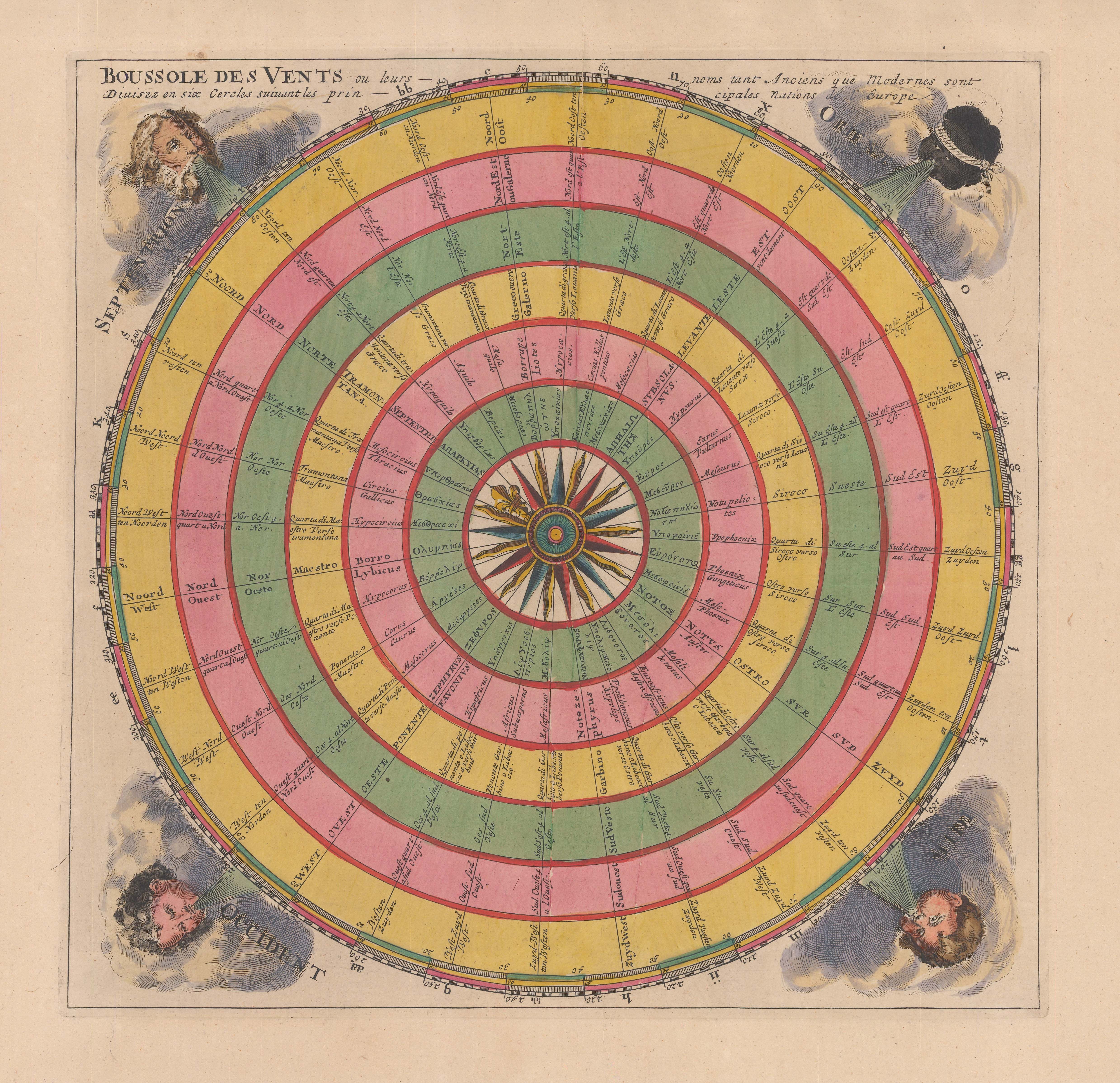
Extraordinary example of a large compass rose issued within an introduction of the "Neptune Francais". This was the Dutch edition published by Pierre Mortier in 1708 embellished with astounding full original hand colour - Ref: CELEST1274
Pierre Mortier was born in c.1661 grandson of a French couple who had immigrated to Leiden in 1625. By 1681, there is a record of him as an apprentice to a bookseller in Paris and he must have built an impressive network of contacts since his later enormous success and vast wealth was based on his connections in the city and his expertise in French books. In 1685, he was recorded as a member of the bookseller's guild in Amsterdam, having rented premises on which he put up the sign "at the city of Paris".
Unlike many of his contemporaries, Mortier appears to have been a shrewd and careful businessman as well as a highly influential bookseller. He did not specialise in maps and atlases but he was the first Amsterdam bookseller to become aware that the mantle for geographical innovation had moved from Amsterdam to Paris. Crucially, he was able to make the most of this early knowledge and rapidly began to issue maps by Sanson, Jaillot and other important French geographers some time before his competitors in Amsterdam.
His French connections came to the fore again as he became aware that the most powerful politician in France, Jean-Marie Colbert, had commissioned a grand new Atlas, to be entitled "Le Neptune Francois" as a response to the Franco-Dutch War of 1672-8. Although the French gained territory, essentially establishing a new northern border which is still current to this day, it was apparent that their Navy lacked accurate charts of the coasts of France, modern Belgium, the Netherlands and Great Britain. "Le Neptune Francois" was to correct this lack and provide important information in case there was a resumption of the conflict. The Atlas was a collaborative effort from multiple sources, including Louis XIV's Astronomer, Giovanni Domenico Cassini, local contemporaneous charts, as well as, crucially, existing naval manuscripts in the French Admiralty; Colbert was the French Minister to the Navy and oversaw a vast growth in that service. The main editor was the respected Charles Pene while the publisher was Hubert Jaillot; probably for marketing purposes, the maps in the atlas were generally attributed to "Sieur Sanson" the near legendary French royal cartographer and former geographical tutor to both Louis XIII and Louis XIV, Nicolas Sanson d'Abbeville. Even almost three decades after his death, his name was a byword for geographical authority.
It is not known if Colbert was aware of this, but Jaillot planned to publish this atlas simultaneously in Amsterdam with Pierre Mortier, as well as his own edition in Paris. Again, it is not known if Mortier contributed financially to the Paris edition but he certainly was solely responsible for the financing of the Dutch version. The first volume of the work came out in 1693, with a second volume quickly added in the same year and a third in 1700. Subsumed within work as the second volume was also the Atlas Maritimus, or the "Cartes Marines a L'Usage des Armees du Roy de Grande Bretagne," a magnificent set of charts of the English and French coasts by the Dutch artist Romeyn de Hooghe. This set is often cited as the most decorative sea charts ever published during the Dutch Golden Age. De Hooghe was an artist in the employ of William III of Britain, mostly to conduct a public relations war against William's implacable enemy Louis XIV in the form of satirical images and engravings but he also produced this set of charts as an aid for any potential new conflict between England and France.
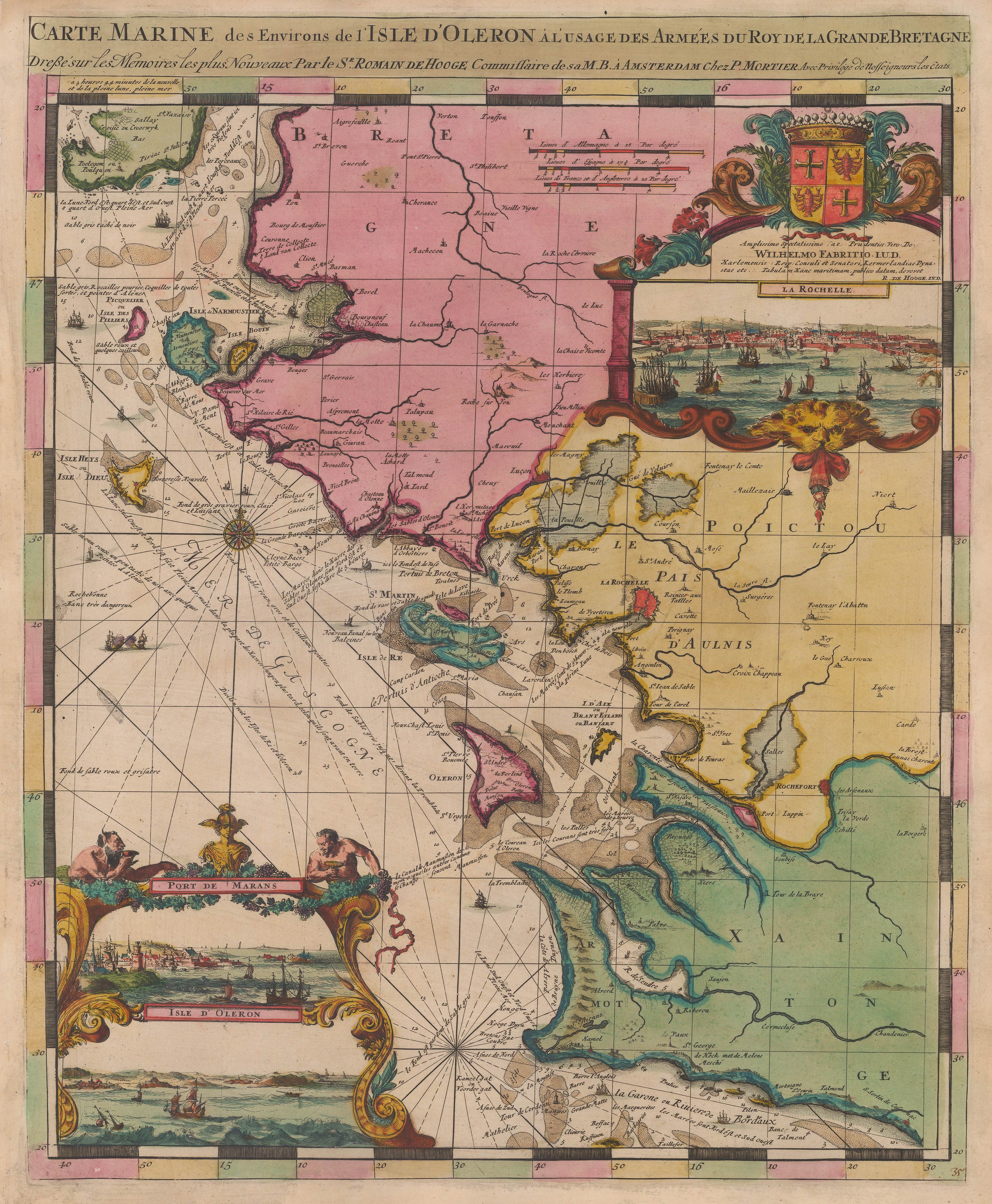
Stunning map of Romeyn de Hooghe's map of the Western coast of France, focusing on Ile d'Oleron and Isle de Ré (1708) - Ref: FR3312
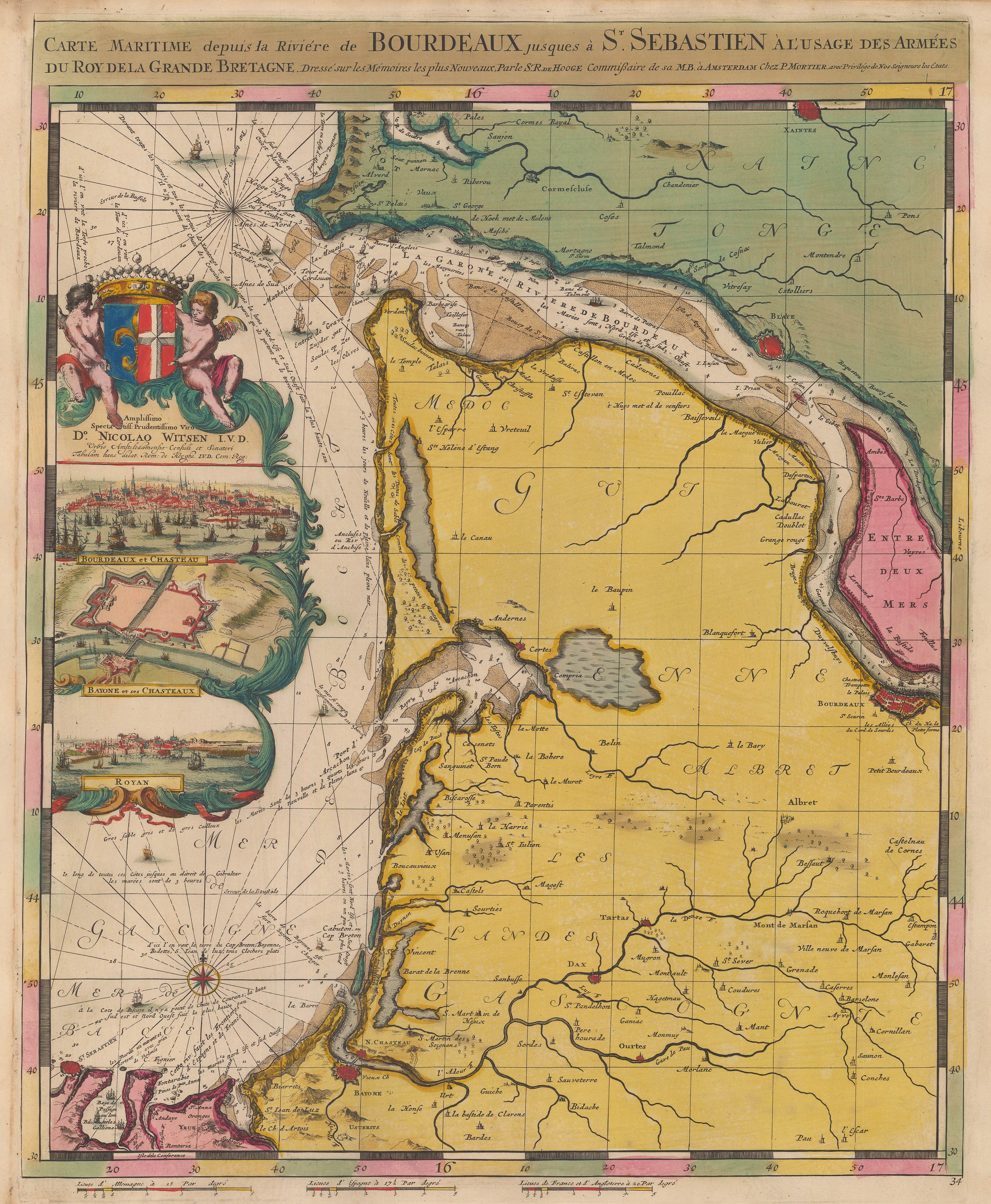
Glorious chart of southwestern France from the mouth of the Bordeaux River to St. Sebastian in northern Spain. Including inset views of Bordeaux, Bayonne and Royan (1708) - Ref: FR3311

Romeyn de Hooghe's magnificent chart of Brittany with inset panoramas of Brest, St. Malo, Conquerneau (modern day Concerneau) and St. Louis (1708) - Ref: FR3313

Romeyn de Hooghe's delightful map of eastern Brittany and western Normandy, including the Channel Islands, including inset plans and views of Mont St. Michel, Le Havre and Cherbourg (1708) - Ref: FR3314
The project was extremely successful. So much so that in Volume III, the "Suite de Neptune", Mortier had widened the purview of the atlas and incorporated maps from other parts of the world including the Far East, Africa and the New World. Contemporary records show that the final book was the most expensive chart atlas produced in Amsterdam to date. It is also clear that the work was a prestige item, to be placed in the same realm as the wall maps present in Vermeer paintings or the Atlas Major produced by the Blaeu family thirty years earlier. None of the charts were meant to be used at sea. Rather they or the atlases were to be used as references in the libraries of the wealthy.

Stunning circa 1700 sea chart of India and South East Asia with an important early outline of the Australian coast. - Ref: SEAS4836

Large, spectacular two-sheet map showing modern Thailand, Malaysia, Laos, Singapore together with the western Indonesian islands of Sumatra, Borneo and Java. (circa 1708) - Ref: SEAS4962
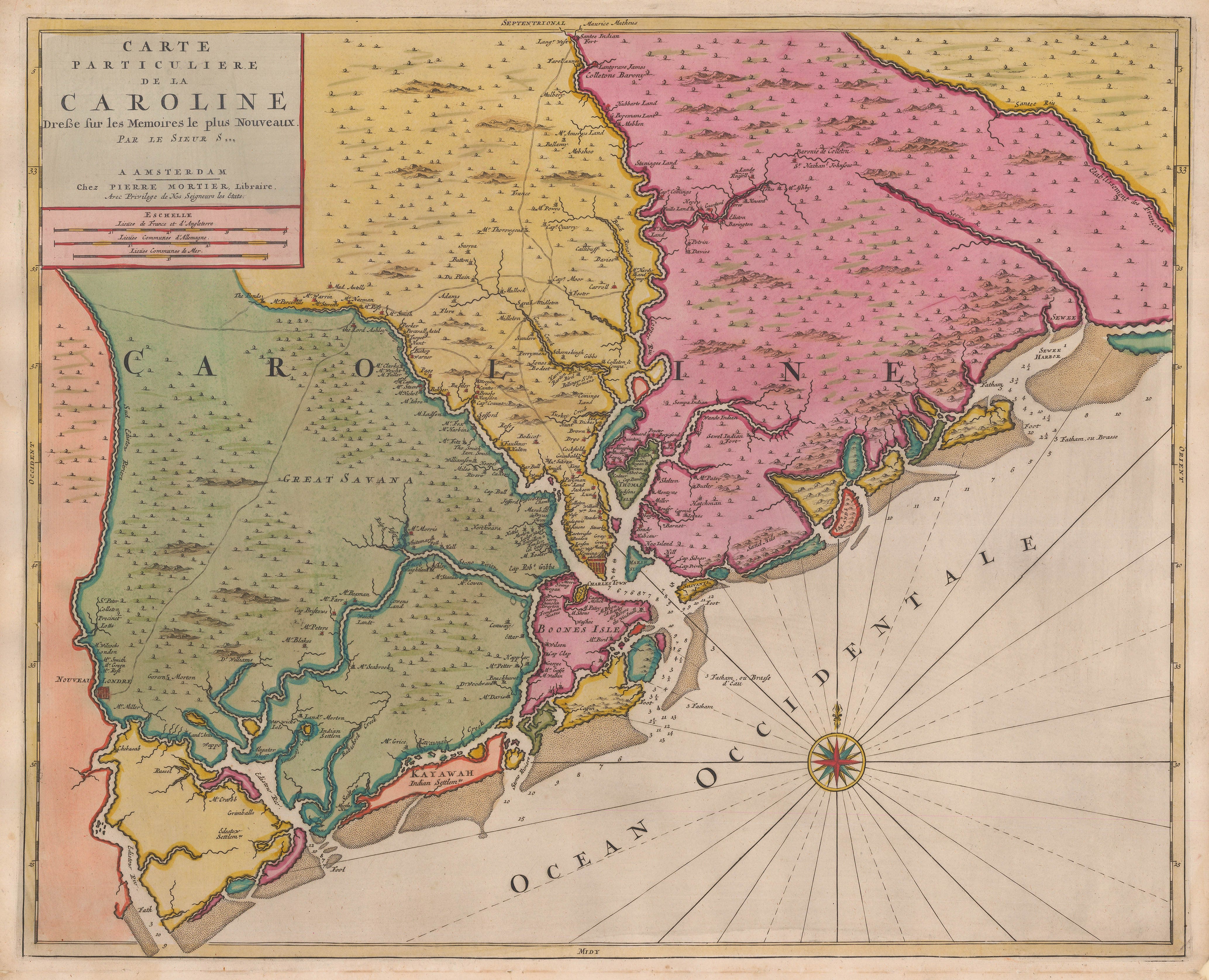
Very fine and unusual example of Mortier's important map of the area around Charleston with multiple plantation names and the early route network (1700) - Ref: USA9189
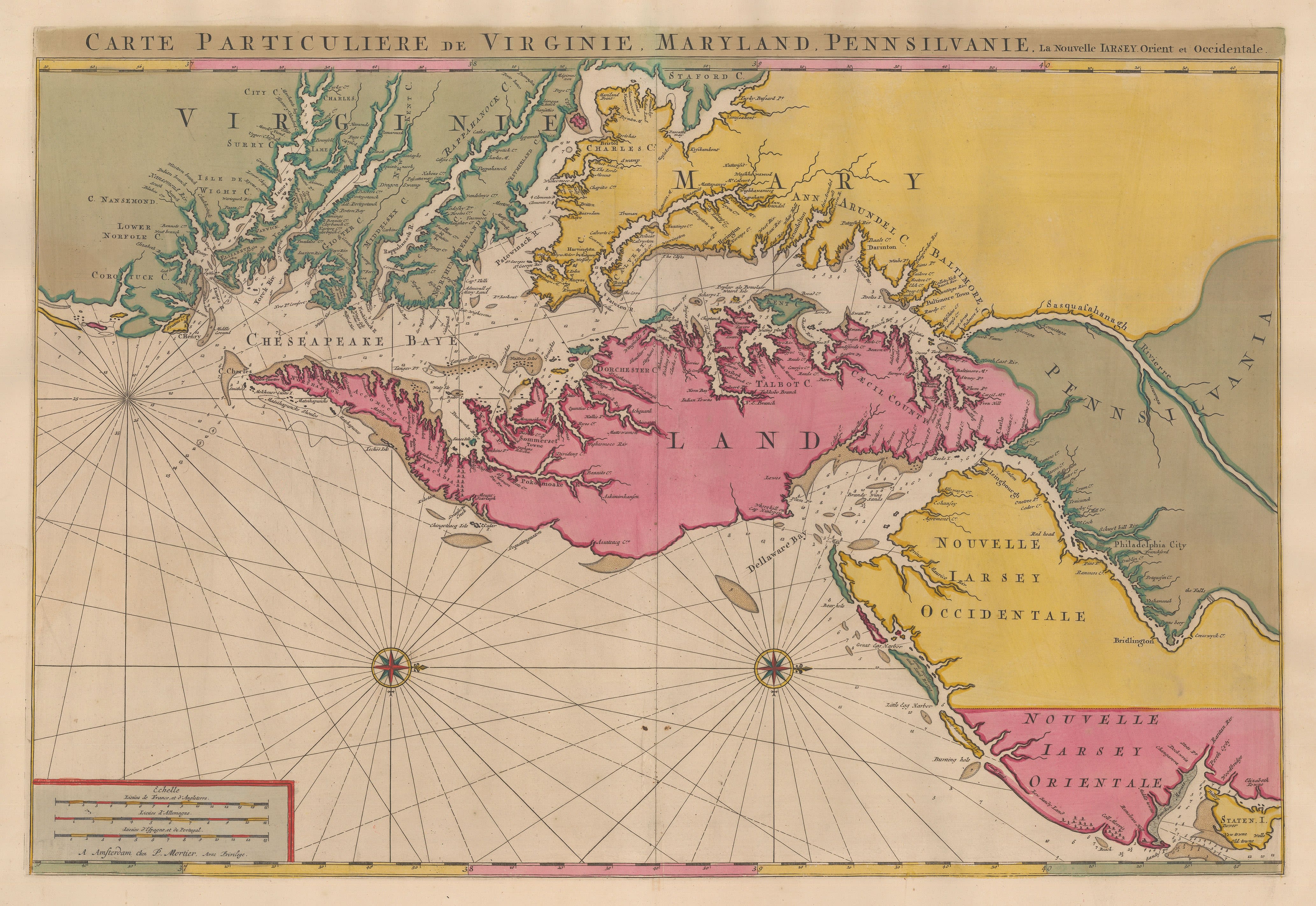
Superb example of Mortier's version of Chesapeake Bay as surveyed by Augustine Herrman with north oriented to the right. Magnificent original hand colour. (1700) - Ref: USA9191
Aesthetically, there were three versions of the work. It could be purchased with the charts uncoloured; the more usual coloured version was characterised by sparse yet striking outline colouring. Finally, the rarest and most luxurious version was in full original wash colour primarily in bright green, yellow, pink and red pigments. It is in this version that it can be seen why this book has been called the most expensive chart atlas produced in Amsterdam to that time. The full wash colour is notoriously fragile and very rarely survives to the modern day without oxidising; this causes the green to turn brown and also often leaves an imprint of its outline on the opposing page, causing a stain, also known as offsetting.
However, as seen on the examples in this article, when one is fortunate to find a group which has not been affected by the offsetting and with the colour still fresh, the results are absolutely breath taking.
Enjoy.
If you have any questions or would like to enquire as to the availability of these maps or see more of Mortier's work, please do not hesitate to email us -maps@themaphouse.com.