-
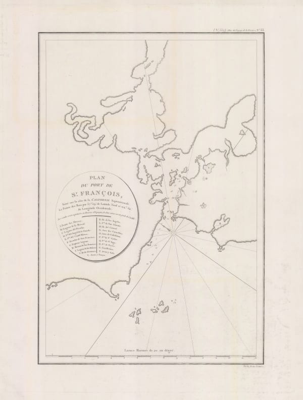
 Jean Francois de La Perouse, Earliest commercially available map of San Francisco Bay, 1797£ 1,650.00
 -
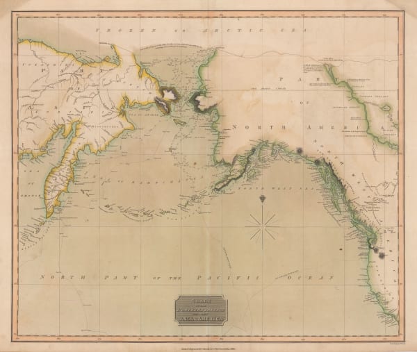
Count Jean-Francois de la Perouse, Chart of the North Pacific, 1797£ 750.00
-
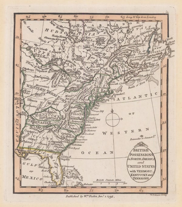
William Faden, East coast of the USA and Canada, 1798£ 385.00
-
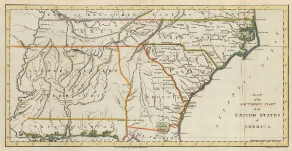
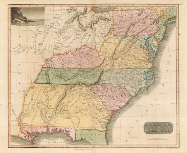
John Russell, Map of the Southern Part of the United States of America, 1798£ 745.00
-
John Stockdale, Eastern United States, 1798£ 845.00
-
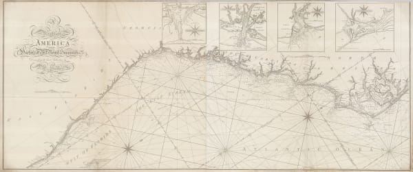
William Heather, Chart of the East coast from the Outer Banks of North Carolina to Fort Lauderdale, 1799£ 4,250.00
-
Tardieu, North and South Carolina and Virginia, 1800£ 825.00
-
Daniel Friedrich Sotzmann, North West Pacific coast of America, 1800£ 795.00
-
Carl Jaettnig, Eastern United States, 1800£ 545.00
-
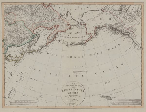
Christian Gottlieb Reichard, Chart of the North Pacific Ocean, 1804£ 785.00
-
Thomas and Andrews, Connecticut, 1805£ 265.00
-
Thomas and Andrews, Georgia, 1805£ 345.00
-
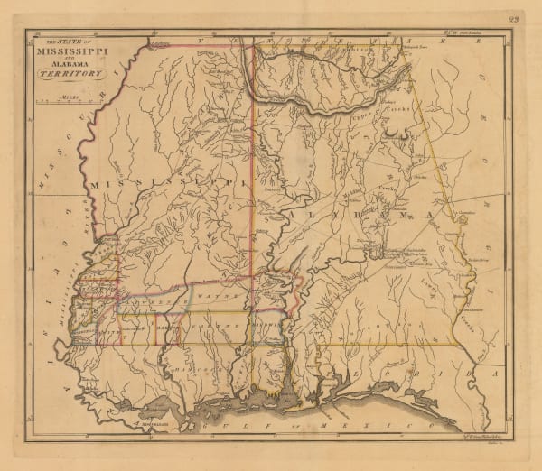
Thomas and Andrews, Mississippi Territory, 1805£ 345.00
-
Morse and Andrews, New Hampshire, 1805£ 295.00
-
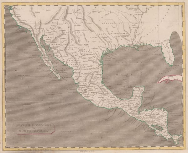
Thomas and Andrews, Mexico and Southern United States, 1805£ 225.00
-
Samuel Lewis, The State of New Hampshire, 1805£ 325.00
-
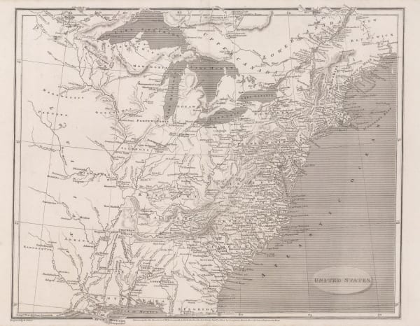
Aaron Arrowsmith, United States, 1805£ 375.00
-
Morse and Andrews, Vermont, 1805£ 245.00
-
Matthew Carey, Maryland, 1805£ 445.00
-
Matthew Carey, Connecticut from the Best Authorities, 1805 c.£ 1,350.00
-
John Russell, Eastern United States, 1805 c.£ 125.00
-
John Cary, North-eastern United States, 1806£ 1,100.00
-
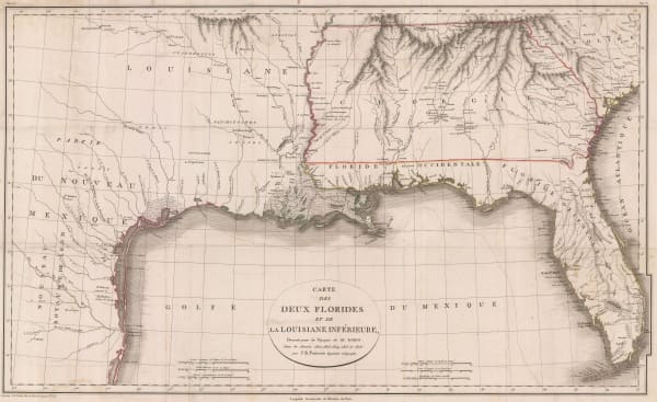
Jean-Baptiste Poirson, Texas, Louisiana, Alabama, Mississippi, Florida and Georgia, 1807£ 2,500.00
-
William Faden, James Cook's Voyage to Alaska & the Bering Strait, 1808£ 2,850.00
-
Spanish Admiralty, St. Augustine, 1809£ 975.00
-
Spanish Admiralty, Rare Spanish Admiralty chart of the mouth of the St. Johns River, 1809£ 450.00
-
John Pinkerton, South-eastern United States, 1809£ 1,350.00
-
Neele, Map of Canada, 1809£ 485.00
-
John Pinkerton, North-eastern United States, 1810£ 1,350.00
-
George Cooke, A Map of the United States of America, 1810 c.£ 115.00
-
Tardieu, North-eastern United States, 1810 c.£ 495.00
-
John Luffman, New York, 1810 c.£ 545.00
-
John Pinkerton, Southwestern Unites States, 1811£ 3,500.00
-
-
Matthew Carey, Connecticut, 1813£ 285.00
-
Matthew Carey, Delaware, 1813£ 245.00
-
Matthew Carey, Louisiana, 1813£ 245.00
-
Matthew Carey, Vermont, 1813£ 325.00
-
John Thomson, Texas, New Mexico, Arizona and Mexico, 1814£ 2,250.00
-
John Thomson, Eastern United States and the St Lawrence river, 1814 c.£ 1,450.00
-
Edmund Blunt, The Bay of Chesapeake from its Entrance to Baltimore, 1815£ 495.00
-
John Wilkes, North America, 1815 c£ 445.00
-
John Thomson, Chart of the North Pacific and Behring Straits, 1816£ 525.00
-
Edward Baines, United States and Canada during the War of 1812, 1816£ 295.00
-
John Thomson, Eastern United States, 1817£ 1,250.00
-
John Thomson, Northern Provinces of the United States, 1817£ 1,350.00
-
J. Freeman & Samuel Dana, A Geological Map of Boston and its Vicinity, 1818£ 1,450.00
-
Matthew Carey, Delaware from the best Authorities, 1818£ 1,150.00
-
Matthew Carey, Louisiana, 1818£ 1,450.00
-
William James, Map of Maj. Gen. Ross's route, with the British Column, from Benedict, on the Patuxent River, to the City of Washington, August 1814, 1818£ 885.00
-
Matthew Carey, Map of the United States of America, 1818£ 1,650.00
-
Matthew Carey, The State of Georgia, 1818£ 1,650.00
-
Matthew Carey, The State of Massachusetts, 1818£ 1,850.00
-
Matthew Carey, The State of Mississippi and Alabama Territory, 1818£ 1,250.00
-
Matthew Carey, The State of New Jersey Compiled from the most Authentic Information, 1818£ 1,550.00
-
Matthew Carey, The State of Tennessee, 1818£ 1,450.00
-
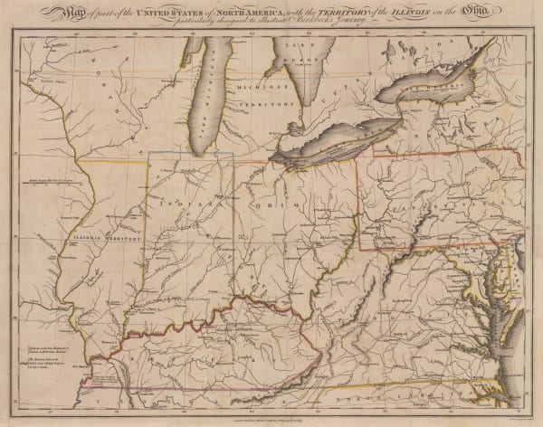
Morris Birkbeck, Early map of Ohio, Indiana and the Territory of Illinois, 1818£ 1,250.00
-
William Faden, Southwest USA and Mexico, 1819£ 245.00
-
Pierre Tardieu, Eastern United States and West Indies., 1820 c.£ 175.00
-
Daniel & William Lizars, Plan of the City of Washington and Territory of Columbia, 1820 c.£ 1,850.00
-
Daniel & William Lizars, United States, 1820 c.£ 365.00
-
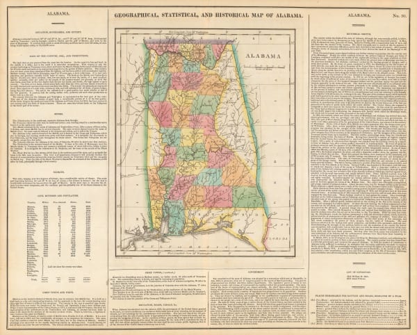
Carey & Lea, Geographical, Statistical and Historical map of Alabama, 1822£ 1,250.00
-
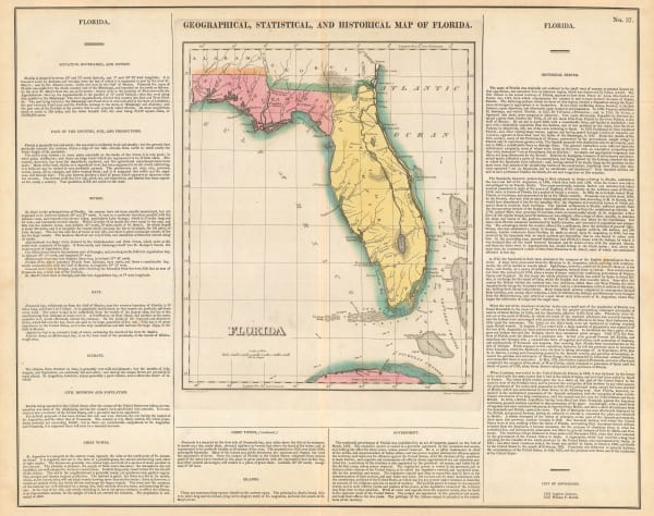
Carey & Lea, Geographical, Statistical and Historical map of Florida, 1822£ 2,450.00
-
Carey & Lea, Geographical, Statistical and Historical map of Georgia, 1822£ 1,950.00
-
Carey & Lea, Geographical, Statistical and Historical map of Indiana, 1822£ 1,150.00
-
Carey & Lea, Geographical, Statistical and Historical map of Louisiana, 1822£ 1,750.00
-
Carey & Lea, Geographical, Statistical and Historical map of Maine, 1822£ 1,750.00
-
Carey & Lea, Geographical, Statistical and Historical map of Massachusetts, 1822£ 1,950.00
-
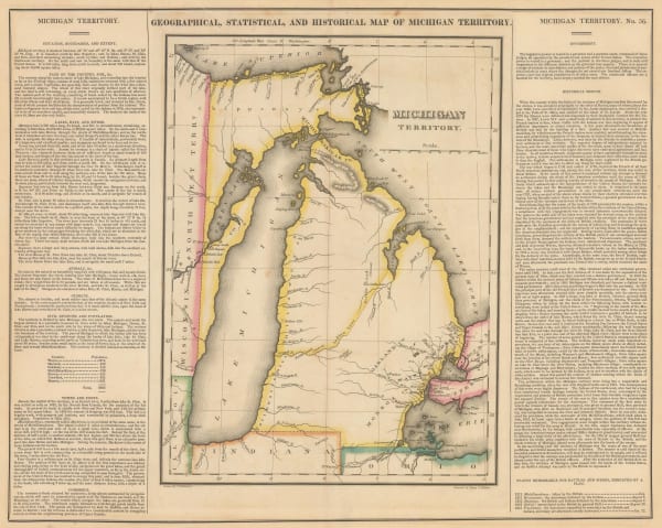
Carey & Lea, Geographical, Statistical and Historical Map of Michigan Territory, 1822£ 1,850.00
-
Carey & Lea, Geographical, Statistical and Historical map of New Jersey, 1822£ 1,650.00
-
Carey & Lea, Geographical, Statistical and Historical map of New York, 1822£ 1,550.00
-
Carey & Lea, Geographical, Statistical and Historical map of North Carolina, 1822£ 2,250.00
-
Carey & Lea, Geographical, Statistical and Historical Map of Pennsylvania, 1822£ 1,550.00
-
Carey & Lea, Geographical, Statistical and Historical map of Tennessee, 1822£ 1,550.00
-
Carey & Lea, Geographical, Statistical and Historical map of Vermont, 1822£ 985.00
-
-
Carey & Lea, Geographical, Statistical and Historical Map of Mississippi, 1823£ 725.00
-
Carey & Lea, Geographical, Statistical and Historical Map of Rhode Island, 1823£ 1,750.00
-
Carey & Lea, Geographical, Statistical, and Historical Map of Connecticut, 1823£ 1,650.00
-
Carey & Lea, Geographical, Statistical, and Historical Map of Delaware, 1823£ 700.00


Page
4
of 15