-
 Carey & Lea, Geographical, Statistical, and Historical Map of Kentucky, 1823£ 1,250.00
 -
Carey & Lea, Geographical, Statistical, and Historical Map of Maryland, 1823£ 1,850.00
-
Carey & Lea, Geographical, Statistical, and Historical Map of Ohio, 1823£ 875.00
-
Carey & Lea, Geographical, Statistical, and Historical Map of the District of Columbia, 1823£ 1,750.00
-
John Cary, South-eastern United States, 1825£ 1,675.00
-
John Cary, Eastern United States, 1825£ 1,475.00
-
Jean Buchon, Geographical, Statistical and Historical map of Indiana, 1825£ 125.00
-
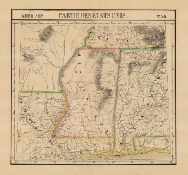
Jean Buchon, Geographical, Statistical and Historical map of Mississippi, 1825£ 175.00
-
Geographisches Institut Weimar, Geographical, Statistical, and Historical Map of Connecticut, 1825£ 200.00
-
Philippe Vandermaelen, California coast, 1825£ 1,550.00
-
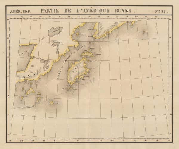
Philippe Vandermaelen, Kodiak Island and the coast of Alaska, 1825£ 100.00
-
Philippe Vandermaelen, Alaska Peninsula, Unimak Isle, St. George and St. Paul, 1825£ 100.00
-
Geographisches Institut Weimar, Geographical, Statistical, and Historical Map of Maryland, 1826£ 385.00
-
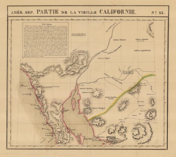
Philippe Vandermaelen, Southern California, Baja, Sonora & Arizona, 1827£ 750.00
-
Philippe Vandermaelen, Mississippi and Alabama, 1827£ 650.00
-
Philippe Vandermaelen, Coast of Oregon and Washington State, 1827£ 2,450.00
-
Philippe Vandermaelen, Oregon Territory or parts of Idaho, Montana and Wyoming, 1827£ 725.00
-
Philippe Vandermaelen, Minnesota, 1827£ 625.00
-
Philippe Vandermaelen, Cape Cod to Chesapeake Bay, 1827£ 350.00
-
Philippe Vandermaelen, Northeastern United States, 1827£ 450.00
-
Philippe Vandermaelen, Indiana, Kentucky, Ohio and West Virginia, 1827£ 550.00
-
Philippe Vandermaelen, Missouri and Illinois, 1827£ 895.00
-
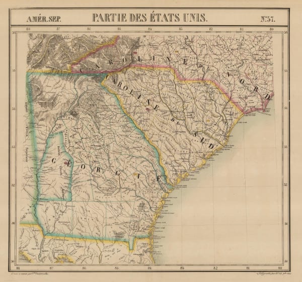
Philippe Vandermaelen, North and South Caroline and Georgia, 1827£ 725.00
-
Philippe Vandermaelen, Early survey south of Utah Lake, 1827£ 450.00
-
Philippe Vandermaelen, Coast of Texas from Rio del Norte to Sabine River, 1827£ 1,450.00
-
Philippe Vandermaelen, Montana and the Dakotas, 1827£ 600.00
-
I.T. Hinton, Map of the States of Kentucky and Tennessee, 1831£ 220.00
-
I.T. Hinton, Map of Maine, New Hampshire and Vermont, 1832£ 345.00
-
I.T. Hinton, Map of the State of Missouri, 1832£ 245.00
-
Map of the States of Indiana and Ohio with Part of Michigan Territory, 1832I.T. HintonSeries: LondonI.T. Hinton, Map of the States of Indiana and Ohio with Part of Michigan Territory, 1832£ 295.00
-
I.T. Hinton, Map of the States of Pennsylvania and New Jersey, 1832£ 240.00
-
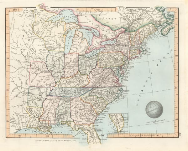
I.T. Hinton, Map of the United States of America and Nova Scotia, 1832£ 285.00
-
Society for the Diffusion of Useful Knowledge (SDUK), North America Sheet IV - Lake Superior, 1832£ 85.00
-
Society for the Diffusion of Useful Knowledge (SDUK), North America - Sheet IX, Parts of Missouri, Illinois and Indiana, 1833£ 85.00
-
Society for the Diffusion of Useful Knowledge (SDUK), Ohio and Kentucky, 1833£ 92.00
-
Society for the Diffusion of Useful Knowledge (SDUK), North America Sheet X, 1833£ 76.00
-
Society for the Diffusion of Useful Knowledge (SDUK), Eastern United States, 1834£ 225.00
-
Charles Smith, United States, 1834£ 295.00
-
Samuel Augustus Mitchell, United States, 1835£ 1,850.00
-
Henry Teesdale, Southwestern USA and Mexico, 1835 c.£ 545.00
-
Adrien Brue, United States showing westward expansion, 1836£ 895.00
-
Enoch Steen, Dodge's Expedition through Kansas & Colorado, 1836£ 950.00
-
Washington Hood, Map - Illustrating the plan of the defences of the Western & North-Western Frontier, 1837£ 625.00
-
Spanish Admiralty, Chart of Florida, Bahamas and Cuba , 1838£ 4,850.00
-
Washington Hood, Map of the United States Territory of Oregon West of the Rocky Mountains, 1838£ 2,450.00
-
Revd. Samuel Parker, Map of Oregon Territory, 1838£ 2,850.00
-
Samuel Augustus Mitchell, Southeastern United States, 1839£ 145.00
-
Samuel Augustus Mitchell, Midwestern United States, 1839£ 185.00
-
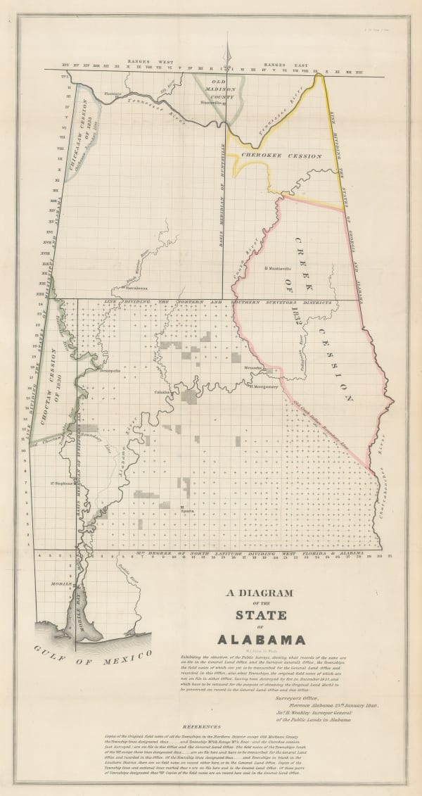
James Harvey Weakley, A Diagram of the State of Alabama, 1840£ 385.00
-
Carl Flemming, United States of North America, 1840 (c.)£ 885.00
-
Henry Teesdale, Mexico and the South/Southwestern United States, 1841£ 945.00
-
James Wyld, The United States of North America with the British Territories, 1841£ 1,850.00
-
-
Society for the Diffusion of Useful Knowledge (SDUK), Boston, 1842£ 695.00
-
Society for the Diffusion of Useful Knowledge (SDUK), Southwestern United States and Northern Mexico, 1842£ 625.00
-
John Arrowsmith, Victorian map of the Eastern United States, 1842£ 595.00
-
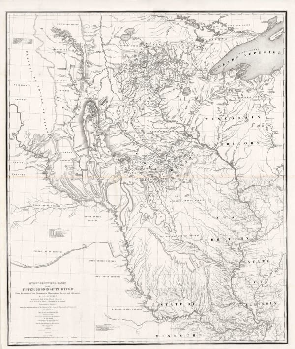
Joseph Nicolas Nicollet, Hydrographical Basin of the Upper Mississippi River, 1843£ 3,450.00
-
Thomas Tegg, United States, 1843£ 55.00
-
Samuel Augustus Mitchell, National Map of the American Republic, 1843£ 1,450.00
-
Samuel Augustus Mitchell, US Cities and Statistics, 1843£ 1,150.00
-
Joseph Meyer, German map of Arkansas, 1844£ 245.00
-
Joseph Meyer, State of New York, 1844£ 385.00
-
Joseph Meyer, New York City, 1844£ 845.00
-
-
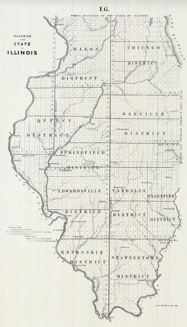
General Land Office, Diagram of the State of Illinois, 1845£ 120.00
-
John C. Fremont, Map of an Exploring Expedition to the Rocky Mountains in the Year 1842 and to Oregon & North California in the Years 1845-44, 1845£ 3,950.00
-
General Land Office, Map of the State of Florida, 1845£ 725.00
-
Joseph Meyer, Kentucky, 1845£ 275.00
-
Joseph Meyer, Alabama, 1845£ 265.00
-
Joseph Meyer, Louisiana and New Orleans, 1845£ 325.00
-
Joseph Meyer, Maine, 1845£ 255.00
-
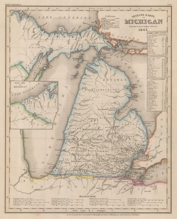
Joseph Meyer, Michigan, 1845£ 345.00
-
Joseph Meyer, Missouri, 1845£ 160.00
-
Joseph Meyer, German map of Ohio, 1845£ 245.00
-
Joseph Meyer, Pennsylvania, 1845£ 275.00
-
George Frederick Cruchley, North America, 1845£ 120.00
-
Joseph Meyer, Street plan of Washington D. C., 1845£ 745.00
-
General Land Office, Sketch of the Public Surveys of Michigan, 1845£ 155.00
-
George Frederick Cruchley, United States, 1845£ 140.00
-
Joseph Meyer, Illinois, 1845£ 325.00


Page
5
of 15