Utah
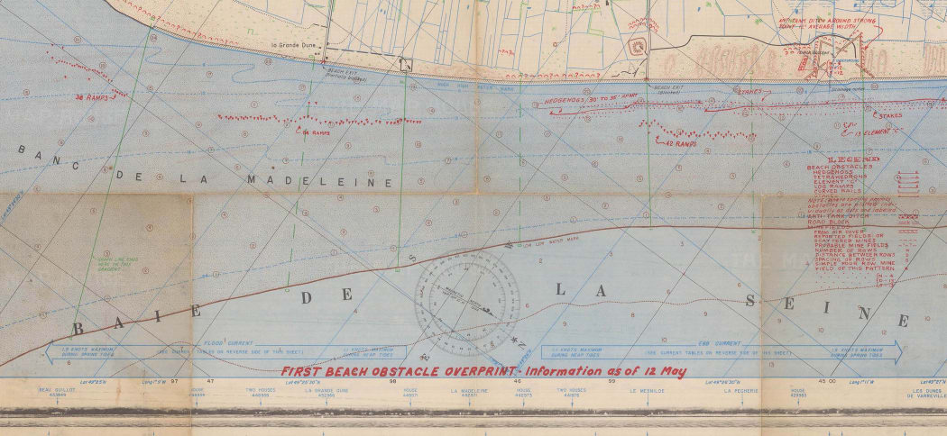
An extraordinarily rare surviving ultra-top secret operational map for landing craft commanders on Utah Beach used during the D-Day landings.
“Top Secret – Bigot” was the Allies’ highest level of secrecy during WWII. The Bigot List was a list of named individuals who were the only persons allowed to know both the proposed sites and dates of the D-Landings. Because of the danger of capture by the Germans the only person on the Bigot List allowed to go outside mainland Britain is believed to be Winston Churchill and as a safeguard his personal bodyguard was instructed to shoot the Prime Minister if there was any danger of him falling into enemy hands.
First prepared on 21st April 1944, the map has been over-printed in red with the latest information about beach defences dated 12th May.
On the reverse of the chart are detailed information and diagrams relating to currents, tides, sunlight and moonlight from the 25th May to the 21st June.
Gold and Juno Beaches
An extremely detailed map of the German defences both on the shoreline and inland of Gold and Juno Beaches. This map was first printed in April 1944 and then further updated, preparatory to the landings, in May.
On a scale of 2.53 inches to the mile, this map lists in incredible detail all the German defences; both confirmed (blue) and unconfirmed (purple). Individual gun positions, from heavy artillery right down to single machine guns are indicated along with static defences both abandoned and under construction.
On the reverse of the map is the key to the symbols.
Sword
This map, which continues on from the previous map of Gold and Juno Beaches, details the extensive German defences around Roches de Lion and St. Aubin sur Mer. All the houses along the seafront are marked as having been fortified and loopholed for infantry and machine guns. Together with extensive mine fields and artillery, there is also note that 22m. AA guns (Flak 30 or 38’s, a very effective anti-personnel weapon) are sited ever 100 yards on the roofs.
Gold
This exceptionally rare chart vividly illustrates the planning behind Operation Neptune, the largest seaborne invasion in history. It shows the proposed anchorages for the vast fleets of support vessels necessary to supply an entire army by sea.
Of particular interest is the planned siting of “Mulberry B”, one of the most extraordinary engineering feats of the entire war. The Mulberry’s (A and B) were two vast pre-built concrete harbours with a combined weight of 1.5 million tons designed to be floated across the Channel and sunk into position off Omaha (A) and Gold Beaches (B). This chart was produced in February 1944, shortly after the undercover surveys of the Normandy had been completed in January.
On 19th June Mulberry A was destroyed in a storm but B survived and in the ten months after D-Day it was used to land over 2.5 million men, 500,000 vehicles, and four million tons of supplies and proved essential in ensuring the success of the invasion.
Pegasus Bridge
The capture of “Pegasus Bridge” by glider infantry of the British 6th Airborne Division at 16 minutes past midnight on 6th June was the first Allied action on D-Day.
The capture of the two bridges over the Caen Canal, “Pegasus” and nearby “Horsa” was essential to stop the very real danger of German armoured forces counter-attacking the vulnerable Allies while still establishing the beachheads.
In one of the outstanding feats of flying of the war, five of the six gliders that set off from England, landed within about 100 yards of their targets and within ten minutes had captured both bridges. Lieutenant Den Brotheridge, shot by a sentry, was the first Allied soldier killed by enemy action on D-day.
This map has its contours shaded in with coloured pencil, no doubt to make it easier to interpret in the field.
The Defences of Caen

This map shows the strength and depth of the defences surrounding the important German stronghold of Caen. The inability to disembark troops fast enough onto the narrow landing beaches and, arguably, unnecessary caution on the part of the British commanders, Caen had avoided being captured in the very early stages of the invasion. The Germans were able to rush in reinforcements and it proved a major hindrance to the Allied advance into Normandy. This map shows the situation on 2nd July on the eve of Operation Charnwood, which would result in the capture of the Caen on 9th July. The sheer density of the German defences, both confirmed (in blue) or supposed (in red), are daunting in the extreme. It was because of this that the Allies controversially decided to launch a devastating bomber raid on the city prior to the ground assault. On 7th July 467 bombers dropped 2,000 tons of bombs on the German defences and in the process virtually destroying the city. This was followed by an artillery bombardment by over 600 field guns, with support from the battleship, Rodney and other naval vessels. On 9th July the Allied forces finally entered the rubble of what was once the ancient city of Caen.

About the author
The Map House


