-
 Robert de Vaugondy, French Louisiana and the course of the Mississippi River, 1749£ 295.00
 -
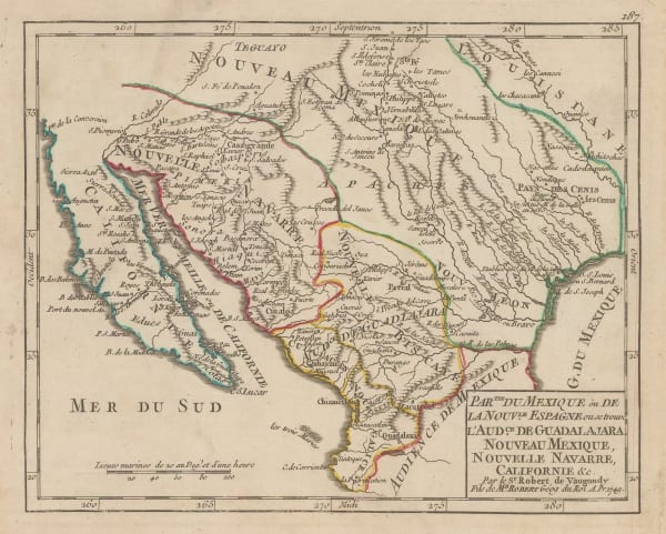
Robert de Vaugondy, Southwestern US and northern Mexico, 1749£ 465.00
-
Jacques-Nicolas Bellin, Early map of Louisiana and the Mississippi Valley, 1750£ 445.00
-
Jacques-Nicolas Bellin, Russian Discoveries in Siberia, Alaska & the Bering Strait, 1750 c.£ 725.00
-
Tobias Conrad Lotter, New England and New York, 1750 c.£ 3,850.00
-
Jacques-Nicolas Bellin, Chesapeake Bay, Maryland, Virginia, New Jersey, and Pennsylvania, 1750 c.£ 745.00
-
-
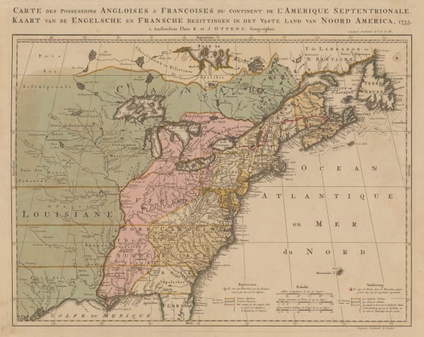
Josua & Reinier Ottens, French and Indian War, 1755£ 4,850.00
-
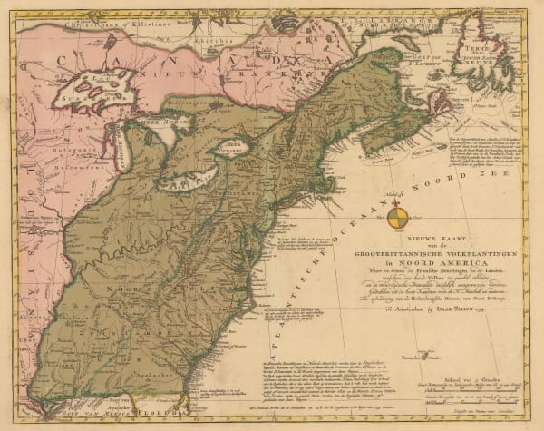
Isaac Tirion, East coast showing British claims, 1755£ 1,125.00
-
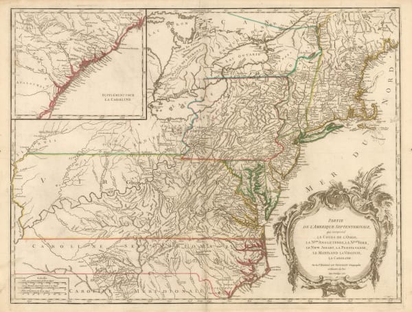
Robert de Vaugondy, Ohio River and Northeast Colonies, 1755£ 1,650.00
-
Homann Heirs, Important German rendition of Bellin's seminal map of the Great Lakes, 1755£ 3,650.00
-
Robert de Vaugondy, Virginia, Maryland & Delaware, 1755£ 4,950.00
-
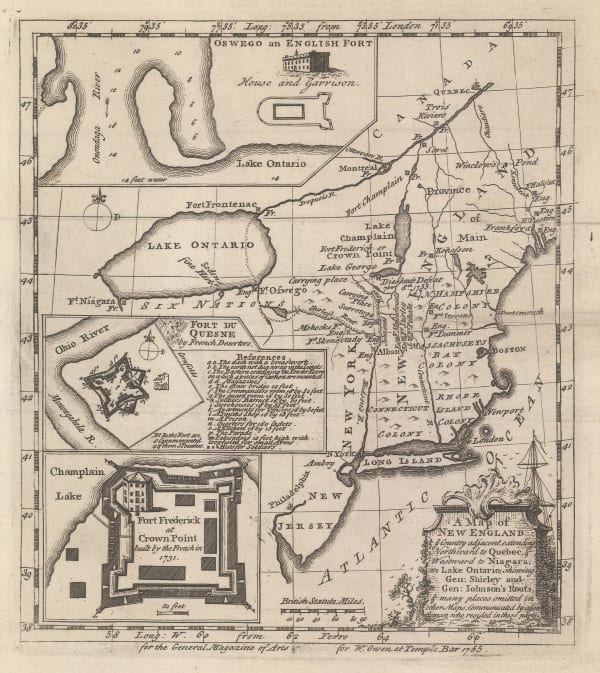
William Owen, French & Indian War Map of New England, 1755£ 950.00
-
Thomas Bowen, British and French Settlements in America, 1755£ 4,500.00
-
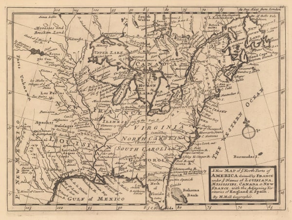
Herman Moll, United States and Canada, 1755 c.£ 1,250.00
-
Herman Moll, A Plan of Port Royal Harbour in Carolina, 1755 c.£ 395.00
-
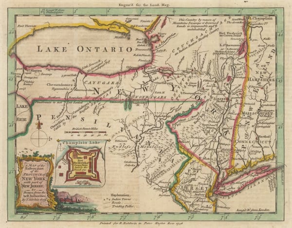
Herman Moll, New England, New York, New Jersey and Pennsilvania, 1755 c.£ 1,750.00
-
-
London Magazine, New York State and northern New Jersey, 1756£ 525.00
-
London Magazine, A Map of the Province of Pennsylvania, 1756£ 495.00
-
London Magazine, A Map of Maryland with the Delaware Counties and the Southern Part of New Jersey, 1757£ 625.00
-
Jacques-Nicolas Bellin, Georgia and North and South Carolina, 1757£ 675.00
-
Jacques-Nicolas Bellin, New England, 1757£ 575.00
-
Covens (Jean) & Mortier (Cornelius), L'Amerique Septenrionale, 1757£ 4,200.00
-
-
Jacques-Nicolas Bellin, Boston, 1757£ 625.00
-
London Magazine, Connecticut and Rhode Island, 1758£ 685.00
-
London Magazine, A New Map of the Cherokee Nation, 1760£ 2,250.00
-
Jacques-Nicolas Bellin, Coastal chart from Cape Fear to St. Augustine, 1760 c.£ 345.00
-
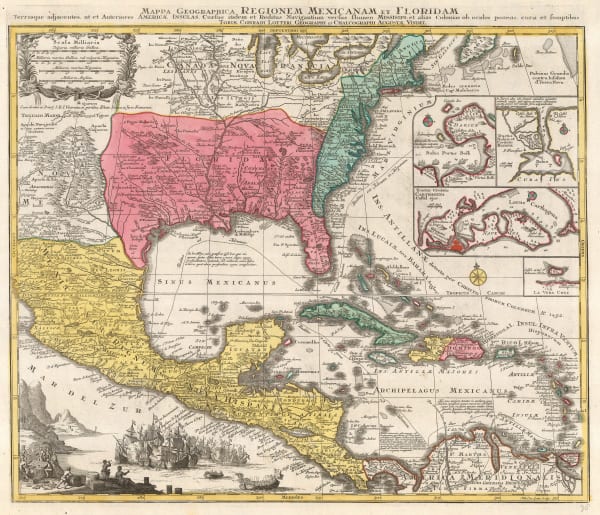
Tobias Conrad Lotter, Southern USA, Mexico, Central America & the Caribbean, 1760 c.£ 3,450.00
-
London Magazine, A New Map of Virginia, 1761£ 595.00
-
John Gibson, A Plan of the City of Philadelphia with the Country Adjacent., 1761£ 245.00
-
-
Andrea Scacciati, Carta rappresentante i cinque Laghi del Canada, 1763£ 675.00
-
Gazettiere Americano, St. Augustine, 1763£ 785.00
-
Veremondo Rossi, Caribbean, Central American and Southern United States, 1763£ 545.00
-
Thomas Kitchin, Colonial America, 1763£ 1,350.00
-
Jacques-Nicolas Bellin, North-eastern United States, 1764£ 1,500.00
-
Jacques-Nicolas Bellin, Florida and Louisiana coast, 1764£ 4,950.00
-
Jacques-Nicolas Bellin, French Louisiana, 1764£ 395.00
-
Jacques-Nicolas Bellin, Plan de Philadelphia et Environs, 1764£ 695.00
-
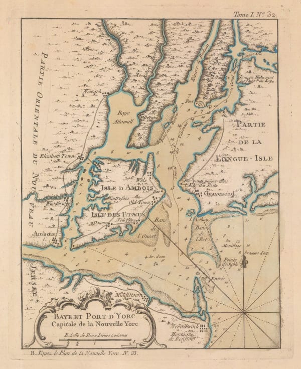
Jacques-Nicolas Bellin, New York Bay, 1764£ 975.00
-
Jacques-Nicolas Bellin, Charleston, 1764£ 1,250.00
-
Jacques-Nicolas Bellin, The Mississippi and Red Rivers, 1764£ 650.00
-
Jacques-Nicolas Bellin, The Gulf coast of Florida and Alabama, 1764£ 450.00
-
Jacques-Nicolas Bellin, St Lawrence River and Lake Champlain , 1764£ 445.00
-
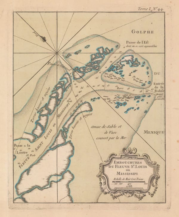
Jacques-Nicolas Bellin, Mouth of the Mississippi River, 1764£ 495.00
-
Jacques-Nicolas Bellin, Boston Bay, 1764£ 675.00
-
Jacques-Nicolas Bellin, Boston, 1764£ 545.00
-
Jacques-Nicolas Bellin, St Augustine Port, Florida, 1764£ 395.00
-
Jacques-Nicolas Bellin, Pensacola, Florida, 1764£ 495.00
-
Jacques-Nicolas Bellin, The Earliest Obtainable Map of New York City, 1764£ 3,750.00
-
London Magazine, A New Map of North & South Carolina, & Georgia, 1765£ 595.00
-
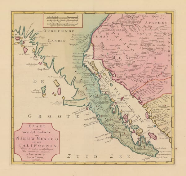
Isaac Tirion, Lower California and the Baja Peninsula, 1765£ 1,450.00
-
London Magazine, Louisiana, as formerly claimed by France, 1765£ 375.00
-
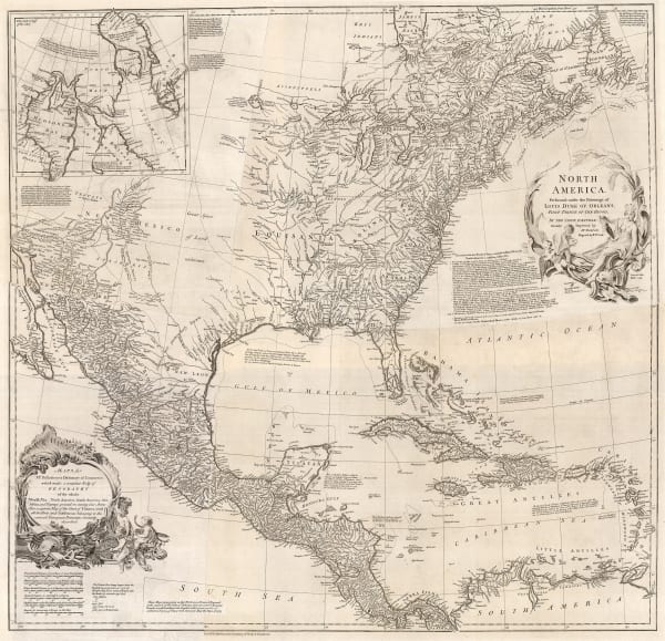
Malachy Postlethwayt, North America, 1766£ 3,850.00
-
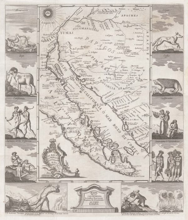
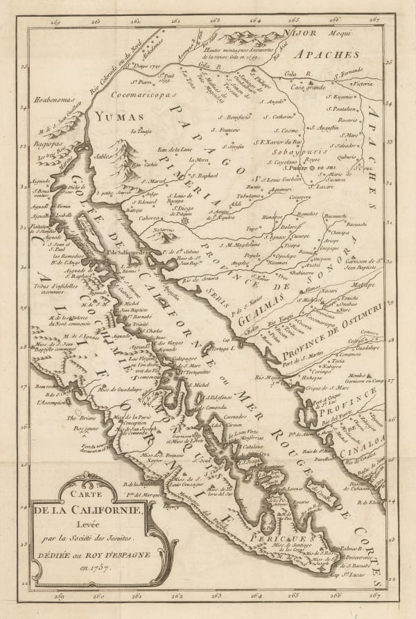
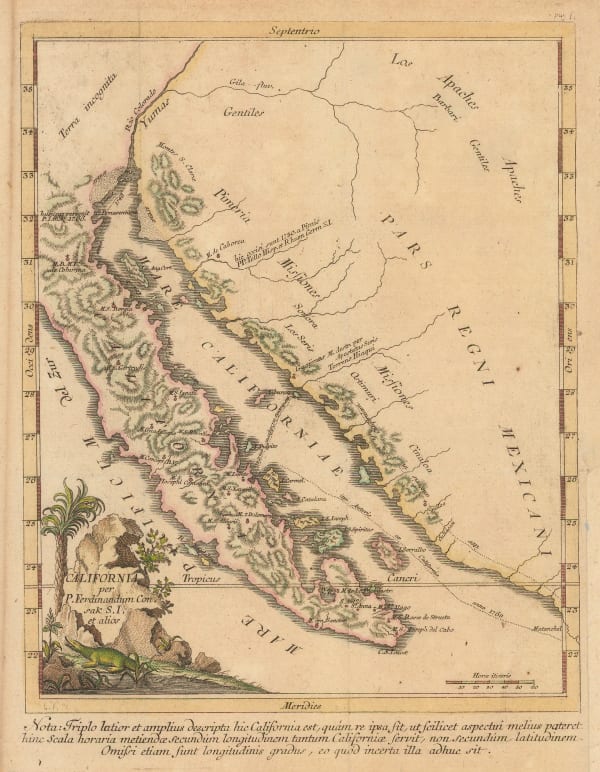
Miguel Venegas, French edition of the influential Jesuit map of California, 1767£ 1,575.00
-
Johann Heinrich Heidegger, Northwestern USA, Eastern Russia and the North Pacific, 1770 c.£ 795.00
-
-
Gentleman's Magazine, Coastal chart from the Mississippi to Pensacola Bay, 1772£ 495.00
-
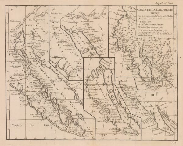
Robert de Vaugondy, Cartographic history of California, 1772£ 1,150.00
-
Robert de Vaugondy, West coast of North America, 1772£ 695.00
-
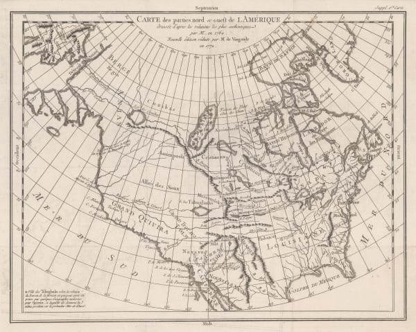
Robert de Vaugondy, Carte des Parties Nord et Ouest de l'Amerique, 1772£ 695.00
-
Rigobert Bonne, Eastern North America, 1772£ 1,250.00
-
Johann Jakob Baegert, California, 1773£ 1,150.00
-
London Magazine, A chart of the Coast of New England from Beverly to Scituate Harbour, 1774£ 1,650.00
-
-
-
-
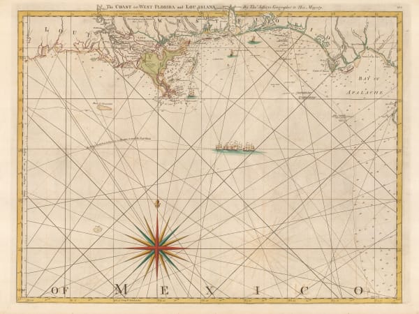
Thomas Jefferys, The Coast of West Florida and Louisiana, 1775£ 1,250.00
-
Robert Sayer, Russian Discoveries in Siberia, Alaska & the Bering Strait, 1775£ 1,325.00
-
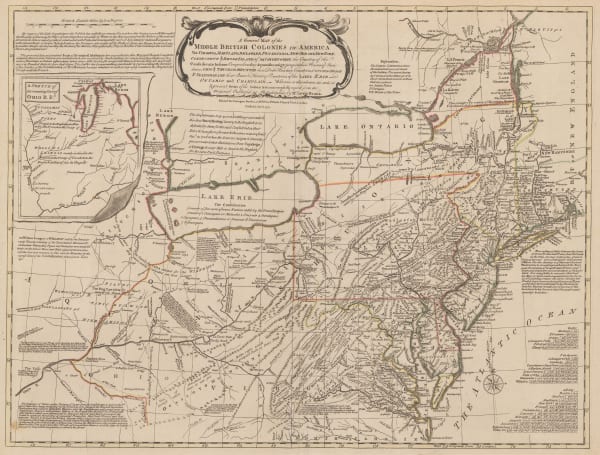
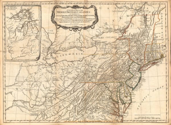
Sayer & Bennett, Revolutionary War map of the 'Middle British Colonies', 1776£ 4,450.00
-
Francois Santini, Carte Generale du Canada, de la Louisiane, de la Floride, de la Caroline, de la Virginie, de la Nouvelle Angleterre etc., 1776£ 700.00
-
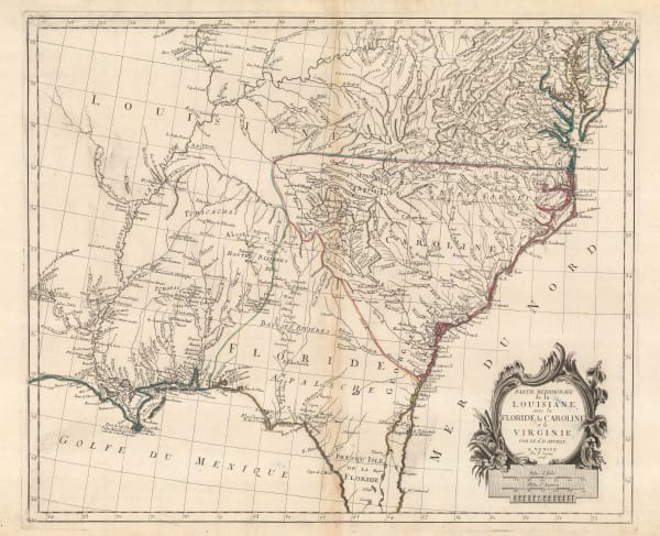
Francois Santini, Louisiana, Florida and the Carolinas, 1776£ 985.00
-
Sayer & Bennett, Amelia Island, 1776£ 1,800.00
-
Antonio Zatta, Alaska, the Pacific Northwest, and the Bering Strait, 1776£ 1,250.00
-
Robert de Vaugondy, Virginia, Maryland & Delaware, 1776 c£ 4,500.00
-
Louis Joseph Mondhare, Scarce Revolutionary War map, 1777£ 3,250.00
-
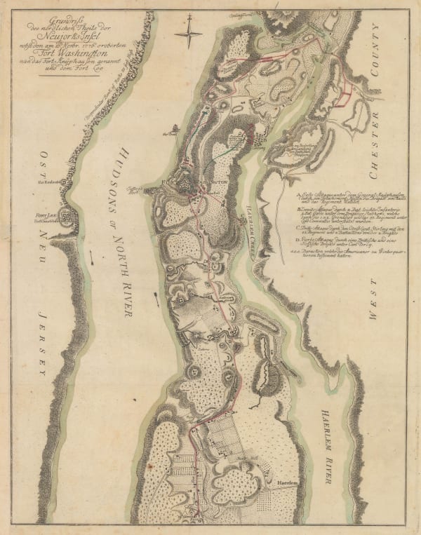
Gabriel Nikolaus Raspe, Revolutionary War map of New York island north of Harlem, 1777£ 2,850.00
-
Dr. William Robertson, Southwestern United States and Mexico, 1777£ 1,150.00


Page
2
of 15