-
 Letts & Son, Delhi, Agra & Jaipur, 1889£ 85.00
 -
Edward Stanford, The Rivers of India, 1889£ 595.00
-
Arbuckle Brothers Company, Afghanistan, 1889£ 125.00
-
Arbuckle Brothers Company, India, 1889£ 165.00
-
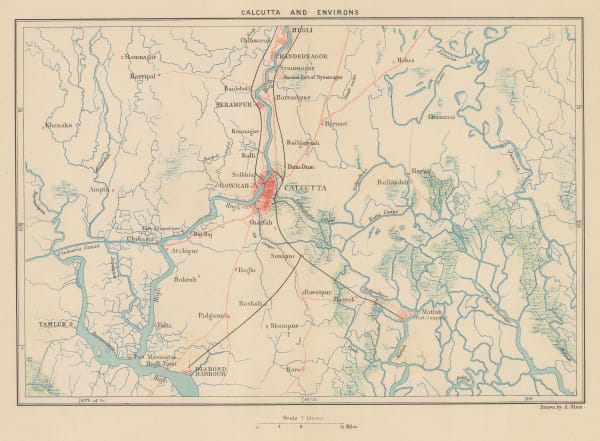
George Virtue, Kolkata (Calcutta) and environs, 1890 c.£ 45.00
-
G. & J. Bartholomew, Southern India, 1890 c.£ 38.00
-
G. & J. Bartholomew, Mumbai (Bombay), 1890 c.£ 42.00
-
G. & J. Bartholomew, Mumbai (Bombay), 1890 c.£ 36.00
-
G. & J. Bartholomew, Madras, Hydrabad, Mysore, Coorg and Ceylon, 1891£ 58.00
-
Scottish Geographical Society (SGS), General Map of Pamir and Surrounding Countries, 1892£ 325.00
-
Letts & Son, India, 1892£ 82.00
-
Letts & Son, Eastern Gujarat , 1892£ 68.00
-
Letts & Son, Telangana and Odisha states, 1892£ 72.00
-
Letts & Son, City plan of Kolkata (Calcutta), 1892£ 195.00
-
G. & J. Bartholomew, Prayagraj (Allahabad), 1893£ 48.00
-
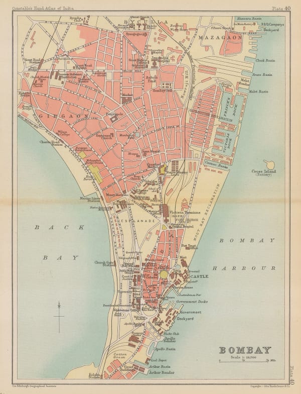
John Bartholomew, Plan of central Mumbai (Bombay), 1893£ 84.00
-
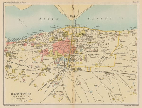
John Bartholomew, Kanpur (Cawnpur) and Environs, 1893£ 52.00
-
George Philip, India (South Sheet), 1893£ 65.00
-
G. & J. Bartholomew, India Prevailing Races, 1893£ 68.00
-
G. & J. Bartholomew, Kashmir, the Himalayas, and Western China, 1893£ 44.00
-
G. & J. Bartholomew, Lucknow and Environs, 1893£ 52.00
-
G. & J. Bartholomew, Matheran, 1893£ 46.00
-
G. & J. Bartholomew, Uttar Pradesh, Bihar and Jharkhand, 1893£ 38.00
-
G. & J. Bartholomew, Section X. Bombay, Berar, 1893£ 48.00
-
G. & J. Bartholomew, Shimla and environs, 1893£ 42.00
-
G. & J. Bartholomew, Kolkata (Calcutta), 1893£ 42.00
-
G. & J. Bartholomew, Odisha and Chhattisgarh, 1893£ 38.00
-
G. & J. Bartholomew, Maharasthtra, Goa, Telagana, Karnataka and Andhra Pradesh, 1893£ 38.00
-
G. & J. Bartholomew, India: Land Surface Elevation, 1893£ 64.00
-
W. & A.K. Johnston, Rajastan, Madhya Pradesh, Uttar Pradesh and Jharkhand, 1894£ 92.00
-
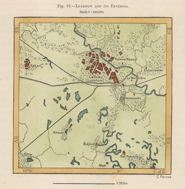
Jean Jacques Élisée Reclus, Lucknow and its Environs, 1894£ 32.00
-
Jean Jacques Élisée Reclus, Chennai (Madras), 1894£ 32.00
-
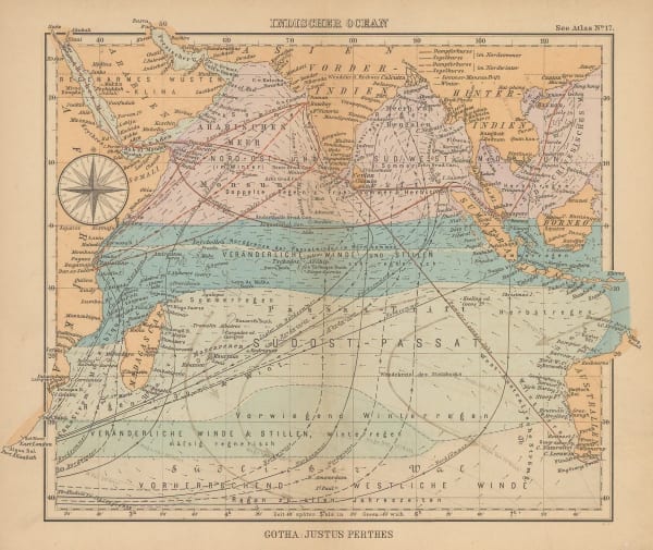
Justus Perthes, Indian Ocean, 1895£ 38.00
-
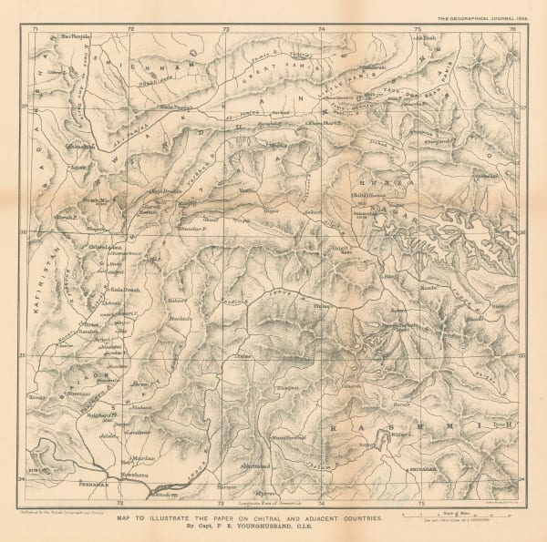
Royal Geographical Society (RGS), Map to Illustrate the Paper on Chitral and Adjacent Countries, 1895£ 425.00
-
Edward Stanford, Ceylon (Sri Lanka), 1896£ 145.00
-
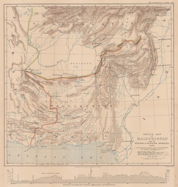
Royal Geographical Society (RGS), Sketch map of Beluchistan and its Afghan and Persian Borders, 1897£ 175.00
-
Survey of India, North Western Provinces and Oudh Survey, 1898£ 495.00
-
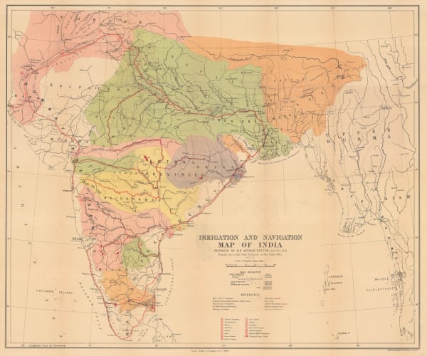
Arthur Cotton, Irrigation and Navigation Map of India, 1900£ 695.00
-
Royal Geographical Society (RGS), Part of Tibet and Sin-Chiang, 1900£ 545.00
-
George Philip, Map of the Eastern Indian Railway, 1900 c.£ 385.00
-
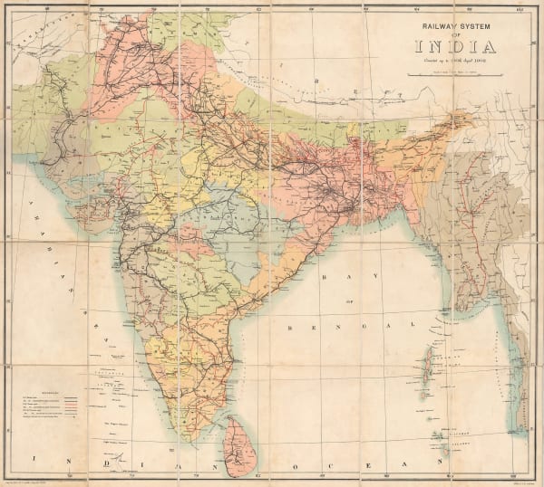
Survey of India, Railway System of India, 1902£ 585.00
-
Royal Geographical Society (RGS), Tibet, Map showing Explorations by Major C. H. D. Ryder RE DSO and Captains H. Wood RE & H. W. Cowie RE of the Tibet Frontier Commission 1904, 1905£ 375.00
-
The Territories of the Maharaja of Jummoo and Kashmir, 1905 (c.)Thacker, Spink & Co.Series: CalcuttaThacker, Spink & Co., The Territories of the Maharaja of Jummoo and Kashmir, 1905 (c.)£ 375.00
-
Royal Geographical Society (RGS), Indian Ocean, 1906£ 195.00
-
Cutch and the Ran showing the Mount of the Indus, 1907Royal Geographical Society (RGS)Series: LondonRoyal Geographical Society (RGS), Cutch and the Ran showing the Mount of the Indus, 1907£ 295.00
-
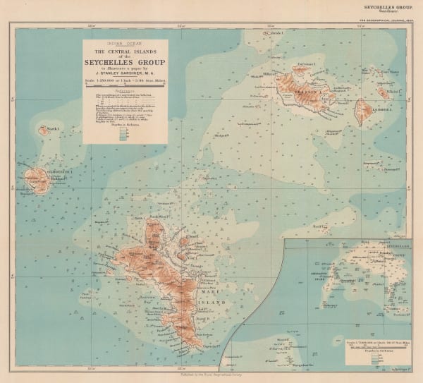
Royal Geographical Society (RGS), The Central Islands of the Seychelles Group, 1907£ 375.00
-
-
Royal Geographical Society (RGS), Nanda Devi National Park, Himalayas, 1908£ 295.00
-
Edward Stanford, Stanford's Portable Map of India, 1908 (c.)£ 995.00
-
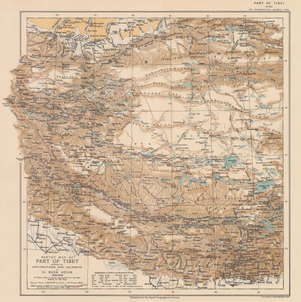
Royal Geographical Society (RGS), Sketch Map of Tibet, 1909£ 325.00
-
G. & J. Bartholomew, Bangladesh (East Bengal), Assam and Bhutan , 1909£ 88.00
-
G. & J. Bartholomew, Southern India - Madras (southern section) , 1909£ 75.00
-
G. & J. Bartholomew, Rajasthan (Rajputana with Ajmer-Merwara), 1909£ 85.00
-
G. & J. Bartholomew, India - Orographical features, 1909£ 78.00
-
G. & J. Bartholomew, Southern India - Andhra Pradesh., 1909£ 65.00
-
G. & J. Bartholomew, Central India, 1909£ 65.00
-
G. & J. Bartholomew, Hyderabad, 1909£ 65.00
-
G. & J. Bartholomew, India - Density of Population, 1909£ 65.00
-
G. & J. Bartholomew, Varanasi (Benares) and environs, 1909£ 75.00
-
G. & J. Bartholomew, Environs of Kolkata (Calcutta), 1909£ 68.00
-
G. & J. Bartholomew, India - Geological features, 1909£ 88.00
-
G. & J. Bartholomew, West Bengal and Sikkim, 1909£ 75.00
-
G. & J. Bartholomew, Uttar Pradesh and Uttarakhand (The United Provinces of Agra and Oudh), 1909£ 68.00
-
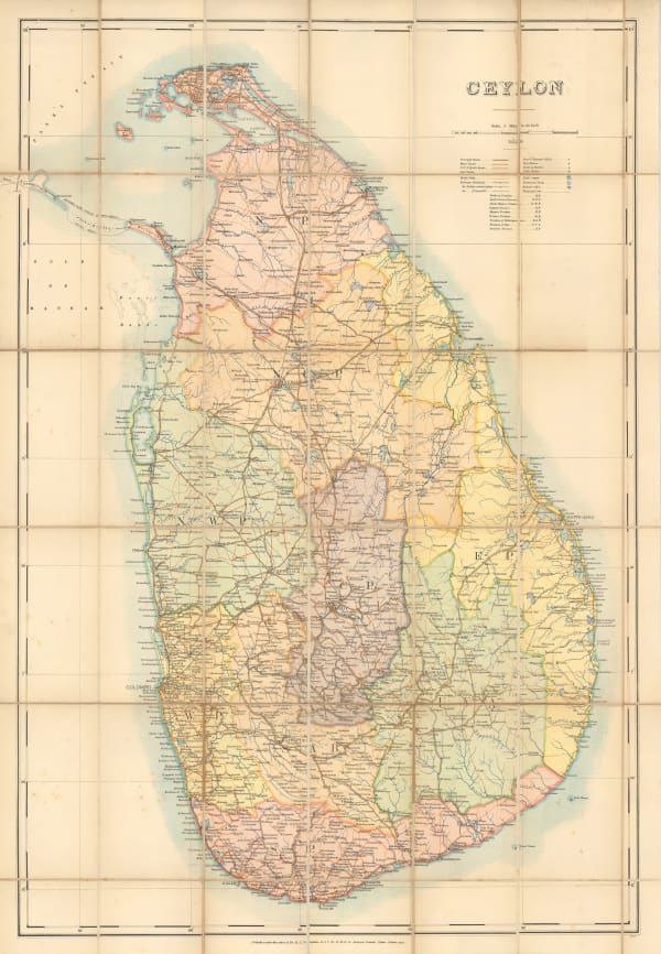
R.S. Templeton, Sri Lanka (Ceylon), 1910£ 850.00
-
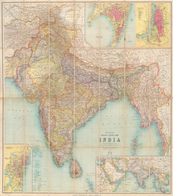
W. Thacker & Co., Reduced Survey Map of India, 1910£ 885.00
-
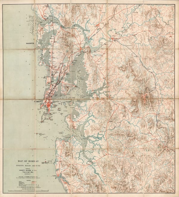
Bennett Coleman & Co, Mumbai (Bombay) and environs, 1910 c.£ 1,150.00
-
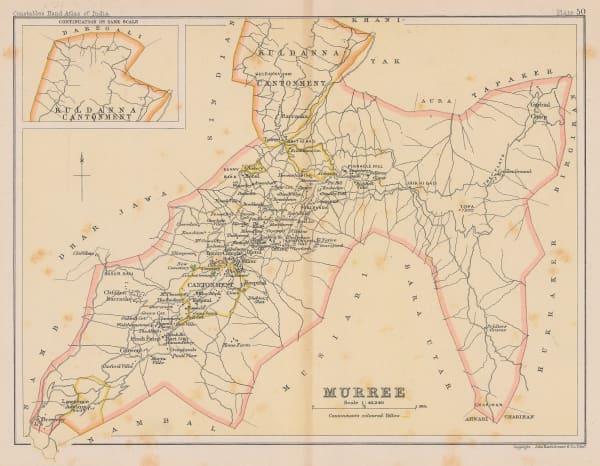
Archibald Constable, Murree, 1910 c.£ 36.00
-
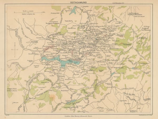
John Murray, Ooty (Ootacamund), 1910 c.£ 26.00
-
George Philip & Son Ltd., The Near East: Industries and Communications, 1910 c.£ 225.00
-
George Philip & Son Ltd., Indian Empire: Industries and Communications, 1910 c.£ 195.00
-
Edward Stanford, Sri Lanka (Ceylon), 1911£ 275.00
-
Marcel Couttreau & H. le Chartier, Sri Lanka, 1911£ 68.00
-
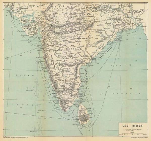
Marcel Couttreau & H. le Chartier, India & Sri Lanka, 1911£ 75.00
-
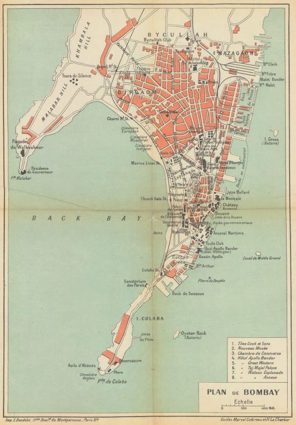
Cottreau & Le Chartier, M & H., Mumbai (Bombay), 1911£ 88.00
-
Cottreau & Le Chartier, M & H., Bombay or Mumbai, 1911£ 95.00
-
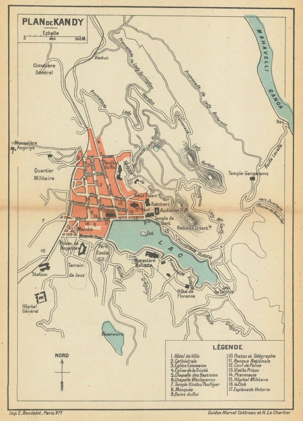
E. Baudelot, Small plan of Kandy, 1911£ 75.00
-
E. Baudelot, Chennai (Madras), 1911£ 72.00
-
Royal Geographical Society (RGS), Chinese Frontiers of India, 1912£ 445.00
-
Joseph Meyer, Kolkata (Calcutta), 1912£ 64.00
-
D.G. Hatchell, Kurnool District map for the use of Touring Officers, 1912£ 495.00


Page
4
of 6