-

-
Claudius Ptolemy & Laurent Fries, Ptolemaic Map of North Africa & Egypt, 1535£ 750.00
-
Martin Waldseemüller & Laurent Fries, West Africa, 1541£ 2,550.00
-
Claudius Ptolemy & Laurent Fries, Algeria, Tunisia & Libya, 1541£ 695.00
-
Early woodcut map of West Africa and the Gulf of Guinea, 1556Giovanni Battista RamusioSeries: VeniceGiovanni Battista Ramusio, Early woodcut map of West Africa and the Gulf of Guinea, 1556£ 3,650.00
-
Girolamo Ruscelli, Early map of Egypt, Libya and Nubia (Sudan), 1561£ 235.00
-
Girolamo Ruscelli, Egypt New Map, 1561£ 265.00
-
Antoine Du Pinet, Very early woodcut view of Algiers, 1564£ 425.00
-
Heinrich Petri, Ptolemaic Map of Africa, 1564 c.£ 195.00
-
-
Giulio & Livio Sanuto, Rare Ptolemaic Map of North Africa, 1588£ 985.00
-
Giulio & Livio Sanuto, Africae Tabvla VIII, 1588£ 985.00
-
Georg Braun & Frans Hogenberg, Casablanca, Azemmour, Diu & Goa, 1590 c.£ 1,750.00
-
Abraham Ortelius, Turkey, Egypt, and Carthage (Tunis), 1592£ 950.00
-
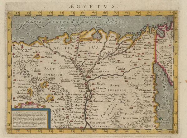
Giovanni Antonio Magini, Early map of Egypt and the Nile Delta, 1596£ 325.00
-
Giovanni Antonio Magini, North Africa, 1596£ 145.00
-
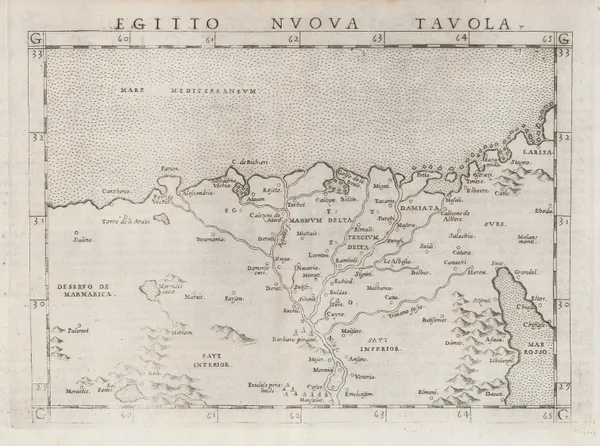
Giuseppe Rosaccio, Early map of Egypt and the Nile Delta, 1599£ 350.00
-
Giuseppe Rosaccio, North Africa, 1599£ 165.00
-
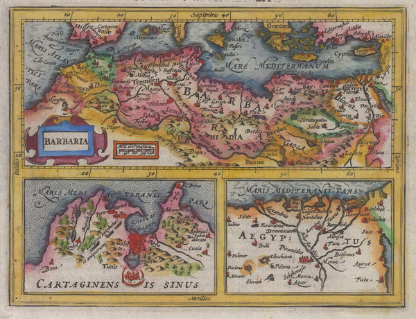
Abraham Ortelius, Northern Africa or Barbary Coast, 1601£ 1,850.00
-
Petrus Bertius, Miniature map of Egypt and the Nile delta, 1616£ 225.00
-
Petrus Bertius, Red Sea, 1616£ 395.00
-
Mercator Hondius, Dutch Golden Age map of Morocco, 1620 c£ 845.00
-
Samuel Purchas, North Africa, Egypt and Tunis, 1625£ 325.00
-
Samuel Purchas, Early map of Morocco, 1625£ 285.00
-
Samuel Purchas, Early map of southern Morocco, 1625£ 295.00
-
Mercator Hondius, North Africa, Egypt and Tunis, 1635£ 245.00
-
Willem & Jan Blaeu, Morocco orientated east to west, 1650 c.£ 925.00
-
Nicolas Sanson, Kingdom of Morocco, 1655£ 675.00
-
Jan Jansson, North Africa during the Classical Era, 1661£ 145.00
-
Olfert Dapper, Morocco orientated east to west, 1670£ 425.00
-
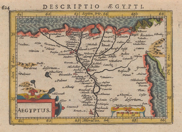
Petrus Montanus, Egypt oriented east to west, 1673 c.£ 425.00
-
Pierre Duval, Egypte, 1680 c.£ 115.00
-
Nicolas Sanson, Egypt divided into twelve governorates, 1683£ 195.00
-
Nicolas & Guillaume Sanson, Egypt & Libya, 1683£ 325.00
-
Robert Morden, Miniature map of Morocco, 1688£ 225.00
-
Robert Morden, Miniature map of Egypt, 1688£ 275.00
-
Robert Morden, Of Barbary, 1688£ 165.00
-
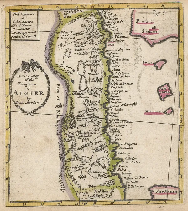
Robert Morden, A New Map of the Kingdome of Algier, 1688£ 225.00
-
Johannes van Keulen, Western Sahara coast, 1690 c.£ 525.00
-
Johannes van Keulen, Chart of the Western coast of Morocco, 1690 c.£ 525.00
-
Johann Ulrich Muller, Miniature map of Libya and Egypt, 1692£ 120.00
-
Johann Ulrich Muller, Ancient kingdoms of Biledulgerid and Zara, 1692£ 150.00
-
Johann Ulrich Muller, Miniature map of Egypt, 1692£ 125.00
-
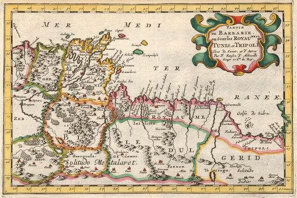
Partie de la Barbarie ou son les Royaumes de Tunis et Tripoli, 1692Nicolas & Guillaume SansonSeries: ParisNicolas & Guillaume Sanson, Partie de la Barbarie ou son les Royaumes de Tunis et Tripoli, 1692£ 165.00
-
Nicolas & Guillaume Sanson, Southern Morocco, 1692£ 195.00
-
Johann Ulrich Muller, Northern Africa, 1692£ 145.00
-
Nicolas Sanson, West and Northwest Africa, 1692£ 375.00
-
Nicolas & Guillaume Sanson, Ethiopia & Nubia, 1692£ 245.00
-
Pierre Duval, Miniature map of the coast of North Africa, 1694£ 92.00
-
Nicolas Sanson, Kingdom of Fez (northern Morocco), 1700£ 345.00
-
Nicolas & Guillaume Sanson, Southern Morocco and Western Sahara, 1700£ 325.00
-
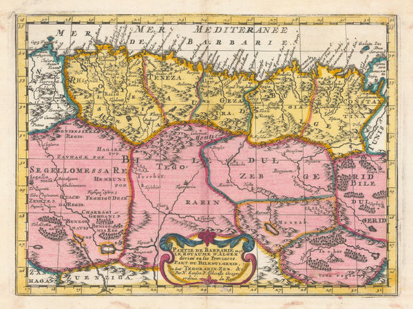
Nicolas & Guillaume Sanson, Partie de Barbarie en est le Royaume d'Alger., 1700£ 350.00
-
Robert Morden, North & West Africa, 1702£ 175.00
-
Nicolas de Fer, Northeast Africa, 1705£ 420.00
-
Nicolas de Fer, West Africa, 1705£ 295.00
-
Guillaume De L'Isle, North & West Africa, 1707£ 445.00
-
Pierre Mortier, Sea Chart of West Africa & Atlantic Islands, 1708£ 1,350.00
-
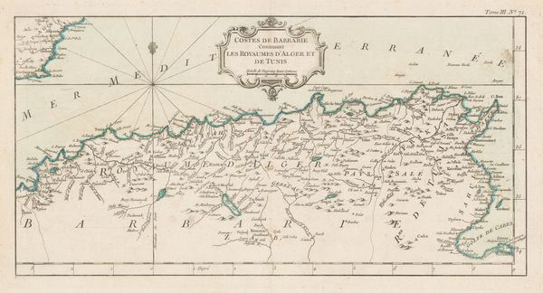
Pierre Mortier, Chart of the southern Mediterranean and coast of North Africa, 1708£ 3,000.00
-
Samuel Thornton, Northwest coast of Africa, 1711£ 950.00
-
Philipp Cluver, North-western Africa, 1711£ 98.00
-
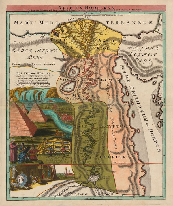
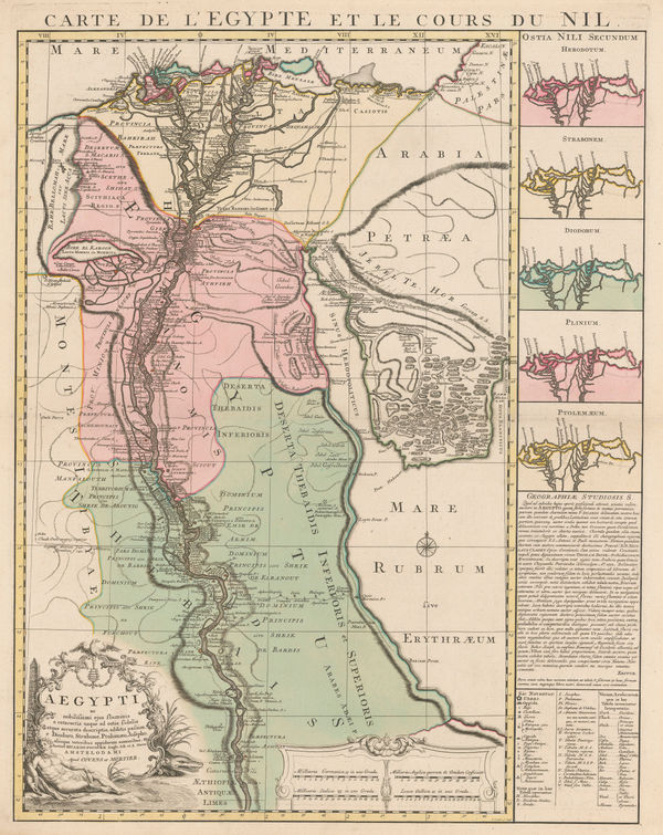
Johann Baptist Homann, Egypt and the course of the Nile, 1720 c.£ 1,950.00
-
Western Mediterranean, Coast of Spain and Algeria, 1723Henri Michelot and Laurent BrémondSeries: MarseillesHenri Michelot and Laurent Brémond, Western Mediterranean, Coast of Spain and Algeria, 1723£ 1,550.00
-
Guillaume De L'Isle, De L'Isle's famous map of Senegal, 1727£ 475.00
-
Herman Moll, The Turkish Empire in Europe, Asia and Africa, 1730 c£ 4,450.00
-
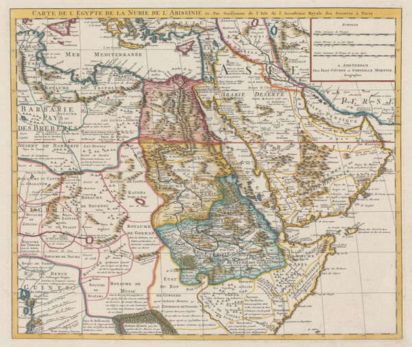
Northeast Africa and the Arabian Peninsula, 1730 c.Covens (Jean) & Mortier (Cornelius)Series: AmsterdamCovens (Jean) & Mortier (Cornelius), Northeast Africa and the Arabian Peninsula, 1730 c.£ 735.00
-
Herman Moll, North Africa, 1755 c.£ 155.00
-
Covens (Jean) & Mortier (Cornelius), Egypt and the Nile, 1757 c.£ 1,250.00
-
London Magazine, Morocco divided into the four historic kingdoms, 1760£ 85.00
-
Robert de Vaugondy, North and West Africa, 1762£ 165.00
-
Jacques-Nicolas Bellin, The Nile Delta, 1764£ 55.00
-
Jacques-Nicolas Bellin, Gulf of Tunis, 1764£ 115.00
-
Jacques-Nicolas Bellin, Chart of Tabarka Island, Tunisia, 1764£ 60.00
-
Jacques-Nicolas Bellin, Arguin Island, Mauritania, 1764£ 85.00
-
Jacques-Nicolas Bellin, Chart of Tripoli harbour, 1764£ 125.00
-
Jacques-Nicolas Bellin, Chart of Mers El Kébir harbour and castle, 1764£ 65.00
-
Jacques-Nicolas Bellin, Algiers, 1764£ 145.00
-
Jacques-Nicolas Bellin, Algeria & Tunisia, 1764£ 175.00
-
Jacques-Nicolas Bellin, Tunis, 1764£ 195.00
-
Jacques-Nicolas Bellin, The Egyptian Coast from Alexandria to Rosetta, 1764£ 195.00
-
Jacques-Nicolas Bellin, Morocco & Western Sahara, 1764£ 145.00


Page
1
of 3