-
 Rigobert Bonne, Coast of North Africa and southern Mediterranean, 1771 c.£ 225.00
 -
Carsten Niebuhr, Chart of Suez, 1779£ 175.00
-
Carsten Niebuhr, The Gulf of Suez and the Sinai Peninsula, 1779£ 225.00
-
Robert Sayer, Ancient Egypt, 1780 c.£ 195.00
-
Rigobert Bonne, Northwest Africa coast, Tangier to Sierra Leone, 1780 c.£ 90.00
-
Jean Lattre, Egypt, Sudan and Ethiopia, 1782£ 75.00
-
Willem Albert Bachiene, Coast of North Africa, 1783£ 485.00
-
John Harrison, Egypt and the course of the Nile, 1788£ 145.00
-
Laurie & Whittle, Egypt and the Nile, 1794£ 275.00
-
William Faden, North Africa from Morocco to Libya, 1798£ 92.00
-
John Brydon, Battle of the Nile, 1798£ 4,950.00
-
William Faden, Nile Delta, 1802£ 675.00
-
George & John Cary, Egypt and the Nile delta, 1805£ 365.00
-
John Pinkerton, Northern Africa, 1811£ 325.00
-
John Pinkerton, Western Africa, 1813£ 475.00
-
John Thomson, North Africa, 1814£ 315.00
-
Christian Gottlieb Reichard, North-western Africa, 1818£ 75.00
-
Thomas Myers, Egypt, 1821£ 78.00
-
French Admiralty, Chart of the town and harbour of Tripoli, Libya, 1823£ 285.00
-
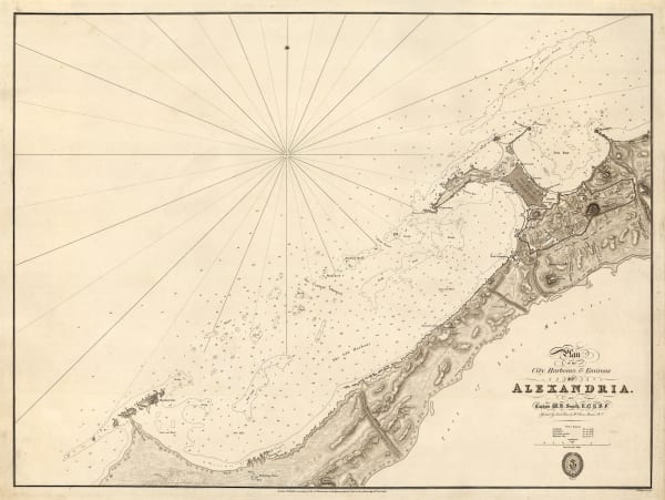
British Admiralty, Plan of the City, Harbours, & Environs of Alexandria, 1825£ 500.00
-
Maj. Dixon Denham, Map of the Travels and Discoveries made in Northern and Central Africa, 1826£ 395.00
-
Charles Smith, Map of North Africa Intended to Illustrate the Progress of Discovery in that Country, 1828£ 495.00
-
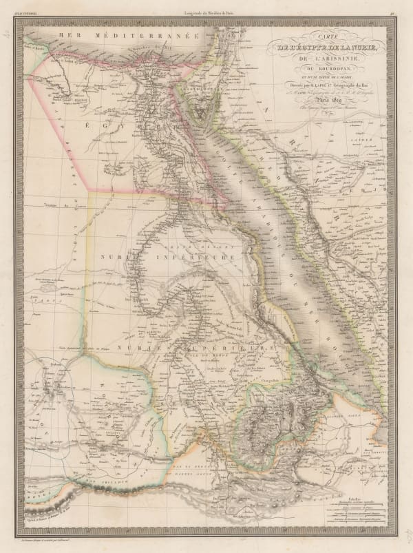
Alexandre Emile Lapie, Egypt, the Nile Valley, Sudan, Eritrea, and parts of Ethiopia, 1829£ 140.00
-
Thomas Starling, Egypt, 1830 c.£ 64.00
-
Society for the Diffusion of Useful Knowledge (SDUK), Ancient Egypt, 1831£ 120.00
-
Society for the Diffusion of Useful Knowledge (SDUK), Egypt, 1831£ 80.00
-
Royal Geographical Society (RGS), Morocco and Marrakesh, 1831£ 395.00
-
British Admiralty, Chart of the North Coast of Africa from Ras al Halal to Alexandria, 1833£ 180.00
-
Society for the Diffusion of Useful Knowledge (SDUK), Algerian coast from Bonah to Magrowah, 1834£ 86.00
-
British Admiralty, Plan of the Harbour of Tripoli, 1835£ 300.00
-
Daniel & William Lizars, Egypt, 1835 c.£ 245.00
-
Royal Geographical Society (RGS), Coast of Morocco and Western Sahara, 1836£ 65.00
-
Rest Fenner, Egypt, 1836£ 75.00
-
Royal Geographical Society (RGS), Route of Sir Grenville Temple from Bonah to Kostantinah, 1838£ 58.00
-
James Wellsted, Mount Sinai Peninsula, 1838£ 395.00
-
Royal Geographical Society (RGS), The Nile from Essuan to Al-Leis to Illustrate a Journey to Kordofan, 1839£ 85.00
-
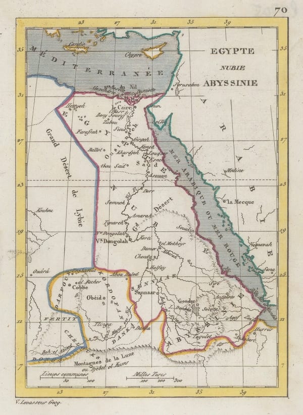
Victor Levasseur, Miniature map of north-eastern Africa, 1840 c.£ 35.00
-
Royal Geographical Society (RGS), West Coast of Africa, 1840 c.£ 125.00
-
John Arrowsmith, Egypt, 1842£ 185.00
-
James Wyld, Lower Egypt or the Nile Delta, 1842£ 285.00
-
Royal Geographical Society (RGS), Natron Lakes of Egypt, 1843£ 145.00
-
Joseph Meyer, Egypt, the Nile and Nubia (Sudan), 1844£ 115.00
-
Joseph Meyer, Tunisia, 1844£ 175.00
-
Joseph Meyer, Morocco, 1844£ 195.00
-
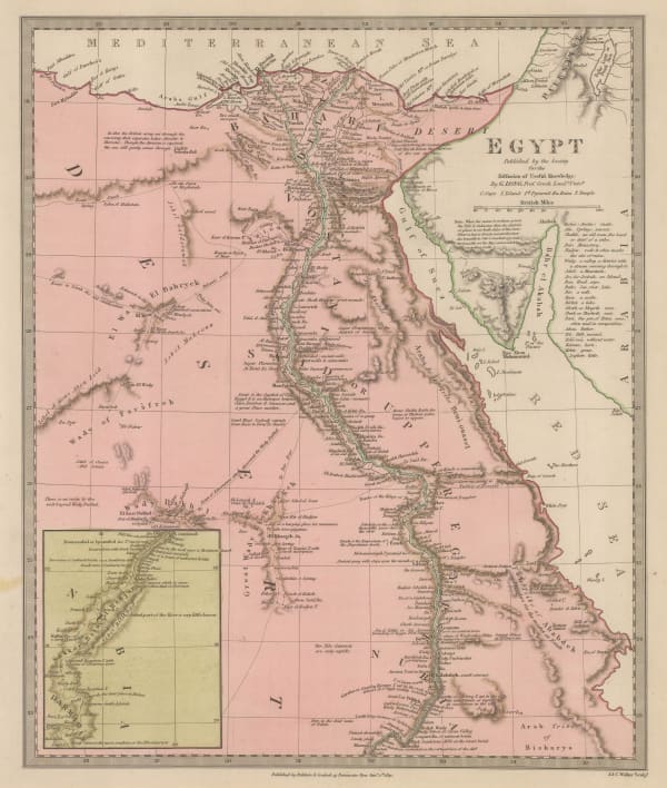
Henry Teesdale, Egypt, 1845£ 145.00
-
Samuel Augustus Mitchell, Egypt, 1847 c.£ 285.00
-
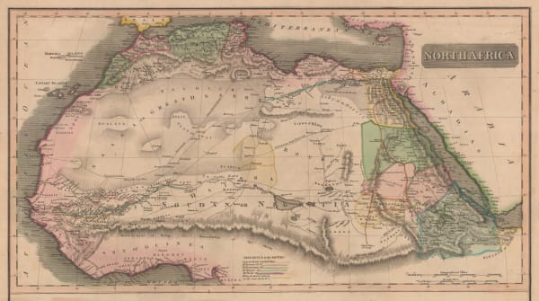
John Tallis, Northern Africa, 1851£ 275.00
-
Charles V. Monin, Egypt, Sudan, South Sudan, Eritrea and part of Ethiopia, 1853£ 44.00
-
Sir Archibald Alison, Battle of The Nile, 1855£ 525.00
-
Royal Geographical Society (RGS), North Africa - Map Showing the Caravan routes between Tripoli and Ghadamis, 1859£ 125.00
-
Justus Perthes, The Red Sea, 1860£ 78.00
-
Victor Levasseur, Algérie (Northern Algeria), 1860 c.£ 195.00
-
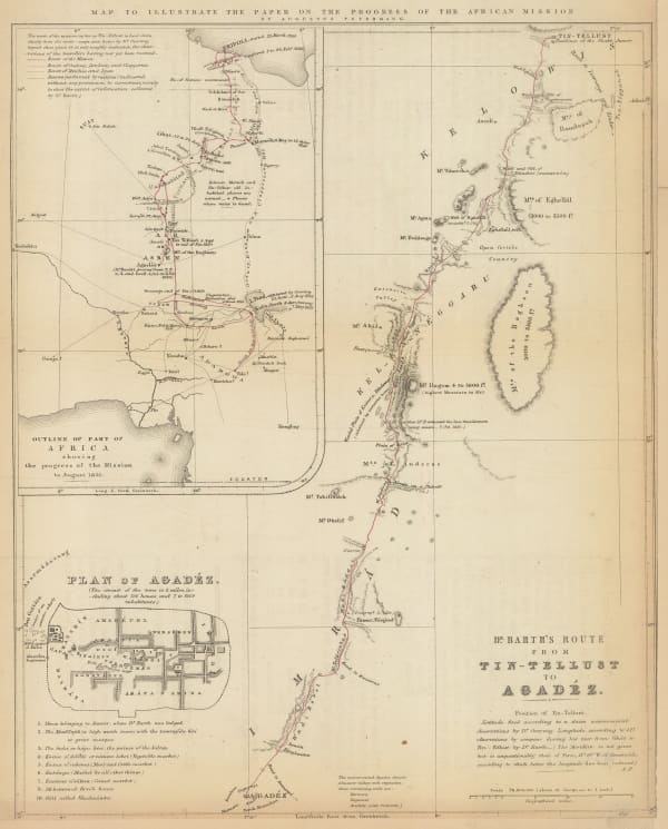
Royal Geographical Society (RGS), Dr. Barth's Route from Tin-Tellust to Agadez, 1860 c.£ 185.00
-
Archibald Fullarton, Lower Egypt, 1860 c.£ 40.00
-
Justus Perthes, Sahara, 1861£ 62.00
-
Justus Perthes, Sudan & Egypt, 1862£ 115.00
-
Edward Weller, Egypt, Nubia, Abyssinia and the Red Sea, 1863£ 125.00
-
Justus Perthes, Algeria and Libya, 1863£ 65.00
-
Justus Perthes, Northern Morocco, 1865£ 68.00
-
Justus Perthes, Egypt and Nubia (Sudan), 1869£ 40.00
-
Alexandre Vuillemin, Folding map of Algeria, 1871£ 295.00
-
Justus Perthes, French military expeditions in Morocco, 1872£ 68.00
-
Carl Muller, North Africa coast during the Classical period, 1873£ 50.00
-
Society for the Diffusion of Useful Knowledge (SDUK), North Africa or Barbary I - Marocco, 1875£ 185.00
-
Justus Perthes, Expeditions in the Libyan Desert, 1875£ 185.00
-
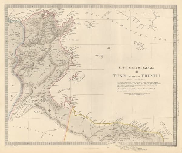
Society for the Diffusion of Useful Knowledge (SDUK), North Africa or Barbary - Tunis and Part of Tripoli, 1879£ 98.00
-
Society for the Diffusion of Useful Knowledge (SDUK), North Africa or Barbary - Parts of Egypt and Tripoli, 1879£ 98.00
-
A. Simon, Port of Alexandria, 1882£ 325.00
-
Service géographique de l'armée, Folding wall map of Egypt , 1883£ 2,450.00
-
Guido Cora, Italian city plan of Marrakech, 1884£ 325.00
-
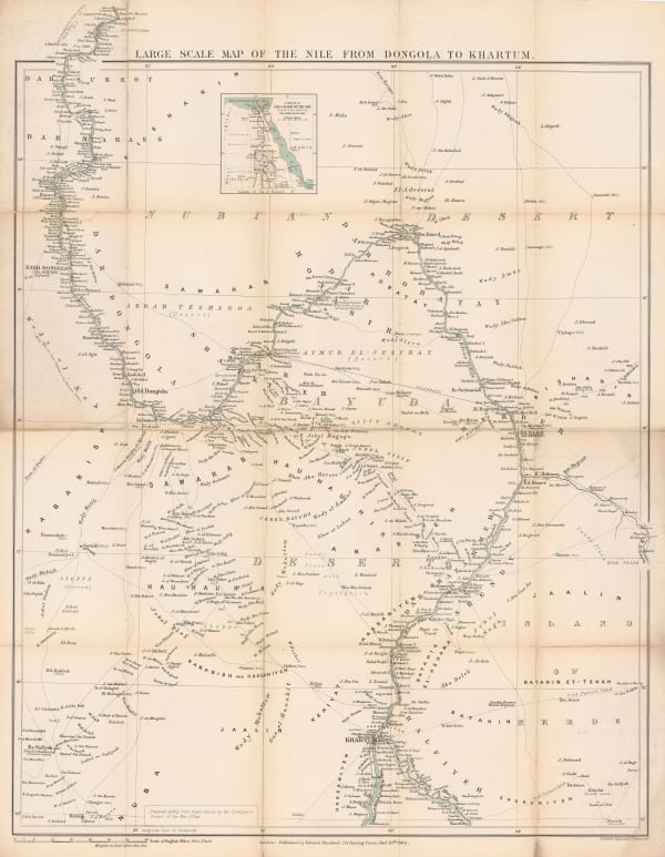
Royal Geographical Society (RGS), Sketch Map of Egypt, Nubia and Egyptian Sudan, 1884£ 145.00
-
Edward Stanford, A Map of the Nile during the Siege of Khartoum, 1884£ 345.00
-
A. Simon, Port Said harbour, 1885£ 175.00
-
A. Simon, Algier. (1886), 1886£ 175.00
-
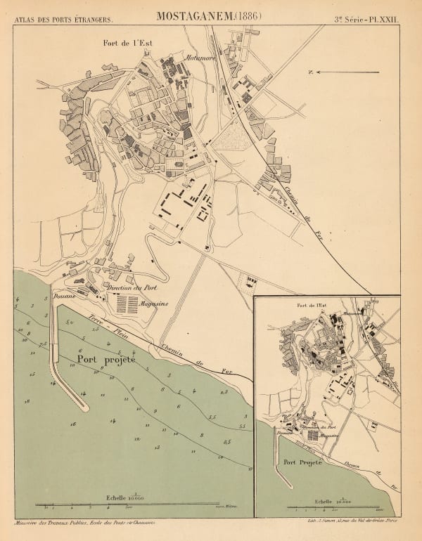
A. Simon, Mostaganem. (1886), 1886£ 62.00
-
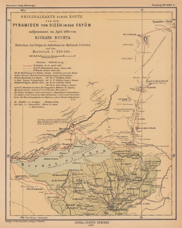
Justus Perthes, Sketch map of Faiyum and the Pyramids of Giza, 1887£ 68.00
-
A. Simon, Tunis et ses Abords, 1888£ 175.00
-
Royal Geographical Society (RGS), Northwest Morocco showing desert tribes, 1889£ 95.00
-
Royal Geographical Society (RGS), Map of South Western Morocco, 1889£ 45.00
-
Gaston Chaumelin, Folding wall map of the Suez Canal, 1889£ 1,850.00


Page
2
of 3