-

-
-
Sebastian Münster, Elizabethan London, 1598 c.£ 2,500.00
-
Willem & Jan Blaeu, Middlesex, or North & West London, 1650 c.£ 725.00
-
An 1863 Reprint of Newcourt's Pre-Fire Map of London, 1658 (1863)Richard Newcourt & Edward StanfordSeries: LondonRichard Newcourt & Edward Stanford, An 1863 Reprint of Newcourt's Pre-Fire Map of London, 1658 (1863)£ 4,500.00
-
Matthäus Merian, The Great Fire of London, 1670 c.£ 1,500.00
-
Matthäus Merian, London after the Great Fire, 1677 c.£ 1,950.00
-
-
Vincenzo Coronelli, London, 1696£ 2,250.00
-
Nicolas de Fer, London & Westminster, 1700£ 885.00
-
Herman Moll, London and its Environs 20 Miles Around, 1700 c.£ 375.00
-
Johann Baptist Homann, Map and Panoramic View of London, 1700 c.£ 4,950.00
-
Edward Hatton, A New Map of the Cityes of London, Westminster & Southwark, 1708£ 3,850.00
-
Edward Hatton, A Plan of London, Westminster and Southwark, 1708£ 4,950.00
-
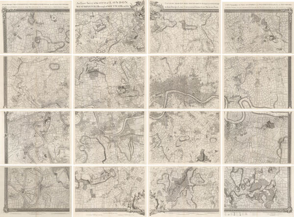
Morden & Lea, Actuale Survey of London, 1710 c.£ 4,850.00
-
Nouvelle Carte du Gouvernement Civil d'Angleterre et Celuy de la Ville de Londres, 1719Henri ChatelainSeries: ParisHenri Chatelain, Nouvelle Carte du Gouvernement Civil d'Angleterre et Celuy de la Ville de Londres, 1719£ 250.00
-
George Willdey, London and 30 Miles Around, 1720 c.£ 2,450.00
-
Gabriel Bodenehr, London, Westminster & Southwark, 1720 c.£ 885.00
-
Pieter van der Aa, London after the Glorious Revolution, 1720 c.£ 3,950.00
-
-
George Vertue, London during the English Civil War, 1738£ 395.00
-
Matthaus Seutter, London and its Environs, 1740 c.£ 1,850.00
-
Regionis, qvae est circa Londinvm specialis repraesentatio geographica, 1741Homann HeirsSeries: NurembergHomann Heirs, Regionis, qvae est circa Londinvm specialis repraesentatio geographica, 1741£ 1,650.00
-
Georges-Louis Le Rouge, Les Environs de Londres, 1745£ 895.00
-
-
Isaac Tirion, Kaart van Londen, 1754£ 1,350.00
-
A Plan of the City and Liberties of London after the Dreadful Conflagration in the Year 1666, 1756Emanuel BowenSeries: LondonEmanuel Bowen, A Plan of the City and Liberties of London after the Dreadful Conflagration in the Year 1666, 1756£ 625.00
-
-
Jacques-Nicolas Bellin, Plan de la Ville de Londres, 1764£ 595.00
-
The London Directory, or a New & Improved Plan of London, Westminster, & Southwark, 1784Robert WilkinsonSeries: LondonRobert Wilkinson, The London Directory, or a New & Improved Plan of London, Westminster, & Southwark, 1784£ 1,350.00
-
A New and Correct Plan of the Citie of London, Westminster and Borough of Southwark, 1785Robert SayerRobert Sayer, A New and Correct Plan of the Citie of London, Westminster and Borough of Southwark, 1785£ 1,850.00
-
A Plan of the Cities of London and Westminster, The Borough of Southwark and their Suburbs, 1785William FadenWilliam Faden, A Plan of the Cities of London and Westminster, The Borough of Southwark and their Suburbs, 1785£ 2,750.00
-
-
George Bickham, Bird's-Eye view of London, 1796£ 550.00
-
John Stockdale, The Proposed London Docks, 1796£ 650.00
-
New Pocket Plan of the Cities of London and Westminster with the Borough of Southwark, 1800Bowles & CarverSeries: LondonBowles & Carver, New Pocket Plan of the Cities of London and Westminster with the Borough of Southwark, 1800£ 895.00
-
Richard Phillips, London, 1802£ 795.00
-
Plan des Villes de Londres et Westminster et du Bourg de Southwark, 1802Bureau d'IndustrieSeries: WeimarBureau d'Industrie, Plan des Villes de Londres et Westminster et du Bourg de Southwark, 1802£ 795.00
-
Depot de la Guerre, Napoleonic Invasion Map of London, 1804£ 3,500.00
-
Charles Smith, New Plan of London, Westminster and Southwark, 1805£ 1,350.00
-
James Stratford, London, 1806£ 895.00
-
James Stratford, London and Environs, 1808£ 295.00
-
Edward Mogg, An Entire New Plan of the Cities of London and Westminster, 1809£ 1,650.00
-
Daniel Paterson, Paterson's Twenty-Four Miles Round London, 1809£ 1,850.00
-
-
Laurie & Whittle, New Map of London with its Environs, 1817£ 1,950.00
-
William Faden, A New Topographical Map of the Country in the Vicinity of London, 1818£ 2,650.00
-
Longman & Co., London and its Environs, 1818£ 825.00
-
Ambroise Tardieu, Plan de Londres avec le Bourg de Southwark, 1820 c.£ 775.00
-
Edward Mogg, Forty Five Miles Around London, 1821£ 750.00
-
William Faden, A Plan of London and Westminster with the Borough of Southwark, 1822£ 985.00
-
Edward Wallis, Guide for Strangers through London, 1822£ 1,550.00
-
John Luffman, The Metropolis Displayed or Langley's Faithful Guide through London, 1822£ 2,450.00
-
William Faden, Plan of London and Westminster and the Borough of Southwark, 1823£ 2,450.00
-
Stephen William Cooke, A New Plan of London and its Environs, 1823£ 1,700.00
-
Charles Smith, Map of the Country Fifteen Miles around London, 1823£ 1,250.00
-
Sholto and Reuben Percy, A New Map of London, Westminster and Southwark, 1823£ 395.00
-
James Pigot, Pigot & Co.'s New Plan of London, 1823 (c.)£ 2,450.00
-
George Frederick Cruchley, Environs of London, 1824£ 1,550.00
-
A Plan of the Cities of London & Westminster, the Borough of Southwark with the New Buildings, 1824James WyldJames Wyld, A Plan of the Cities of London & Westminster, the Borough of Southwark with the New Buildings, 1824£ 2,950.00
-
Charles Smith, Map of the Country Twelve Miles around London, 1825£ 1,750.00
-
George Frederick Cruchley, Cruchley's New Plan of London, 1828£ 800.00
-
Charles Smith, Smith's London, 1830 c.£ 695.00
-
Thomas Tegg, New Plan of London &c. with 360 References to the Principal Streets, 1831£ 875.00
-
Pigot & Co's New Map of the Environs of London, Extending 14 Miles Round St. Paul's in Every Direction, 1832James PigotSeries: ManchesterJames Pigot, Pigot & Co's New Map of the Environs of London, Extending 14 Miles Round St. Paul's in Every Direction, 1832£ 1,650.00
-
Society for the Diffusion of Useful Knowledge (SDUK), The Environs of London, 1832£ 445.00
-
New Plan of London &c. with 360 references to the Principal Streets, 1832 c.Thomas TeggSeries: LondonThomas Tegg, New Plan of London &c. with 360 references to the Principal Streets, 1832 c.£ 950.00
-
George Frederick Cruchley, New Map of London, 1833£ 1,295.00
-
John Walter Froggett, Froggett's Survey of the Country Thirty Miles Round London, 1833£ 3,950.00
-
-
George & John Cary, Cary's New Plan of London and its Vicinity, 1836£ 2,250.00
-
James Wyld, Environs of London, 1838£ 1,550.00
-
Samuel Lewis, A Plan of London and its Environs, 1840 c.£ 750.00
-
-
James Wyld, Plan of London and Westminster, 1841£ 2,000.00
-
Edward Wallis, Wallis's Guide for Strangers through London, 1843£ 1,350.00
-
James Wyld, A New Topographical Map of the Country in the vicinity of London, 1843£ 2,650.00
-
Richard Holmes Laurie, Laurie's Plan of London, Westminster, and Southwark, 1843£ 3,450.00
-
Edward Mogg, London in Miniature with Surrounding Villages, 1844£ 1,850.00
-


Page
1
of 3