-
 John Speed, Jersey, Guernsey, Holy Island & Farne Islands, 1611£ 3,250.00
 -
John Speed, Jersey, Guernsey, Farne Islands & Holy Island, 1614£ 595.00
-
John Speed, Jersey, Guernsey, Holy Island & Farne Islands, 1627£ 550.00
-
Mercator Hondius, Jersey, Guernsey, Isle of Wight & Anglesey, 1635£ 195.00
-
Richard Blome, A Mapp of the Isles of Wight, Iarsey, Garnsey, Sarke, Man, Orcades, and Shetland, 1673£ 265.00
-
Pierre Mortier, 2me. Carte Particuliere des Costes de Normandie, Contenant les Costes du Cotentin, 1708£ 925.00
-
Jean de Beaurain, Carte Generale des Isles Grenesey, Jersey, Aurigny, Chausey, &c, 1757£ 2,250.00
-
Jean de Beaurain, Carte Topo-Hidro-Graphique de l'Isle de Jersey, 1757£ 2,850.00
-
William Faden, A Chart of the Islands of Jersey and Guernsey, Sark, Herm and Alderney, 1781£ 2,250.00
-
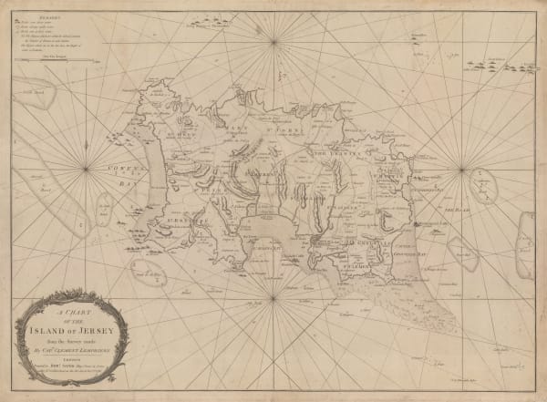
Robert Sayer, A Chart of the Island of Jersey, 1786£ 1,850.00
-
Franz Von Reilly, Die Insel Guernsey, 1790 c.£ 345.00
-
Mahmoud Raif Efendi, Rare Ottoman Map of the Channel Islands, 1804£ 2,200.00
-
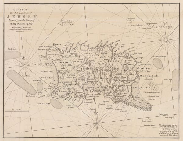
John Cary, A Map of the Island of Jersey, 1805£ 395.00
-
John Pinkerton, Remote British Isles, 1814£ 225.00
-
John Rapkin, Channel Islands, 1850 c.£ 125.00
-
John Tallis, Channel Islands, 1851£ 295.00
-
Archibald Fullarton, General Map of Channel Islands, 1860 c.£ 86.00
-
Edward Stanford, The Channel Islands, 1896£ 75.00
-
British Admiralty, Guernsey, Herm and Sark, 1927£ 675.00
-
British Admiralty, Island of Jersey, 1927£ 675.00
-
British Admiralty, The Channel Islands and Adjacent Coasts of France, 1928£ 675.00
-
French Admiralty, Carte Particuliere Des Iles Guernsey, Herm et Serk, 1930£ 675.00
-
F. Mahon-Brown, Jersey, 1948£ 450.00
Close
Search Inventory
Our entire inventory of over 10,000 antique and vintage maps is now available to browse by region, date, cartographer, and subject


Join our mailing list
* denotes required fields
We will process the personal data you have supplied to communicate with you in accordance with our Privacy Policy. You can unsubscribe or change your preferences at any time by clicking the link in our emails.
![]()