-

-
-
-
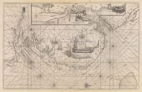
Lucas Waghenaer, Description des Costes Marines d'Angleterre, entre Pleymouth & Portlandt, avec les principaulx haures d'icelles, 1590£ 3,500.00
-
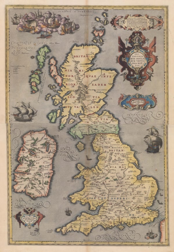
Abraham Ortelius, Great Britain & Ireland in Bright Original Colour, 1592£ 3,850.00
-
Tomaso Porcacchi, Miniature Map of Britain & Ireland, 1604£ 495.00
-
John Speed, Jersey, Guernsey, Holy Island & Farne Islands, 1611£ 3,250.00
-
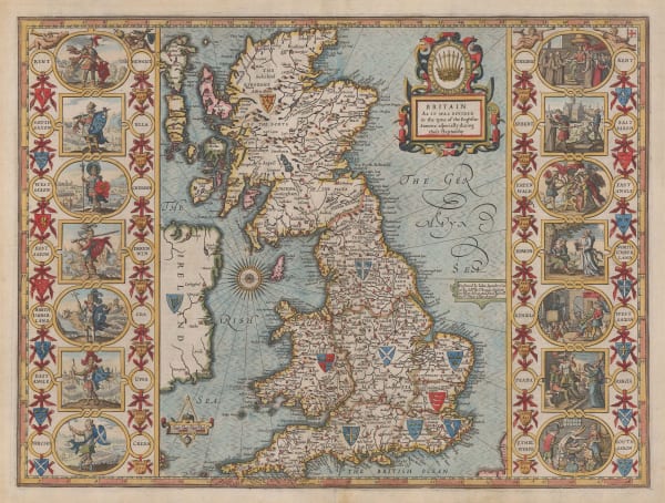
John Speed, The Kingdom of Great Britain and Ireland, 1611£ 4,250.00
-
John Speed, The Kingdome of Great Britaine and Ireland, 1614£ 4,500.00
-
John Speed, Jersey, Guernsey, Farne Islands & Holy Island, 1614£ 595.00
-
Giovanni Antonio Magini, Miniature Map of Great Britain & Ireland, 1617£ 445.00
-
Petrus Bertius, Miniature Map of the British Isles, 1620 c.£ 445.00
-
Sebastian Münster, Rare Variant of Munster's Map of Britain, 1621£ 1,550.00
-
David Custodis, Uncommon Map of the British Isles, 1627£ 695.00
-
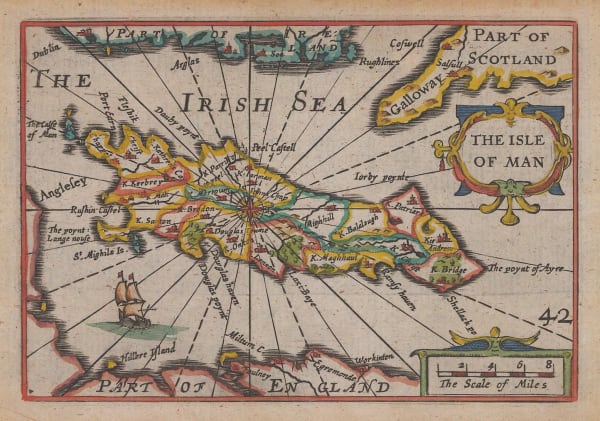
Pieter van den Keere, The Isle of Man, 1627£ 225.00
-
John Speed, Jersey, Guernsey, Holy Island & Farne Islands, 1627£ 550.00
-
Mercator Hondius, Great Britain & Ireland, 1630£ 475.00
-
Mercator Hondius, Jersey, Guernsey, Isle of Wight & Anglesey, 1635£ 195.00
-
Henricus Hondius, Dutch Golden Age Map of Britain, 1642£ 3,750.00
-
Wenceslaus Hollar, Rare Allegorial Map of Britain during the Civil War, 1643 c.£ 4,950.00
-
-
Jan Jansson, Dutch Golden Age Map of Britain, 1648 c.£ 975.00
-
Willem & Jan Blaeu, Dutch Golden Age Map of Britain, 1650 c.£ 1,850.00
-
Jan Jansson, Historical Map of Britain during Roman Times, 1661£ 325.00
-
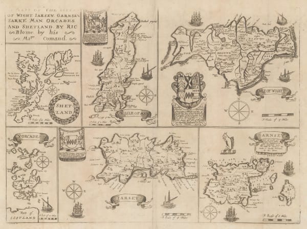
Richard Blome, A Generall Mapp of the Isles of Brittaine, 1669£ 985.00
-
Richard Blome, Isles of Wight, Channel Islands, Isle of Man, Orkneys and Shetland, 1673£ 265.00
-
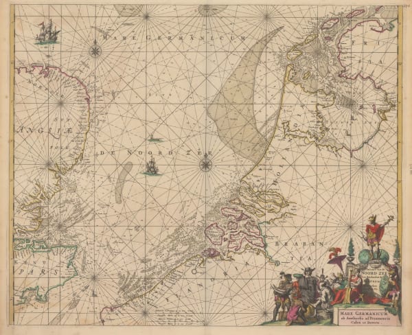
Frederick De Wit, Pascaert van de Noord Zee | Mare Germanicum ad Amelandia ad Promontoria Caleti et Doverae, 1675£ 1,650.00
-
John Speed, Anglo-Saxon Britain, 1676£ 4,750.00
-
Theodore Danckerts, Kingdom of Great Britain, 1685 c.£ 1,950.00
-
Robert Morden, England Scotland and Ireland, 1688£ 425.00
-
Pieter Schenk, Kingdom of Great Britain, 1690 c.£ 895.00
-
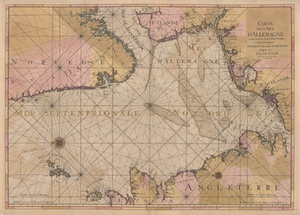
Pierre Mortier, Carte de la Mer d'Allemagne, 1693£ 950.00
-
Nicolas Sanson, British Isles, 1700£ 575.00
-
Guillaume De L'Isle, The British Isles, 1702£ 925.00
-
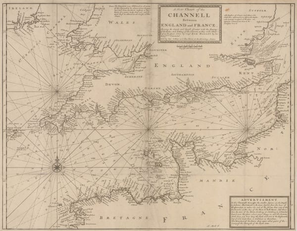
Herman Moll, A New Chart of the Channell between England and France, 1705 c.£ 625.00
-
Jean Baptiste Nolin, The British Isles, 1707 c.£ 550.00
-
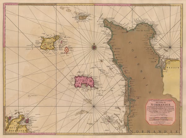
Pierre Mortier, Channel Islands and coast of Normandy, 1708£ 925.00
-
Robert Morden, Smaller British Islands, 1708£ 125.00
-
Johann Baptist Homann, Great Britain & Ireland, 1713 c.£ 895.00
-
Sea Chart of East Anglia from the Thames to the Humber, 1720 c.Capt. Greenvile CollinsSeries: LondonCapt. Greenvile Collins, Sea Chart of East Anglia from the Thames to the Humber, 1720 c.£ 950.00
-
Herman Moll, A New Map of Great Britain, 1733 c£ 3,500.00
-
Matthaus Seutter, Tabula Novissima Accuratissima Regnorum Angliae, Scotiae Hiberniae, 1735 c.£ 895.00
-
Nicolas Berey, Carte Particuliere des Costes Meridionales d'Angleterre qui comprend l'Isle de Wicht, 1740 c£ 1,650.00
-
Mount & Page, A New and Correct Chart of England, Scotland and Ireland, 1740 c.£ 895.00
-
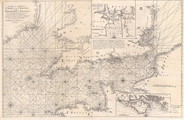
Mount & Page, A New and Correct Chart of the Channel, 1740 c.£ 1,750.00
-
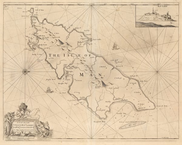
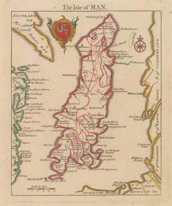
Capt. Greenvile Collins, Isle of Man, 1740 c.£ 1,150.00
-
Isaac Tirion, New Map of the British Isles, 1743£ 545.00
-
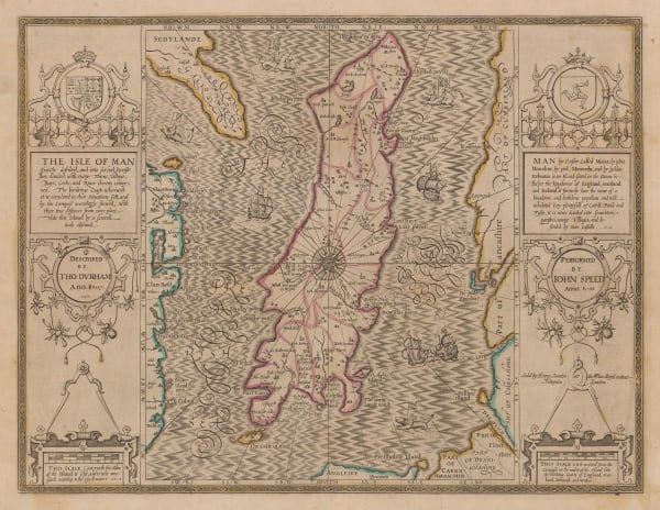
John Speed, The Isle of Man, 1743£ 1,450.00
-
Elias Baeck, The Kingdoms of England, Scotland & Ireland, 1748£ 395.00
-
Georges-Louis Le Rouge, The British Isles, 1748 c.£ 265.00
-
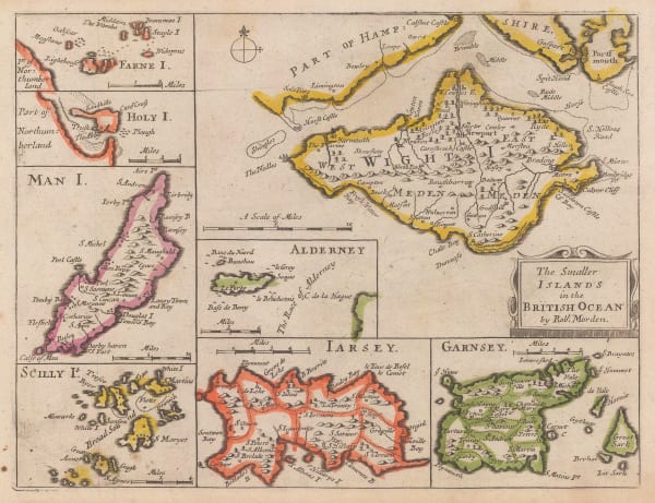
Robert Morden, The Smaller Islands in the British Ocean, 1753£ 345.00
-
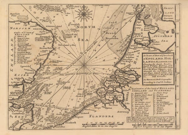
Herman Moll, A Chart of Part of ye Sea Coast of England, Holland & Flanders, 1755 c.£ 195.00
-
Jean de Beaurain, French sea chart of the Channel Islands, 1757£ 2,250.00
-
Jean de Beaurain, Chart of Jersey, 1757£ 2,850.00
-
Jacques-Nicolas Bellin, Carte des Entrees de la Tamise, 1759£ 625.00
-
Gerard van Keulen, A New - Enereasing Compass Map of Part of the East-Coast of England; extending from Eckles to Flamborough-Head; containing the River of Hull; with their Shallow nesses and depths by Claas de Vries Geometra, 1760 c.£ 485.00
-
Gerard van Keulen, De Reede van Harwich, Handford - Water en Wood Bridg Haaven, 1760 c.£ 565.00
-
Johannes [II] van Keulen, Nieuwe Paskaert Van d'Ooft Kust van Engelandt, 1760 c.£ 825.00
-
Gerard van Keulen, [River Thames][Suffolk Coastline], 1760 c.£ 765.00
-
Jacques-Nicolas Bellin, The British Isles, 1764£ 195.00
-
Jacques-Nicolas Bellin, Essex, Kent & the Mouth of the Thames, 1764£ 165.00
-
Étienne André Philippe de Prétot, The British Isles, 1767£ 450.00
-
Russell & Price, The Isle of Man, 1769£ 145.00
-
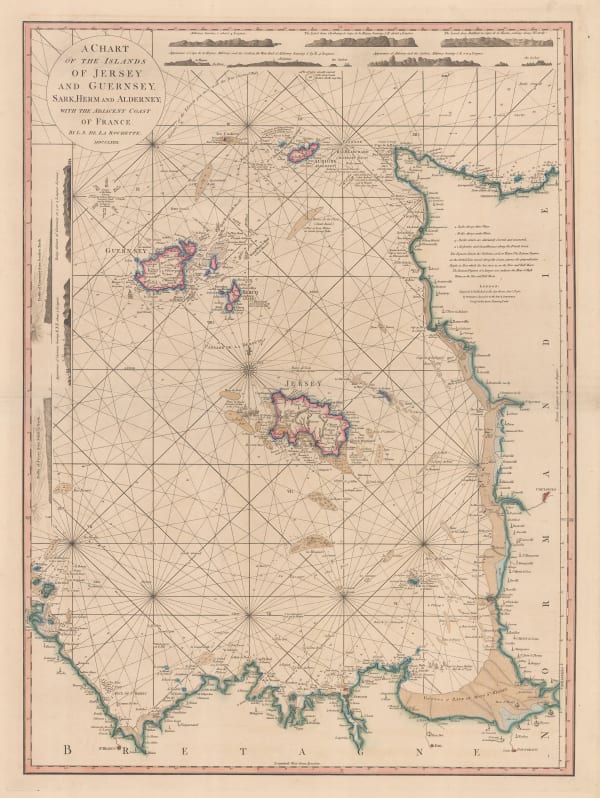
William Faden, Chart of the Channel Islands, 1781£ 2,250.00
-
Capt. Greenvile Collins, [North Sea & East Coast of England], 1785£ 785.00
-
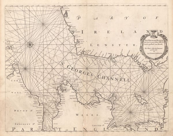
Capt. Greenvile Collins, St. George's Channel, 1785£ 445.00
-
Capt. Greenvile Collins, [The North Sea], 1785£ 745.00
-
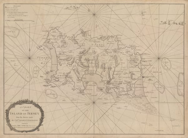
Robert Sayer, A Chart of the Island of Jersey, 1786£ 1,850.00
-
Robert Sayer, A New Hydrographic Sketch of the North, South and Middle Channels, 1786£ 495.00
-
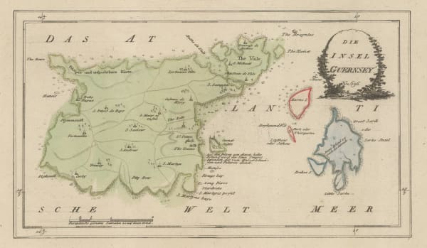
Franz Von Reilly, Guernsey, 1790 c.£ 345.00
-
William Faden, The North Sea with the Kattegat, 1796£ 1,450.00
-
Laurie & Whittle, A New Chart of the British Channel, 1800£ 1,750.00
-
William Heather, Plymouth Sound, Portland and Falmouth & Helford, 1800 c.£ 950.00
-
William Heather, The Entrances to the River Thames, 1801£ 1,650.00
-
William Heather, Chart of the East Coast of England, 1802£ 950.00
-
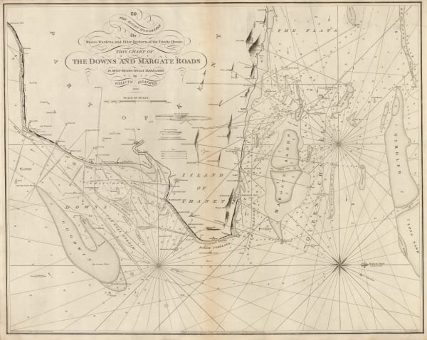
William Heather, The Downs and Margate Roads, 1802£ 750.00
-
William Heather, A New Chart of the Bristol Channel, 1803£ 1,450.00
-
William Heather, Sea Chart of the British Isles, 1804£ 1,850.00
-
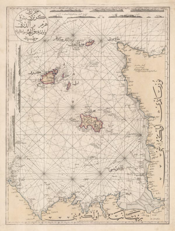
Mahmoud Raif Efendi, Rare Ottoman Map of the Channel Islands, 1804£ 2,200.00
-
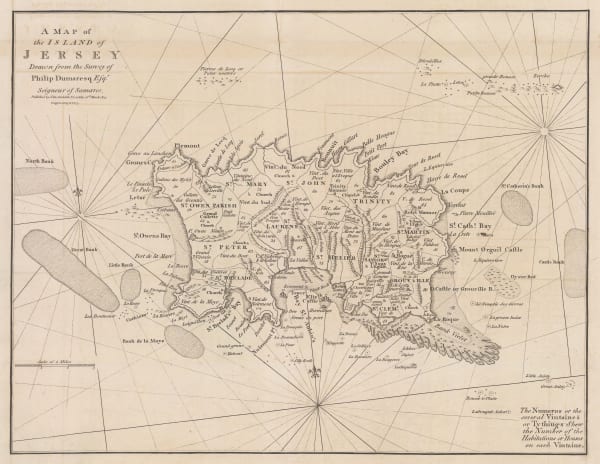
John Cary, A Map of the Island of Jersey, 1805£ 395.00


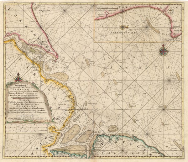

![Johannes [II] van Keulen, Nieuwe Paskaert Van d'Ooft Kust van Engelandt, 1760 c.](https://artlogic-res.cloudinary.com/w_600,c_limit,f_auto,fl_lossy,q_auto/artlogicstorage/themaphouse/images/view/b85698e11ad3b355a2ff9937c6dc3befj/themaphouse-johannes-ii-van-keulen-nieuwe-paskaert-van-d-ooft-kust-van-engelandt-1760-c..jpg)
![Gerard van Keulen, [River Thames][Suffolk Coastline], 1760 c.](https://artlogic-res.cloudinary.com/w_600,c_limit,f_auto,fl_lossy,q_auto/artlogicstorage/themaphouse/images/view/a7825455b2b140129b1f50ed7b79ffc6j/themaphouse-gerard-van-keulen-river-thames-suffolk-coastline-1760-c..jpg)


![Capt. Greenvile Collins, [North Sea & East Coast of England], 1785](https://artlogic-res.cloudinary.com/w_600,c_limit,f_auto,fl_lossy,q_auto/artlogicstorage/themaphouse/images/view/55f0a75a81ef615a6ebefa7947734800j/themaphouse-capt.-greenvile-collins-north-sea-east-coast-of-england-1785.jpg)
![Capt. Greenvile Collins, [The North Sea], 1785](https://artlogic-res.cloudinary.com/w_600,c_limit,f_auto,fl_lossy,q_auto/artlogicstorage/themaphouse/images/view/db4a463c01a4ebeb9f3eb03b21bc6614j/themaphouse-capt.-greenvile-collins-the-north-sea-1785.jpg)


Page
1
of 3