-
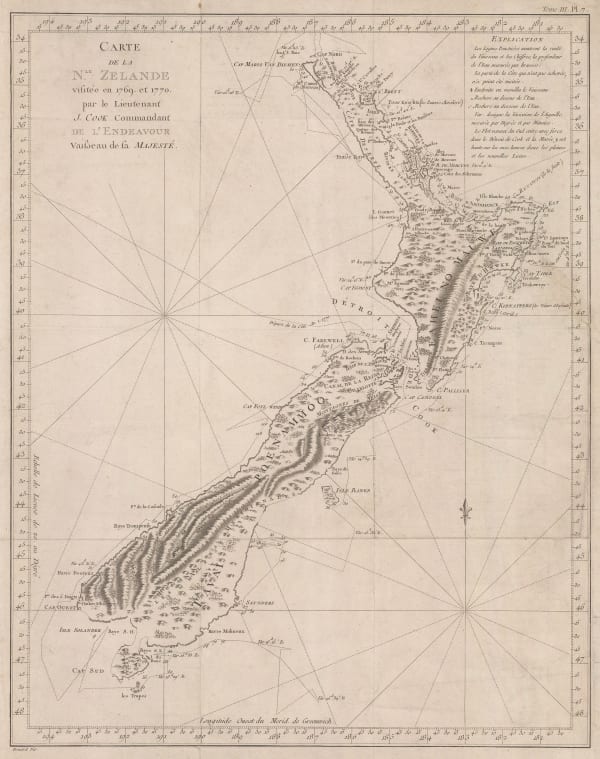
 Capt. James Cook, New Zealand, 1774£ 3,750.00
 -
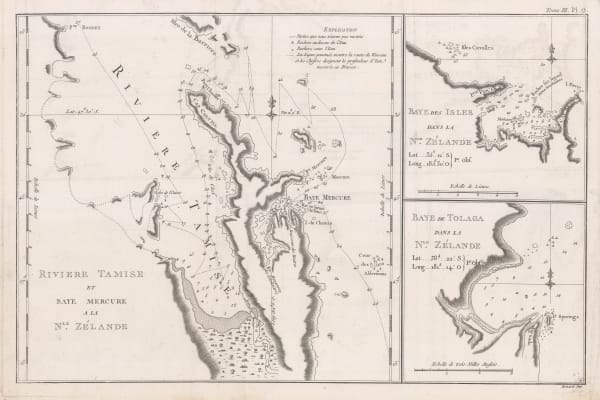
Capt. James Cook, River Thames and Mercury Bay | Bay of Islands | Tolaga Bay in New Zealand, 1774£ 625.00
-
Antonio Zatta, La Nuova Zelanda, 1778£ 3,450.00
-
Capt. James Cook, Schets van de DonkereBaai in Nieuw Zeeland, 1794£ 295.00
-
Philippe Vandermaelen, Océanique Partie de la Nlle Zélande. No. 60, 1827£ 1,475.00
-
W. & A.K. Johnston, New Zealand, 1850 c.£ 1,250.00
-
Royal Geographical Society (RGS), The Middle Island, 1851£ 245.00
-
Royal Geographical Society (RGS), The Middle Island (New Zealand), 1851£ 295.00
-
A. & C. Black, New Zealand, 1854£ 245.00
-
George Philip & Son Ltd., New Zealand, 1854£ 295.00
-
Royal Geographical Society (RGS), Map of the Provinces of Canterbury and Otago, 1864£ 325.00
-
Royal Geographical Society (RGS), Map of the Province of Canterbury (New Zealand), 1867£ 175.00
-
John Bartholomew, New Zealand, 1868£ 95.00
-
Walter Blackie, New Zealand, 1870 c£ 295.00
-
Society for the Diffusion of Useful Knowledge (SDUK), The Islands of New Zealand, 1875£ 625.00
-
William Collins, New Zealand, 1880 (c.)£ 85.00
-
W. & A.K. Johnston, New Zealand, 1880 (c.)£ 62.00
-
Edward Stanford, New Zealand, 1880 c£ 95.00
-
Letts & Son, New Zealand, 1883£ 295.00
-
Royal Geographical Society (RGS), New Zealand - Outline Map of Southern Part of South Island, 1884£ 165.00
-
Royal Geographical Society (RGS), Map of the King Country and Neighbouring Districts, 1885£ 395.00
-
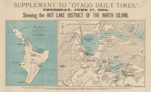
James Alexander Matthews, Hot Lake District of the North Island, 1886£ 145.00
-
Royal Geographical Society (RGS), Tarawera District, New Zealand, 1886£ 110.00
-
A. Simon, Lyttelton, 1889£ 98.00
-
T. Ruddiman Johnston, New Zealand, 1890£ 145.00
-
A. Simon, Nouvelle Zealande. Timaru (1890)., 1890£ 95.00
-
G. & J. Bartholomew, New Zealand: North Island, 1891£ 62.00
-
Royal Geographical Society (RGS), The Central Portion of the Southern Alps of New Zealand, 1893£ 195.00
-
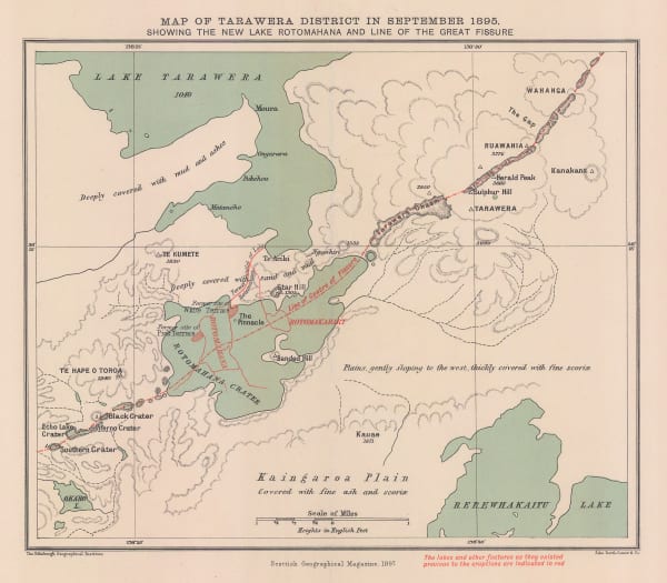
Map of Tarawera District in September 1895, 1897Scottish Geographical Society (SGS)Series: EdinburghScottish Geographical Society (SGS), Map of Tarawera District in September 1895, 1897£ 68.00
-
Scottish Geographical Society (SGS), Map Showing the Volcanic Zone of North Island, N.Z., 1897£ 94.00
-
Edward Stanford, New Zealand, 1904£ 275.00
-
Royal Geographical Society (RGS), The New Zealand Lakes, 1904£ 395.00
-
Colonial Survey, Map of the South Island of New Zealand, 1906£ 295.00
-
E. Baudelot, Auckland, 1911£ 72.00
-
H. Wise & Co., Map of City and Suburbs of Dunedin, 1930 c.£ 695.00
Close
Search Inventory
Our entire inventory of over 10,000 antique and vintage maps is now available to browse by region, date, cartographer, and subject


Join our mailing list
* denotes required fields
We will process the personal data you have supplied to communicate with you in accordance with our Privacy Policy. You can unsubscribe or change your preferences at any time by clicking the link in our emails.
![]()