-
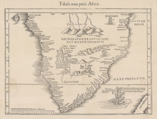
 Martin Waldseemüller & Laurent Fries, The Second Printed Map of Southern Africa, 1541£ 4,950.00
 -
Petrus Bertius, Africae pars meridional., 1618£ 450.00
-
Willem & Jan Blaeu, Southern & Central Africa, 1640 c.£ 1,250.00
-
Nicolas & Guillaume Sanson, Pays, et Coste des Caffres: Empires du Monomotapa Monoemugi, 1656£ 695.00
-
Athanasius Kircher, The Source of the Nile in the Mountains of the Moon, 1665£ 1,750.00
-
Robert Morden, Southern & Central Africa, 1688£ 375.00
-
Pierre Duval, Southern & Central Africa, 1694£ 295.00
-
Pierre Mortier, Carte Particuliere des Costes du Cap de Bone Esperance, 1700£ 2,500.00
-
Nicolas de Fer, Southern & Central Africa, 1702£ 795.00
-
Pieter van der Aa, Le Cap de Bonne Esperance, 1713£ 725.00
-
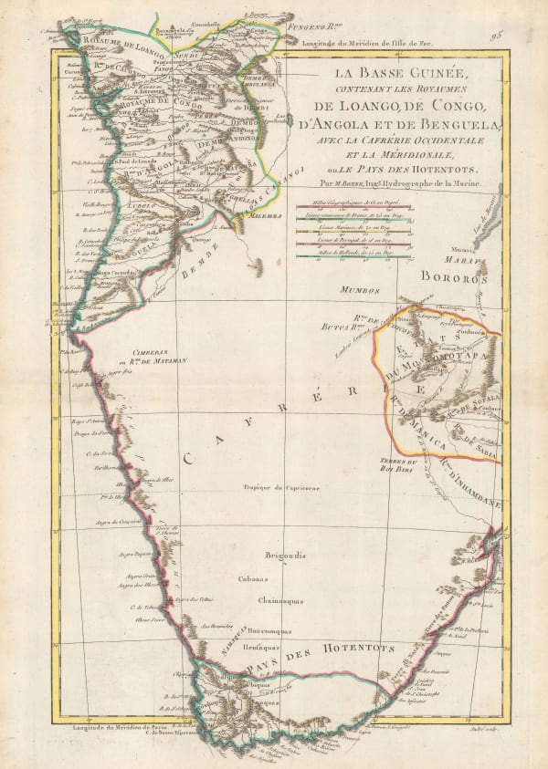
François Valentyn, [Cape Town], 1727£ 950.00
-
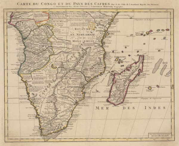
Covens (Jean) & Mortier (Cornelius), Southern & Central Africa, 1730 c.£ 1,250.00
-
Covens (Jean) & Mortier (Cornelius), Le Cap de Bonne Esperance, 1730 c.£ 475.00
-
Jacob van der Schley, Chart of the coast of Angola, Namibia, and South Africa, 1747£ 175.00
-
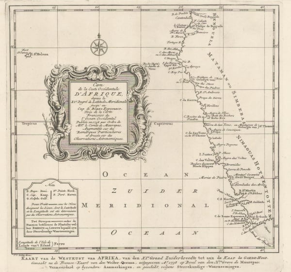
Jacob van der Schley, Carte de la Coste Occidentale D'Afrique depuis le Cap de Bonne Esperance, 1747£ 175.00
-
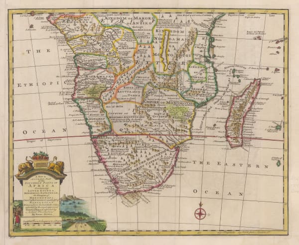
Emanuel Bowen, A New & Accurate Map of the Southern Parts of Africa, 1747£ 695.00
-
Jacques-Nicolas Bellin, Carte de la Baye de la Table, 1750 c.£ 245.00
-
Jacques-Nicolas Bellin, La Pays des Hottentots, 1750 c.£ 275.00
-
Herman Moll, Southern & Central Africa, 1755 c.£ 345.00
-
Thomas Salmon, A Map of the Country of Hottentots towards the Cape of Good Hope, 1759£ 395.00
-
Jacques-Nicolas Bellin, Plan du Fort et de la Ville du Cap de Bonne Esperance, 1760 c.£ 325.00
-
Tobias Conrad Lotter, Southern Africa & the Cape of Good Hope, 1778£ 745.00
-
John Bew, A Map and Chart of the Cape of Good Hope, with the Soundings in Table Bay, False Bay & Saldaniia Bay, 1781£ 595.00
-
Dr. Andreas Sparman, De Kaap de Goede Hoop, 1787 c.£ 565.00
-
Rigobert Bonne, Southern Africa, 1790 c.£ 150.00
-
Laurie & Whittle, A New Chart of the Southern Coast of Africa, 1794£ 3,250.00
-
Laurie & Whittle, A Plan of Table Bay with the Road of the Cape of Good Hope, 1794£ 2,950.00
-
Charles Francois Delamarche, Southern & Central Africa, 1795£ 325.00
-
William Faden, The Dutch Colony of the Cape of Good Hope, 1795£ 1,550.00
-
Francois Levaillant, Carte de la Partie Meridionale de L'Afrique, 1796£ 3,450.00
-
Laurie & Whittle, A Hydrographic Survey of False Bay or Bay False, 1798£ 1,650.00
-
Geographisches Institut Weimar, Charte Von de Halbinsel, 1804£ 595.00
-
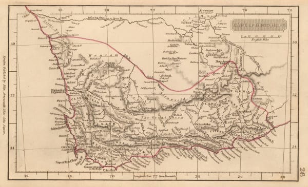
Aaron Arrowsmith, Cape of Good Hope, 1807£ 225.00
-
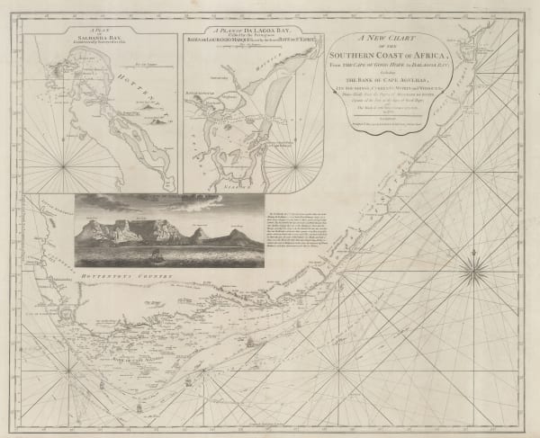
Capt. James Horsburgh, [Southern Africa], 1812£ 785.00
-
John Thomson, South Africa, 1815£ 150.00
-
Philippe Vandermaelen, Colonie du Cap de Bonne Esperance, 1827£ 1,100.00
-
George Thomson, George Thomson's Plan of Cape Town and Environs, 1827£ 750.00
-
Charles Smith, South & Central Africa, 1828£ 285.00
-
Adrien Brue, Southern Africa & the Cape Colony, 1828 c.£ 250.00
-
Thomas Starling, Southern Africa, 1830£ 165.00
-
Royal Geographical Society (RGS), Outline Map of Southern Africa, 1833£ 82.00
-
Royal Geographical Society (RGS), Sketch of South Africa, 1833 c.£ 55.00
-
James Wyld, Cape District Cape of Good Hope, 1838£ 1,150.00
-
Royal Geographical Society (RGS), Capt. Alexander's Route in South Africa, 1838£ 425.00
-
John Arrowsmith, Cape of Good Hope, 1842£ 850.00
-
John Arrowsmith, Cape of Good Hope, 1842£ 68.00
-
Joseph Meyer, Neueste Karte von Sudafrica, 1846£ 225.00
-
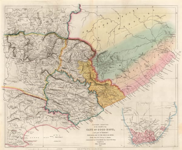
John Arrowsmith, Eastern Frontier of the Colony of the Cape of Good Hope, 1847£ 495.00
-
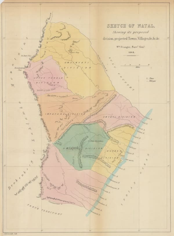
John Arrowsmith, Sketch of Natal, 1848£ 225.00
-
James Wyld, South Africa, 1850 c.£ 1,275.00
-
John Tallis, Natal and Kaffraria, 1851£ 325.00
-
John Tallis, Cape Colony, 1851£ 395.00
-
French Admiralty, Ocean atlantique - Cotes D'Afrique - False Bay, 1852£ 475.00
-
Royal Geographical Society (RGS), South Africa, 1858£ 145.00
-
Royal Geographical Society (RGS), Sketch to Accompany a Trading Trip into the Orange River Free States, 1859£ 92.00
-
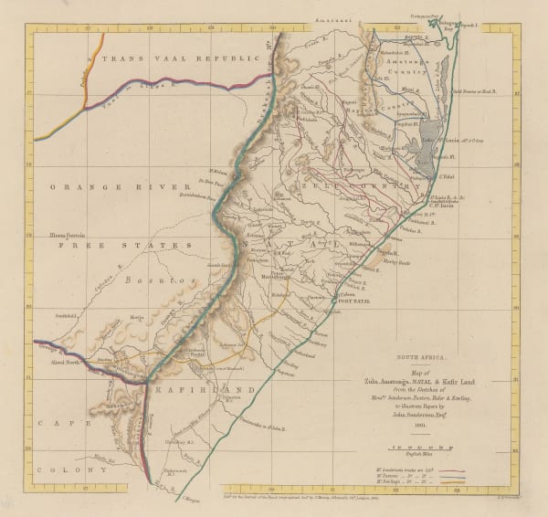
Royal Geographical Society (RGS), South Africa - Map of Zulu, Amatonga, Natal & Kafir Land, 1862£ 115.00
-
Justus Perthes, Ubersicht der Trigonometrischen & Nautischen Aufnahmen im Kaplande, 1863£ 145.00
-
Royal Geographical Society (RGS), Chart of the Currents Off the Cape of Good Hope, 1865£ 345.00
-
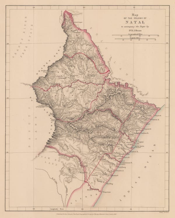
Royal Geographical Society (RGS), Map of the Colony of Natal, 1867£ 85.00
-
James Imray, The Coast of the Cape Colony, 1868£ 2,250.00
-
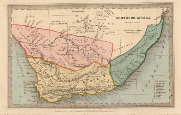
Justus Perthes, [Southern Africa], 1869£ 75.00
-
Justus Perthes, Originalkarte von C.Mauch's Reisen im Innern von Sud-Afrika, 1870£ 345.00
-
Royal Geographical Society (RGS), Sketch Map of Mr. Baines' Routes Between the Limpopo and Zambesi Rivers, 1871£ 150.00
-
Gustav Arthur Troye, The Johannesburg Gold Rush, 1871£ 750.00
-
Royal Geographical Society (RGS), A Sketch map of Part of South Eastern Africa to Illustrate the Journeys of Dr Lacerda (1798) the Pombeiros (1806-11) and Major Monteiro (1831-32), 1873£ 395.00
-
Society for the Diffusion of Useful Knowledge (SDUK), South Africa, 1875£ 345.00
-
Royal Geographical Society (RGS), Map of the Transvaal and the Surrounding Territories, 1877£ 495.00
-
-
Royal Geographical Society (RGS), Map of the Central Portion of South Africa Illustrating Dr. Holub's Journeys 1873-9, 1880£ 165.00
-
Frederick Dangerfield & Co., Natal, 1880 c.£ 575.00
-
Justus Perthes, Karte der Witwatersrand Goldfelder, 1888£ 58.00
-
Royal Geographical Society (RGS), The Kaap Goldfields, 1888£ 112.00
-
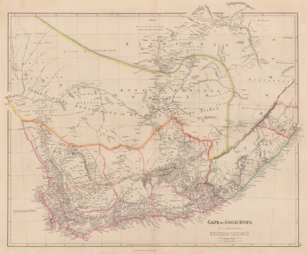
Arbuckle Brothers Company, [Cape Colony], 1889£ 165.00
-
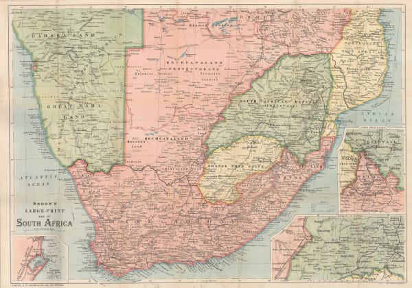
George W. Bacon, Bacon's Large-Print Map of South Africa, 1890 c.£ 775.00
-
Royal Geographical Society (RGS), A Map of Matabililand and Mashonaland Manica and Gazaland, 1891£ 395.00
-
Royal Geographical Society (RGS), Map of the Zoutpansberg Goldfields, 1893£ 275.00
-
Edward Stanford, The Boer Republics, 1899£ 385.00
-
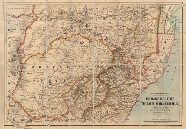
Edward Stanford, The Orange Free State and the Southern Part of The South African Republic, 1899£ 845.00
-
W. & A.K. Johnston, W & A.K. Johnstons Map to Illustrate the Transvaal Question, 1899£ 445.00
-
F Bianconi, Nouvelle Carte Physique & Miniere du Transvaal, 1900£ 495.00


![François Valentyn, [Cape Town], 1727](https://artlogic-res.cloudinary.com/w_600,c_limit,f_auto,fl_lossy,q_auto/artlogicstorage/themaphouse/images/view/8ca7dbc78f3390c704ced1cad0a30728j/themaphouse-fran-ois-valentyn-cape-town-1727.jpg)


![Capt. James Horsburgh, [Southern Africa], 1812](https://artlogic-res.cloudinary.com/w_600,c_limit,f_auto,fl_lossy,q_auto/artlogicstorage/themaphouse/images/view/048123f3e3949fb5f6929700581858d1j/themaphouse-capt.-james-horsburgh-southern-africa-1812.jpg)


![Justus Perthes, [Southern Africa], 1869](https://artlogic-res.cloudinary.com/w_600,c_limit,f_auto,fl_lossy,q_auto/artlogicstorage/themaphouse/images/view/3da3fe1a7118fb5c4b4871d473f09ba5j/themaphouse-justus-perthes-southern-africa-1869.jpg)


![Arbuckle Brothers Company, [Cape Colony], 1889](https://artlogic-res.cloudinary.com/w_600,c_limit,f_auto,fl_lossy,q_auto/artlogicstorage/themaphouse/images/view/0973ff6e6f03fdadda4660911d8ea4d0j/themaphouse-arbuckle-brothers-company-cape-colony-1889.jpg)


Page
1
of 2