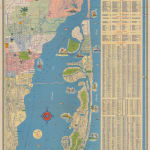
Rand, McNally & Co.
81 x 45 cm
1. The former Orange Bowl is still officially named Burdine Stadium, though 'Orange Bowl' is given as an unofficial moniker, suggesting that at least the first Orange Bowl game had been played. The stadium was built in 1937 and the first Orange Bowl game was played in 1938. The stadium was not officially renamed until 1949.
2. Miami International Airport is still named the '36th Street Airport' and covers only a small portion of the airport's current footprint. Pan-American expanded the airport in 1942 with the purchase of an additional 114 acres of land.
3. The Morningside neighbourhood of North Miami is still largely unbuilt. This development happened quite rapidly between 1936 and 1942.
4. None of the wartime seaplane bases are marked on the map, which suggests a date before December 1941.
5. The University of Miami's campus is labelled as the 'Future Site' of the University. This is an odd feature given that the University had a presence in Coral Gables from 1926. However, much of the development of the campus only occurred after the Great Depression in the early 1940s. On a later edition of this map from 1947, the campus is correctly marked.
The map is embellished throughout by decorative cartoons showing Miami natives enjoying activities, such as sailing, fishing, and golfing. Advertisements on the back of the map promote Gulf Oil products and gas stations.
Printed colour. [USA9581]


