J.P. Sayer
20 x 26 cm
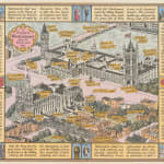
Charming pictorial map of the Palace of Westminster, Westminster Abbey and Westminster School with names of their individual buildings and spaces and notes about historical figures and events. Surrounding text detailing the history of the Palace of Westminster, with note to the oak hammer-beam roof of Westminster Hall, the Houses of Parliament and 'Big Ben', the Abbey and the School.
On the reverse, a map of 'Old Westminster' showing the area as in 1750.
This map is one a of a series of maps of London neighbourhoods, designed by J.P. Sayer and published monthly in the Strand Magazine from 1946-48. The maps are playful and accessible to an ordinary reader, but also contain a surprising amount of history and detail to explore.
Printed colour. [LDN7040]


