James Wyld
77 x 108 cm
The world’s first underground passenger railway opened in London in January 1863. Devised as a way to reduce road traffic by connecting London’s northern mainline railway stations (Paddington, King’s Cross, and Euston) to the City’s financial centre, the Metropolitan Railway initially ran from Paddington to Farringdon, a distance of just under 4 miles. Despite the uncomfortable conditions resulting from soot, smoke, and darkness, over 9 million passengers travelled along this route within the first year, making it an enormous success.
The Metropolitan Railway’s initial triumph led to a rush of applications to Parliament for new railway lines connecting London’s other mainline railway stations. Wary of the negative effects of further encroachment by railways on the city, a House of Lords select committee was established to investigate the various proposals and to develop a coherent scheme which would protect the fabric of the city. Their recommendation, was to construct an “inner circuit of railway that should abut, if not actually join, nearly all of the principal railway termini in the Metropolis”. Submitted proposals to extend the Metropolitan Line in a circular fashion were given Royal Assent, and a new company, the Metropolitan District Railway (commonly known as the District Railway), was formed to complete the southern half of the loop.
By the end of 1863, several of London’s leading cartographers (James Wyld, Edward Stanford, and George Bacon, amongst others), sensing a commercial opportunity, had published detailed folding maps illustrating the railway proposals before the Select Committee. These are some of the earliest maps of London to note the completed Metropolitan Line and to signal the advent of the London Underground network.
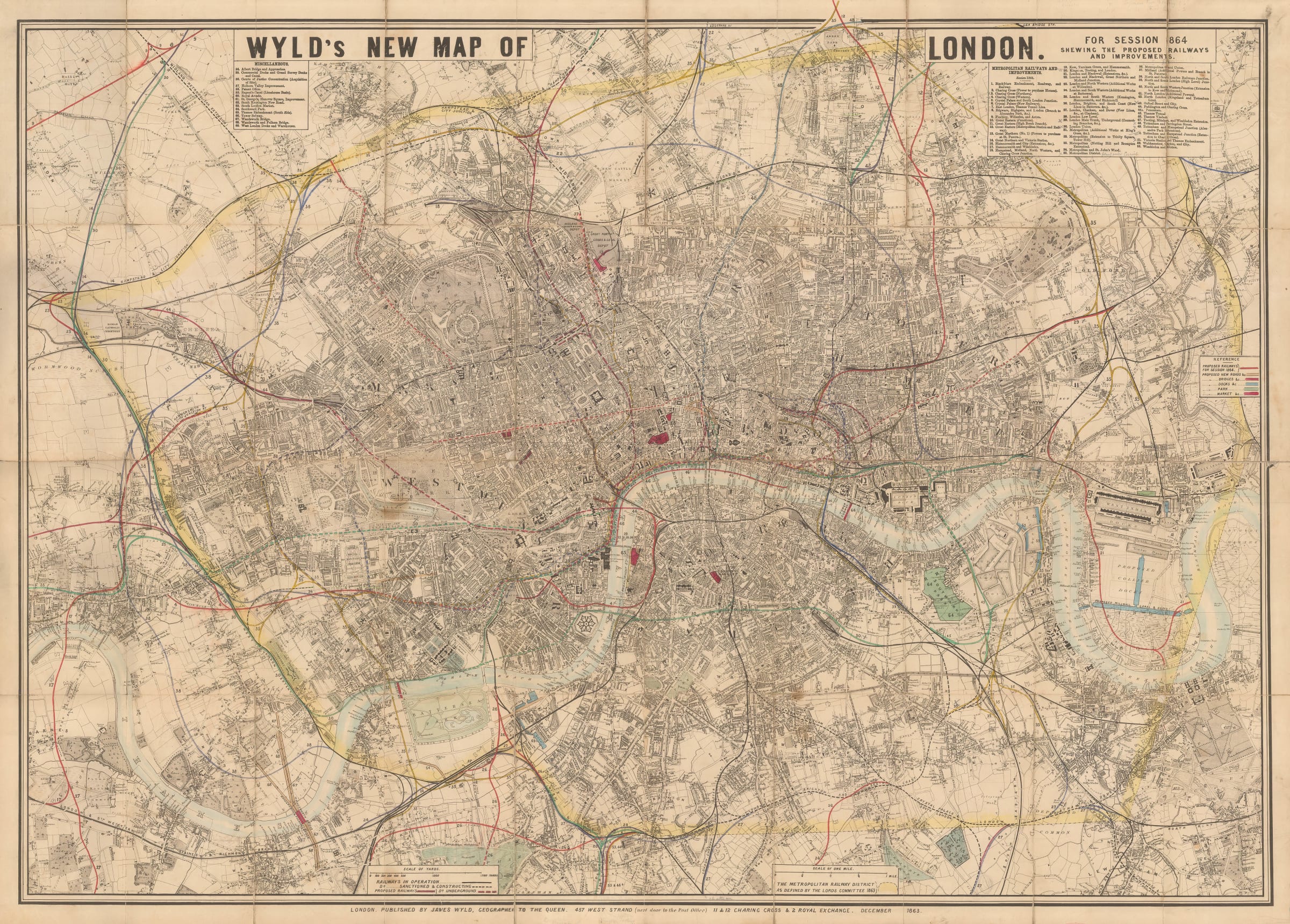
The style of the map is crude and hurried, with little attention given to aesthetic. Wyld has employed an earlier map of London as a base layer, removing extraneous decoration and adding railway lines in colour. Many of the indexes and lists are askew, whilst the title and the publisher’s imprint look like they were added by hand, almost as an afterthought. This is unsurprising given that over 250 separate railway schemes were brought before the committee in 1864, totalling over 300 miles of track. It is likely that Wyld has filtered these proposals to eliminate duplicate suggestions or remove any which were unlikely to succeed.
The map focuses on Central London from Hammersmith to Greenwich, and from Hampstead to Clapham. The area outlined with yellow shading represents the “Metropolitan Railway District”, or the area under the Select Committee’s planning control, as defined by the Lords Committee in 1863.
Railways proposed to the committee for discussion in 1864 are drawn with red lines. Dashed red lines represent proposed underground railways. Similarly, railways already in operation are marked with black lines, whilst dashed black lines represent those which have been approved and are under construction. Sixty-nine separate improvements are listed in two indexes in the top-right and top-left corners of the map. The majority of these are railways, but several other great works of the Victorian Era are included, such as Isambard Brunel’s Thames Tunnel, Limehouse Basin, Albert Bridge, Southwark Park, and Wandsworth Bridge. Distinct colours are used on the map to note proposed bridges, roads, parks, and markets.
Printed colour. Folded. [LDN6050]