Nicolas Visscher
Map of the World, 1680 c
12 x 18 ½ in
30 x 47 cm
30 x 47 cm
WLD4744
Orbis Terrarum Tabula Recens Emendata et in Lucem Edita Double hemisphere map of the world by Nicholas Visscher published for a Bible. The illustrated borders are allegories of the four...
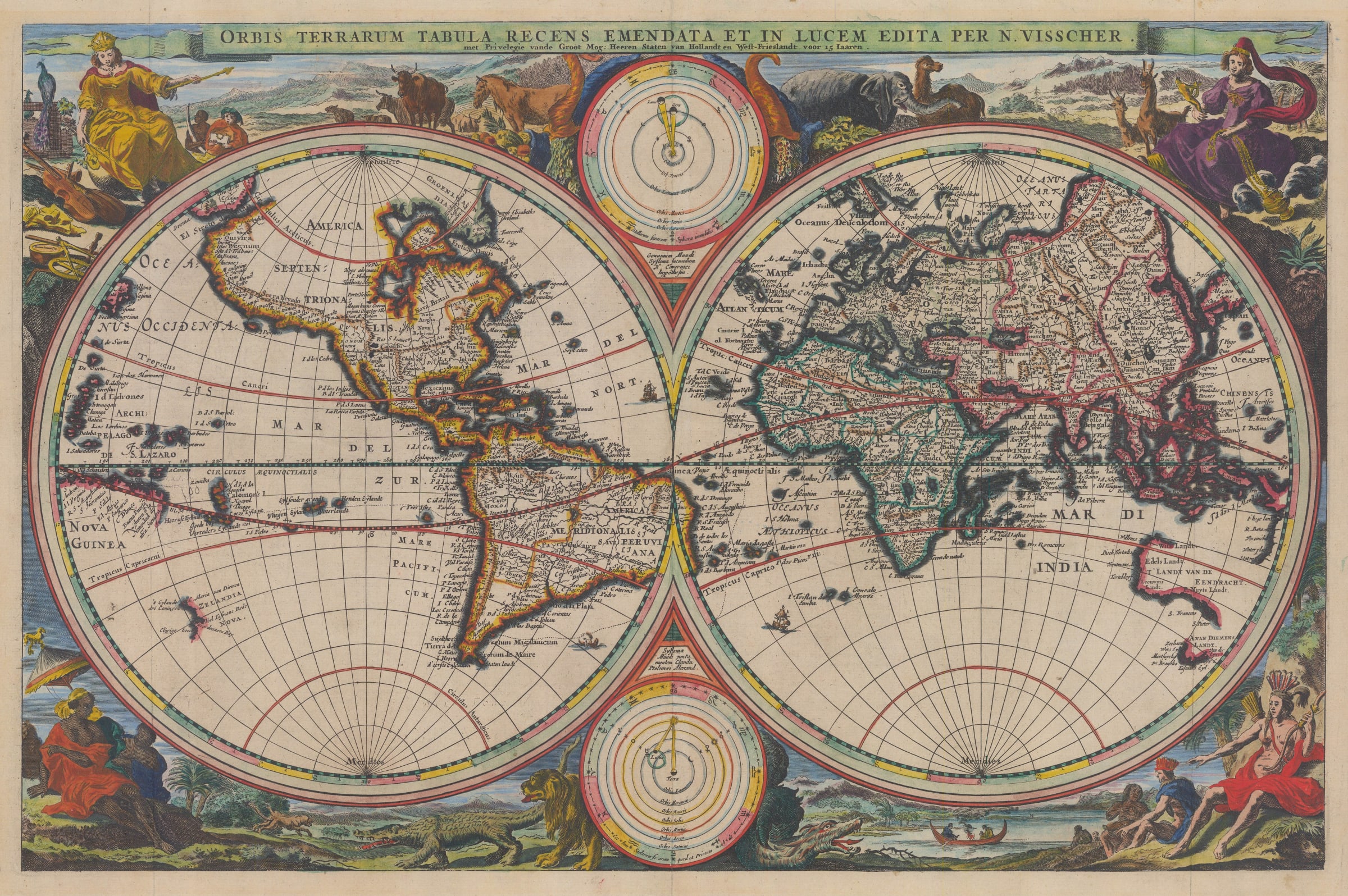
Orbis Terrarum Tabula Recens Emendata et in Lucem Edita
Double hemisphere map of the world by Nicholas Visscher published for a Bible. The illustrated borders are allegories of the four continents.
From 1657 onwards, Nicolas Visscher issued a series of maps commissioned by Dutch Bible publishers. Usually, the maps were of the Biblical world focusing on the Middle East, the Holy Land, Jerusalem and often a specific Biblical event such as tracking the Exodus or a map of the Mediterranean showing the travels of St. Paul. Almost always, a double hemisphere map of the world was present current to the time of publishing. Visscher was the first cartographer to issue these maps but the concept rapidly became popular and the maps soon gained many emulators.
This example is the second map which Visscher first prepared for a Bible in 1663. Now reduced in size, the geography is based on Visscher’s earlier map of 1657. That map in turn was based on a compilation of Jodocus Hondius II who in 1625, published a map with an extension of the Pacific Northwest coast of North America, leading to a possible Northwest Passage. The information about Australia is far more recent. It first appeared on a wall map by Joan Blaeu in 1648. It was based on the accounts of the explorer, Abel Tasman. This version of Australia is based on Tasman’s first voyage exploring the west and south of the continent as well as a small stretch of the coast of New Zealand. A year later, Visscher would go onto publish a map incorporating the information from both of Tasman’s voyages. California is firmly a peninsula, against the orthodox belief of the time. The information on the Far East is very much based on early 17th century thought, particularly in the portrayal of Korea as an island, a very narrow China and the Dutch East Indies based on the Hondius map of the region first issued in 1606.
The sumptuous decorations, again based on the Visscher map of 1657 and so typical of the Dutch Golden Age, are allegorical figures representing the four named continents of the 17th century.
This example of the map is the second state, with a note under the title granting a privilege of 15 years, making its publication date after 1677.
Dutch text on reverse. Image available on request. Coloured. [WLD4744] [Shirley 431, State 2]