James Gardner
Cotswolds - Chipping Norton, Banbury & Deddington, 1833 c.
13 x 16 ½ in
33 x 42 cm
33 x 42 cm
OXON559
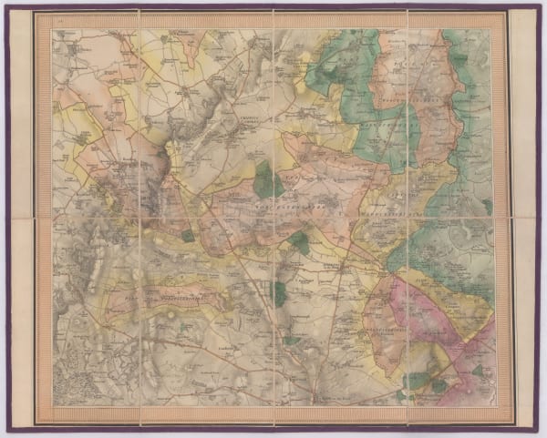
A folding example of the first edition O.S. map of the area surrounding Chipping Norton, Banbury, and Deddington on the eastern edge of the Cotswolds. Virtually every building, farm, wood,...
A folding example of the first edition O.S. map of the area surrounding Chipping Norton, Banbury, and Deddington on the eastern edge of the Cotswolds. Virtually every building, farm, wood, estate, road, and track is marked on the map, a testament to the exceptional work of the Ordnance Survey's early surveyors.
Known as the 'Old Series', the first edition of the Ordnance Survey's One-Inch maps of England and Wales were published between 1805 and 1869. This map is the northwest quarter of Sheet 45 of the One-Inch Series (after 1833 the larger O.S. map sheets were broken down into quarters for commercial sale). The map bears the imprint of James Gardner, a London engraver and map seller who was awarded the title of sole commercial agent for the Ordnance Survey from 1823 until his retirement around 1840.
Original hand-colour. [OXON559]
Related artworks
-
 James Gardner, Cotswolds - Charlbury, Woodstock & Blenheim, 1833 c.Reserved
 -
James Gardner, Cotswolds - Moreton-in-Marsh, Chipping Campden & Stow-on-the-Wold, 1833 c.Reserved
-
James Gardner, First Edition O.S. Map of Bicester and Environs, 1833 c.£ 195.00
-
James Gardner, Cotswolds - Burford, Northleach & Bourton, 1833 c.Reserved