-

-
Emanuel Bowen & Thomas Kitchin, A New and Accurate Map of Warwickshire, 1760£ 850.00
-
Emanuel Bowen, A New Map of the Counties of Cumberland and Westmoreland, 1760£ 695.00
-
Emanuel Bowen, An Accurate Map of Cambridgeshire Divided into its Hundreds, 1760£ 625.00
-
An Accurate Map of Nottinghamshire Describing its Wapontakes and Divisions, 1760Emanuel Bowen & Thomas KitchinSeries: LondonEmanuel Bowen & Thomas Kitchin, An Accurate Map of Nottinghamshire Describing its Wapontakes and Divisions, 1760£ 395.00
-
Emanuel Bowen, A New Improved Map of Cornwall, 1760 c£ 2,200.00
-
Emanuel Bowen, An Accurate Map of the East Riding of Yorkshire, 1760 c£ 1,150.00
-
Emanuel Bowen, An Improved Map of Wiltshire Divided into its Hundreds, 1760 c£ 1,150.00
-
Richard William Seale, Map of the County of Middlesex, 1760 c£ 775.00
-
T. & E. Bowen, A Corrected Map of the County of Stafford Divided into Hundreds, 1760 c.£ 475.00
-
Emanuel Bowen & Thomas Kitchin, A New Improved Map of Hampshire, 1760 c.£ 1,750.00
-
A New Improved Map of Hartfordshire from the Best Surveys & Intelligence Divided into its Hundreds, 1760 c.Thomas KitchinSeries: LondonThomas Kitchin, A New Improved Map of Hartfordshire from the Best Surveys & Intelligence Divided into its Hundreds, 1760 c.£ 595.00
-
Emanuel Bowen & Thomas Kitchin, A New Improved Map of Oxfordshire, 1760 c.£ 1,350.00
-
Thomas Kitchin, A New Map of Northamptonshire, 1760 c.£ 98.00
-
Thomas Kitchin, A New Map of Westmoreland, 1760 c.£ 55.00
-
Emanuel Bowen, An Accurate Map of Devon Shire, 1760 c.£ 1,350.00
-
An Accurate Map of Dorset Shire Divided into its Hundreds, 1760 c.Emanuel Bowen & Thomas KitchinSeries: LondonEmanuel Bowen & Thomas Kitchin, An Accurate Map of Dorset Shire Divided into its Hundreds, 1760 c.£ 1,250.00
-
Emanuel Bowen, An Accurate Map of Lincolnshire Divided into its Wapontakes, 1760 c.£ 650.00
-
An Accurate Map of Northamptonshire Divided into its Hundreds, 1760 c.Emanuel Bowen & Thomas KitchinSeries: LondonEmanuel Bowen & Thomas Kitchin, An Accurate Map of Northamptonshire Divided into its Hundreds, 1760 c.£ 550.00
-
Emanuel Bowen, An Accurate Map of the Counties of Gloucester and Monmouth, 1760 c.£ 1,150.00
-
An Accurate Map of the County of Bedford Divided into its Hundreds, 1760 c.Emanuel BowenSeries: LondonEmanuel Bowen, An Accurate Map of the County of Bedford Divided into its Hundreds, 1760 c.£ 650.00
-
Emanuel Bowen, An Accurate Map of the County of Derby, 1760 c.£ 750.00
-
Emanuel Bowen, An Accurate Map of the County of Essex, 1760 c.£ 1,250.00
-
Emanuel Bowen, An Accurate Map of the County of Huntingdon, 1760 c.£ 425.00
-
Emanuel Bowen, An Accurate Map of the County of Kent, 1760 c.£ 1,550.00
-
T. & E. Bowen, An Accurate Map of the County of Norfolk, 1760 c.£ 950.00
-
An Accurate Map of the County of Suffolk Divided into its Hundreds, 1760 c.Emanuel BowenSeries: LondonEmanuel Bowen, An Accurate Map of the County of Suffolk Divided into its Hundreds, 1760 c.£ 1,150.00
-
Emanuel Bowen & Thomas Kitchin, An Accurate Map of the County of York, 1760 c.£ 965.00
-
Emanuel Bowen, An Accurate Map of the County Palatine of Chester, 1760 c.£ 950.00
-
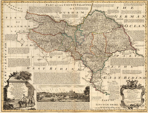
An Accurate Map of the North Riding of York Shire, 1760 c.Emanuel Bowen & Thomas KitchinSeries: LondonEmanuel Bowen & Thomas Kitchin, An Accurate Map of the North Riding of York Shire, 1760 c.£ 1,150.00
-
An Accurate Map of the West Riding of Yorkshire Divided into its Wapontakes, 1760 c.Emanuel BowenSeries: LondonEmanuel Bowen, An Accurate Map of the West Riding of Yorkshire Divided into its Wapontakes, 1760 c.£ 945.00
-
T. & E. Bowen, An Accurate Map of Worcestershire Divided into Hundreds, 1760 c.£ 350.00
-
An Improved Map of the County of Somerset Divided into its Hundreds, 1760 c.Emanuel BowenSeries: LondonEmanuel Bowen, An Improved Map of the County of Somerset Divided into its Hundreds, 1760 c.£ 1,375.00
-
John Speed, Kent, 1760 c.£ 1,650.00
-
Gerard van Keulen, Scarborough & Hartlepool, 1760 c.£ 285.00
-
Gerard van Keulen, [Thanet and the mouth of the River Blakeney], 1760 c.£ 265.00
-
Emanuel Bowen, An Accurate Map of the County of Lancaster, 1760 c.£ 850.00
-
Emanuel Bowen, An Improved Map of the County of Stafford, 1760 c.£ 875.00
-
T. & E. Bowen, An Accurate map of Hereford Shire, 1763£ 545.00
-
T. & E. Bowen, An Accurate Map of the County Palatine of Durham, 1763£ 650.00
-
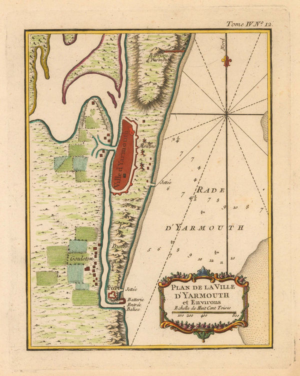
Jacques-Nicolas Bellin, Great Yarmouth, 1764£ 30.00
-
Jacques-Nicolas Bellin, English Channel, 1764£ 245.00
-
Jacques-Nicolas Bellin, Isle of Wight, 1764£ 375.00
-
Jacques-Nicolas Bellin, England and Wales, 1764£ 145.00
-
Jacques-Nicolas Bellin, Plymouth & the Tamar, 1764£ 165.00
-
Jacques-Nicolas Bellin, Portsmouth, 1764£ 125.00
-
Jacques-Nicolas Bellin, Plymouth, 1764£ 185.00
-
Emanuel Bowen, An Accurate Map of Shrop Shire Divided into its Hundreds, 1765 c.£ 745.00
-
Cheshire Drawn from the best Surveys, Maps, Charts, &c and Regulated by Astronomical Observation, 1769Thomas KitchinSeries: LondonThomas Kitchin, Cheshire Drawn from the best Surveys, Maps, Charts, &c and Regulated by Astronomical Observation, 1769£ 84.00
-
Russell & Price, Derby Shire, 1769£ 68.00
-
Russell & Price, Durham, 1769£ 68.00
-
Russell & Price, Hamp-shire, 1769£ 145.00
-
Russell & Price, Hereford Shire, 1769£ 84.00
-
Russell & Price, Lincolnshire, 1769£ 115.00
-
Russell & Price, Middlesex, 1769£ 115.00
-
Russell & Price, Nottingham Shire, 1769£ 62.00
-
Russell & Price, Shropshire, 1769£ 55.00
-
Russell & Price, Stafford Shire, 1769£ 72.00
-
Russell & Price, Suffolk, 1769£ 82.00
-
Russell & Price, Warwick Shire, 1769£ 72.00
-
Russell & Price, Westmorland, 1769£ 62.00
-
Russell & Price, Lancashire, 1769£ 95.00
-
Étienne André Philippe de Prétot, L'Angleterre, 1770£ 295.00
-
Joseph Ellis, A Modern Map of Oxfordshire, 1770 (c.)£ 145.00
-
Thomas Kitchin, An Accurate Map of England and Wales, 1770 c.£ 375.00
-
Thomas Kitchin, Rutlandshire, 1770 c.£ 65.00
-
John Seller, Cheshire, 1774£ 98.00
-
Antonio Zatta, Li Regni d'Inghilterra e d'Irlanda, 1776£ 385.00
-
T. & E. Bowen, An Accurate Map of Cambridge Shire Divided into Hundreds, 1777£ 395.00
-
Emanuel Bowen, An Accurate Map of Derby Shire, 1777£ 485.00
-
Emanuel Bowen, An Accurate Map of Hartford Shire, 1777£ 545.00
-
Emanuel Bowen, An Accurate Map of Lincoln Shire, 1777£ 485.00
-
Emanuel Bowen, An Accurate Map of Nottingham Shire, 1777£ 495.00
-
Emanuel Bowen, An Accurate Map of Somersetshire, Divided into its Hundreds, 1777£ 445.00
-
Emanuel Bowen, An Accurate Map of the County of Bedford, 1777£ 295.00
-
Thomas Kitchin, An Accurate Map of the County of Huntingdon, 1777£ 295.00
-
Emanuel Bowen, An Accurate Map of the County of Lancaster, 1777£ 595.00
-
Emanuel Bowen, An Accurate Map of the County of Surrey, 1777£ 1,450.00
-
Emanuel Bowen, An Accurate Map of the County Palatine of Chester, 1777£ 375.00
-
Emanuel Bowen, An Improved map of the Counties of Cumberland and Westmoreland, 1777£ 475.00


![Gerard van Keulen, [Thanet and the mouth of the River Blakeney], 1760 c.](https://static-assets.artlogic.net/w_600,c_limit,f_auto,fl_lossy,q_auto/artlogicstorage/themaphouse/images/view/6145c3fc2fdd4f8e5a32ae74169abbfdj/themaphouse-gerard-van-keulen-thanet-and-the-mouth-of-the-river-blakeney-1760-c..jpg)


Page
5
of 15