-
 Thomas Bowen, West Indies, 1760 c.£ 345.00
 -
Andrew Dury, A Map of the West India Islands, 1761£ 185.00
-
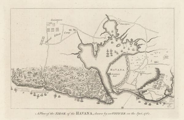
Political Magazine, A Plan of the Siege of the Havana, drawn by an Officer on the spot, 1762., 1762£ 325.00
-
Jacques-Nicolas Bellin, Carte Hydrographique de la Baye de la Havane, 1762£ 1,850.00
-
Jacques-Nicolas Bellin, Carte Reduite de L'Isle de Cube, 1762£ 3,450.00
-
Thomas Jefferys, Plan of the Town and Harbour of San Juan de Puerto Rico, 1762£ 595.00
-
London Magazine, A New Map of the Island of Jamaica Divided into its Parishes, 1763£ 295.00
-
Jacques-Nicolas Bellin, Carte de L'Isle de Sainte Lucie, 1763£ 1,275.00
-
Veremondo Rossi, Nuova e corretta Carta dell Indie Occidentali cavata dalle migliori autorita, 1763£ 685.00
-
Jacques-Nicolas Bellin, Le Port au Prince dans l'Isle de St. Domingue, 1764£ 125.00
-
Jacques-Nicolas Bellin, Plan du Cul de Sac Royal de la Martinique, 1764£ 125.00
-
Jacques-Nicolas Bellin, Port de la Havane dans l'Isle de Cube, 1764£ 365.00
-
Jacques-Nicolas Bellin, Carte de l'Isle de la Grenade, 1764£ 145.00
-
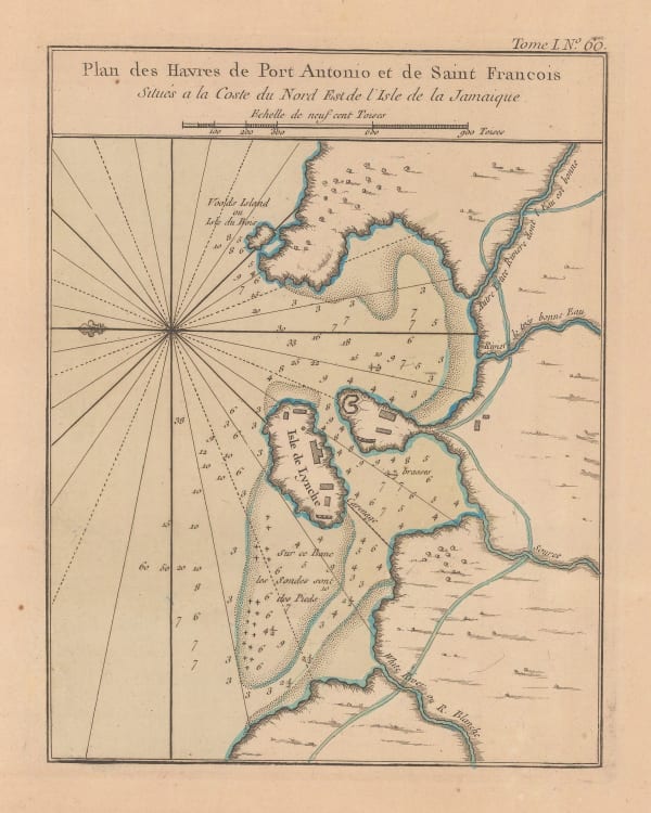
Jacques-Nicolas Bellin, Port Antonio, Jamaica, 1764£ 295.00
-
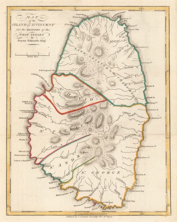
Jacques-Nicolas Bellin, Carte de L'Isle de St. Vincent, 1764£ 225.00
-
Jacques-Nicolas Bellin, Plan du Cul de Sac des Roseaux, 1764£ 145.00
-
Jacques-Nicolas Bellin, Plan du Port du Carenage ou Petit Cul de Sac de L'Isle de Ste. Lucie, 1764£ 145.00
-
Jacques-Nicolas Bellin, Port et Fort Royal de la Grenade, 1764£ 175.00
-
Jacques-Nicolas Bellin, Suite des Isles Antilles 2. Partie, 1764£ 145.00
-
Jacques-Nicolas Bellin, Antigua, 1764£ 275.00
-
Jacques-Nicolas Bellin, Environs du Fort Louis de la Guadeloupe, 1764£ 95.00
-
Jacques-Nicolas Bellin, Marie-Galante, Guadeloupe, 1764£ 125.00
-
Jacques-Nicolas Bellin, Virgin Islands, 1764£ 1,450.00
-
Isaac Tirion, Kaart van de Onderkoningschappen van Mexico en Nieuw Granada in Spaansche West-Indien, 1765£ 595.00
-
Jacques-Nicolas Bellin, Plan de la Cayque de L'Ouest ou la Petite Cayque, 1768£ 295.00
-
Isaac Tirion, De Hoofdstad en Haven, van't Eiland Porto Rico, in de Westindien, 1769£ 525.00
-
Thomas Jefferys, Antigoa, 1769 c.£ 3,500.00
-
Carington Bowles, A New Map of Jamaica, 1771£ 795.00
-
Jacques-Nicolas Bellin, Carte Reduite Du Golphe Du Mexique Et Des Isles De L'Amerique, 1774£ 1,950.00
-
Thomas Jefferys, Dominica from an Actual Survey Compleated in the Year 1773, 1775£ 1,250.00
-
Thomas Jefferys, Guadaloupe, 1775£ 985.00
-
Thomas Jefferys, Martinico, 1775£ 1,150.00
-
Thomas Jefferys, St Vincent from an Actual Survey, 1775£ 1,850.00
-
Thomas Jefferys, St. Lucia; Done from Surveys and Observations made by the English whilst in their Possession, 1775£ 2,450.00
-
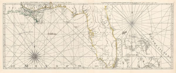
Thomas Jefferys, The Island of Cuba with part of the Bahama Banks & the Martyrs, 1775£ 2,500.00
-
Thomas Jefferys, The Island of Jamaica and Cape Gracias a Dios with the Banks, 1775£ 350.00
-
-
Thomas Jefferys, Turks Islands, 1775£ 1,350.00
-
Thomas Kitchin, Map of the European Settlements in the West Indies, 1776£ 155.00
-
Dr. William Robertson, A Map of the Gulf of Mexico, the islands and Countries Adjacent, 1777£ 595.00
-
Charles Theodore Middleton, The West Indies, 1777£ 225.00
-
Dr. William Robertson, Carte Du Golfe Du Mexique, Des Isles, Et Des Pays Adjacens. Pour l'Histoire de L'Amerique, 1778£ 485.00
-
Georges-Louis Le Rouge, Isle St. Vincent, 1778£ 775.00
-
Antonio Zatta, Le Colonie Unite Dell' America Settentriole di Nuova Projezione Assee Le Signori Riformatori dello Studio de Padova | Le Isole Bermude, 1778£ 2,850.00
-
-
Juan Lopez, Carta de la Isla de la Antigua, 1780£ 885.00
-
John Bew, West Indies with the Harbour and Fort of Omoa, 1780£ 875.00
-
Rigobert Bonne, Carte de L'Isle de la Martinique, 1780 c.£ 185.00
-
Rigobert Bonne, Les Isles Antilles et le Golfe du Mexique, 1780 c.£ 195.00
-
John Hamilton Moore, Plan of the City & Harbour ofHavanna, Capital of Cuba, 1780 c.£ 64.00
-
John Bew, A Map of the English, French, Spanish, Dutch & Danish Islands in the West Indies, 1781£ 225.00
-
Louis Brion de la Tour, Carte des Isles Antilles, 1782£ 1,350.00
-
William Faden, A Chart of the Antilles or Charibbee or Caribs Islands with the Virgin Islands, 1784£ 3,650.00
-
Jacques-Nicolas Bellin, Carte Reduite des Debouquements de St. Domingue, 1787£ 1,275.00
-
Rigobert Bonne, Carte de L'Isle de la Jamaique, 1790 c.£ 92.00
-
Laurie & Whittle, A New and Complete Map of the West Indies: Comprehending all the Coats and Islands Known by That Name, 1794£ 985.00
-
Robert Wilkinson, An Accurate Map of the West Indies, 1794£ 195.00
-
Bryan Edwards, Map of the Island of Dominica for the History of the West Indies, 1794£ 225.00
-
Bryan Edwards, Map of the Island of Grenada, 1794£ 195.00
-
Bryan Edwards, Map of the Island of St. Vincent, 1794£ 225.00
-
Bryan Edwards, Map of the Virgin Islands for The History of the West Indies, 1794£ 895.00
-
William Heather, A New and Improved Chart of the West Indies or Carribbee Islands, 1795£ 1,950.00
-
Franz Ludwig Gussefeld, Charte von West Indien, 1795£ 1,175.00
-
Antonio Zatta, Stabilimenti de Francesi, Inglesi, e Spagnuoli nelle Isole Antille Di nuova Projezione, 1795£ 875.00
-
William Faden, A General Chart of the West India Islands, 1796£ 2,950.00
-
An Accurate Map of the West Indies with the Adjacent Coast of America, 1796John ReidSeries: New YorkJohn Reid, An Accurate Map of the West Indies with the Adjacent Coast of America, 1796£ 495.00
-
Homann Heirs, Karte von Mittle-America oder Westindien, 1796£ 1,350.00
-
Andrew Bell, West Indies, 1797£ 195.00
-
John Stockdale, A Map of the West Indies from the best Authorities, 1799£ 225.00
-
Depot de la Marine, Carte De L'Isle de la Jamaique, 1799£ 725.00
-
John Russell, West Indies, 1799£ 395.00
-
Pierre Tardieu, Carte Du Golfe Du Mexique et Des Isles Antilles, 1800£ 525.00
-
Laurie & Whittle, Plan of the Isle of Trinidad, 1800£ 2,850.00
-
-
Depot de la Marine, Plan du Principal Port de L'ile de Porto Rico, 1802£ 2,450.00
-
John Cary, A New Map of The West India Isles, 1803£ 645.00
-
Mahmoud Raif Efendi, Rare Ottoman Map of the Caribbean, 1804£ 4,450.00
-
-
Joyce Gold, Martinico, 1805£ 48.00
-
Morse and Andrews, West Indies, 1805£ 185.00


Page
2
of 4