-
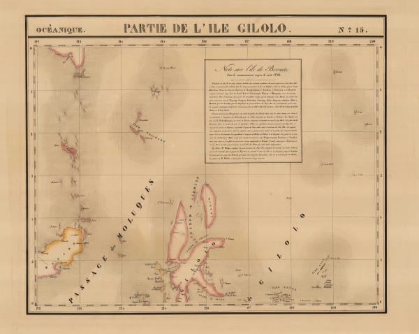
 Philippe Vandermaelen, Sulawesi, North Maluku, 1827£ 195.00
 -
Philippe Vandermaelen, Central and South East Sulawesi, and the Gulf of Tomini, 1827£ 375.00
-
Philippe Vandermaelen, North-western Borneo, 1827£ 325.00
-
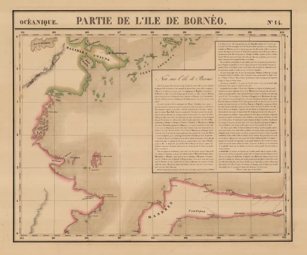
Philippe Vandermaelen, North-eastern Borneo, 1827£ 325.00
-
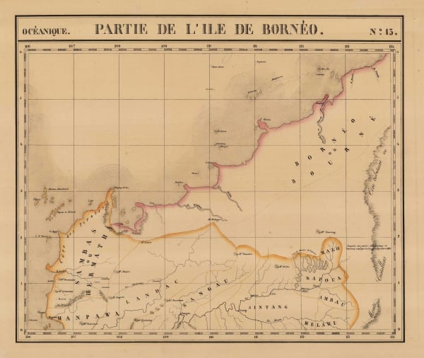
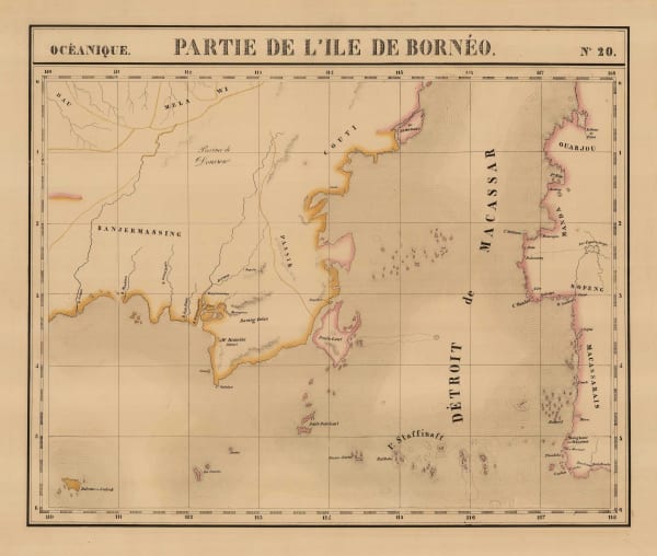
Philippe Vandermaelen, South-eastern Borneo, 1827£ 395.00
-
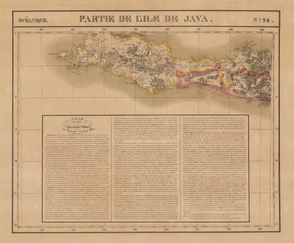
Philippe Vandermaelen, Western Java, 1827£ 285.00
-
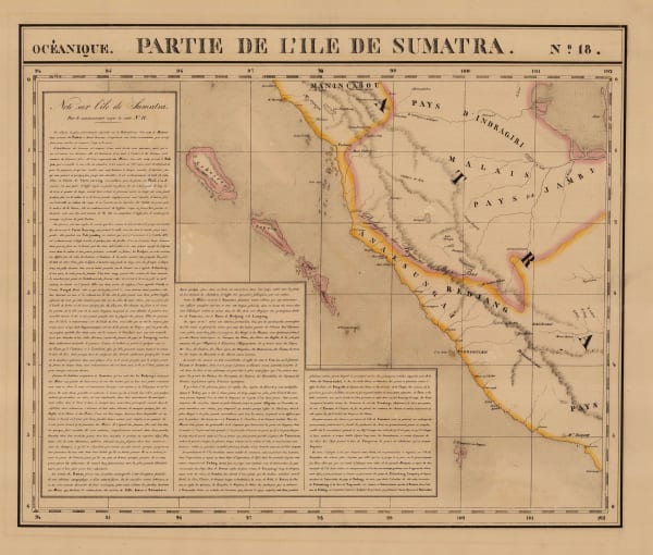
Philippe Vandermaelen, North Sumatra and Aceh, 1827£ 285.00
-
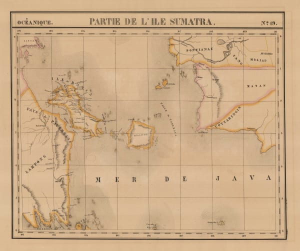
Philippe Vandermaelen, West Sumatra and Riau, 1827£ 185.00
-
Philippe Vandermaelen, South-eastern Sumatra and south-western Borneo, 1827£ 395.00
-
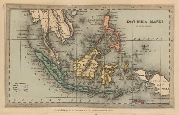
Thomas Starling, Miniature map of Southeast Asia, 1830 c.£ 95.00
-
Rest Fenner, Miniature map of Southeast Asia, 1836£ 85.00
-
W. & A.K. Johnston, First cartographic document to use the name "Malaysia", 1840£ 745.00
-
Joseph Meyer, South East Asia, 1844£ 325.00
-
Archibald Fullarton, Java - according to Van De Velde, 1856£ 76.00
-
Adrian J. Bogaerts, Wall Map of the Dutch East Indies (Indonesia), 1857£ 2,850.00
-
John Dower, East India Isles, 1860 c.£ 195.00
-
Justus Perthes, Northern Borneo, 1861£ 68.00
-
Archibald Fullarton, Java & Borneo, 1862£ 325.00
-
James Imray, East Indian Archipelago. (Eastern passages to China. Chart No. 5), 1863£ 885.00
-
James Imray, East Indian Archipelago. (Eastern Passages to China. Chart No.1), 1863£ 895.00
-
James Imray, East Indian Archipelago. (Eastern Passages to China. Chart No.2), 1863£ 975.00
-
James Imray, East Indian Archipelago. (Western Route to China. Chart No.1), 1863£ 1,250.00
-
Aimé Robiquet, French chart of Indonesia and Malaysia, 1868£ 575.00
-
Joseph Meyer, Southeast Asia showing colonial possessions, 1868£ 245.00
-
Blackie & Son, Sumatra, Borneo, and the Philippines, 1870 c.£ 225.00
-
Justus Perthes, North Maluku, Salawati and Waigeu, Indonesia, 1873£ 125.00
-
John Arrowsmith, Folding map of South East Asia, 1876£ 1,450.00
-
Society for the Diffusion of Useful Knowledge (SDUK), Southeast Asia, 1879£ 385.00
-
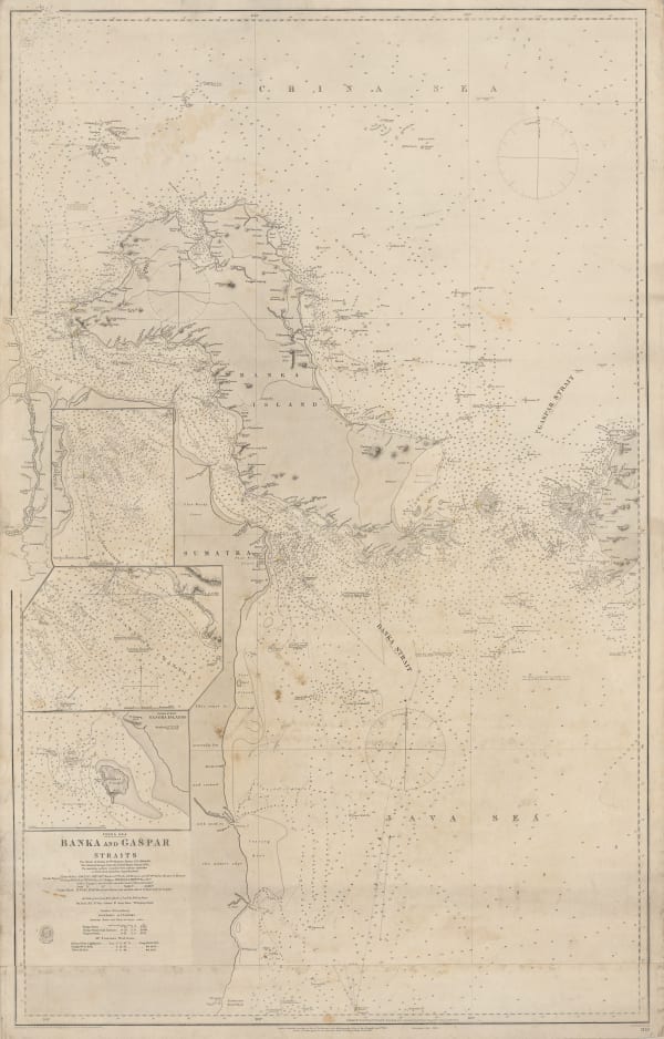
British Admiralty, Banka and Gaspar Straits, 1881£ 595.00
-
British Admiralty, Riau Islands, Indonesia, 1881£ 595.00
-
Royal Geographical Society (RGS), Map of North Borneo, 1881£ 425.00
-
British Admiralty, Strait of Malacca. From Diamond Pt. to the North Sands, 1882£ 795.00
-
John Bartholomew, Southeast Asia, 1887£ 64.00
-
A. Simon, Jakarta (Batavia) Port, 1888£ 325.00
-
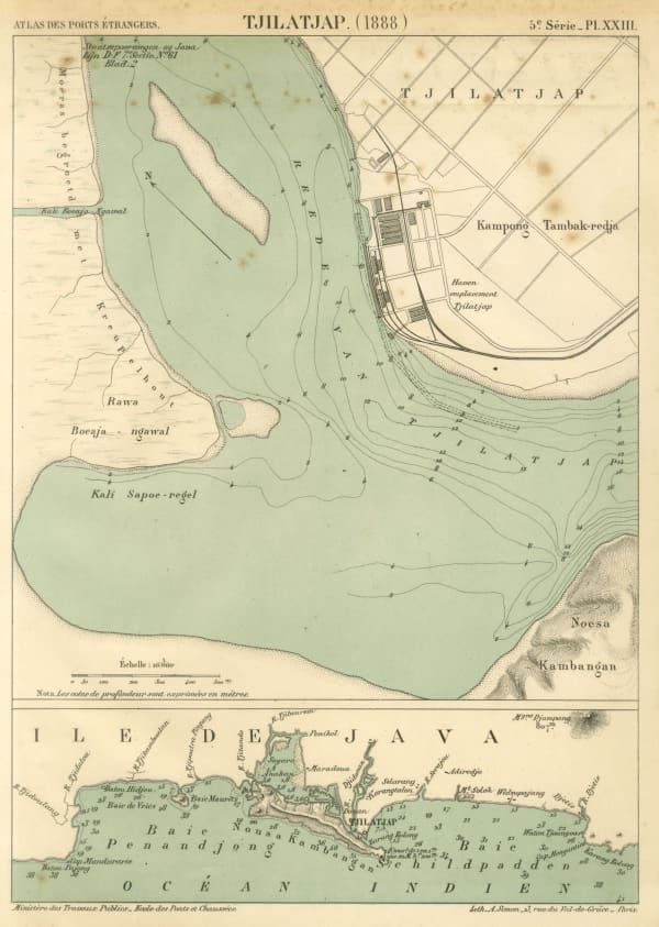
A. Simon, Cilacap (Tjilatjap) harbour and environs, 1888£ 195.00
-
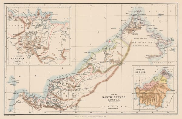
Royal Geographical Society (RGS), Map of British North Borneo, 1888£ 695.00
-
Richard Holmes Laurie, Sandakan Bay, 1889£ 52.00
-
Virtue & Co., Sunda Strait, 1890 c.£ 58.00
-
Royal Geographical Society (RGS), Brunei and Sarawak, 1893£ 725.00
-
Edward Stanford, East Indies, 1896£ 145.00
-
Royal Geographical Society (RGS), Map of the Baram District, Sarawak, Northern Borneo, 1900£ 1,150.00
-
Official Tourist Bureau (OTB), Vintage tourist map of Java, 1918£ 165.00
-
British Admiralty, Anamba Islands, 1927£ 325.00
-
War Office, Indonesia and New Guinea, 1928£ 875.00
-
Geographia Ltd., Indonesia, Borneo, Brunei, and the Philippines, 1930 (c.)£ 195.00
-
Dutch Topographical Service, Vintage map of Eastern Java and Bali, 1932£ 925.00
-
René Jouon, Indonesia or the Dutch East Indies, 1932£ 85.00
-
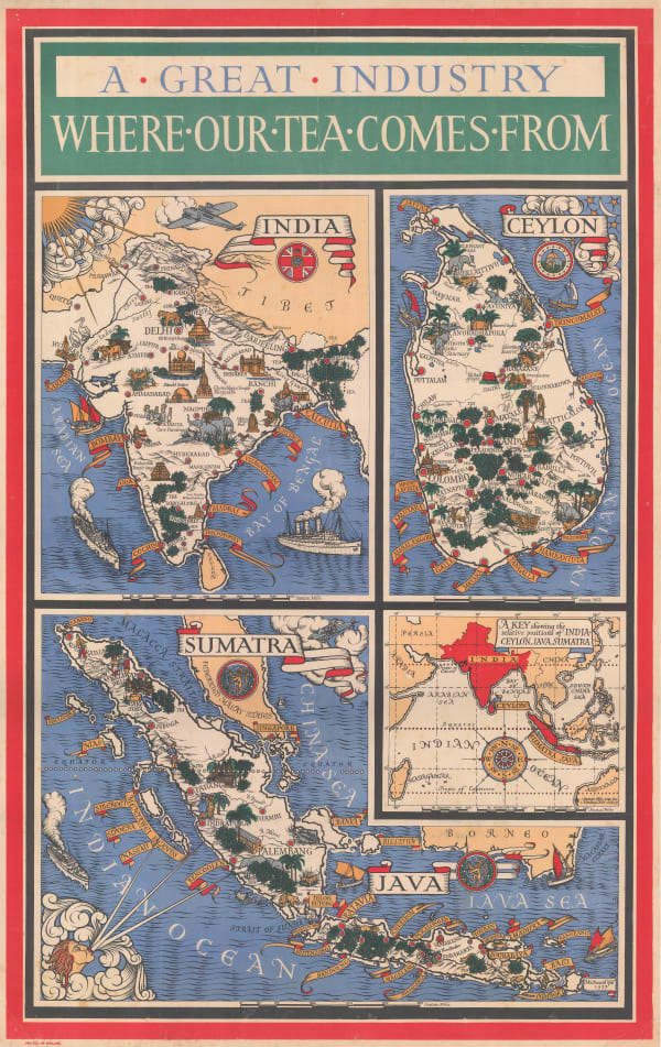
MacDonald Gill, A Great Industry - Where Our Tea Comes From, 1937£ 4,950.00
-
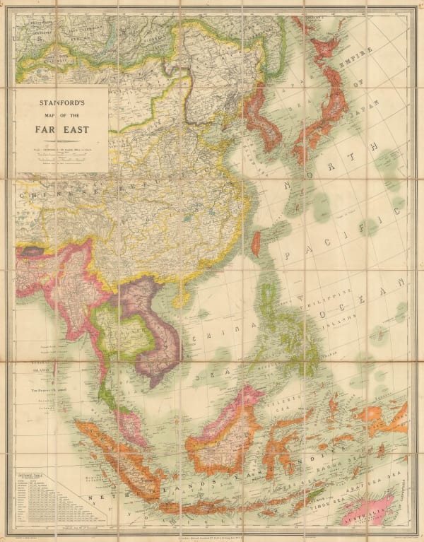
Edward Stanford, Folding wall map of South East Asia, 1941£ 1,450.00
-
Geographical Section, General Staff (GSGS), WW2 Map of the East Indies, 1942£ 450.00
-
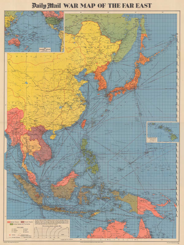
George Philip & Son Ltd., WW2 Map of the Far East, 1944£ 495.00


Page
2
of 2