-
 Johann Wolfgang Heydt, Plan of Jakarta (Batavia), 1744£ 495.00
 -
Herman Moll, Chart of the East Indies, 1745£ 795.00
-
Jakarta and the archipelago of Thousand Islands (Kepulauan Seribu), 1745Awnsham & John ChurchillSeries: LondonAwnsham & John Churchill, Jakarta and the archipelago of Thousand Islands (Kepulauan Seribu), 1745£ 195.00
-
Philippe Buache, India, China and the East Indies, 1745£ 2,500.00
-
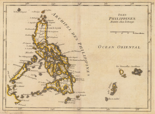
Georges-Louis Le Rouge, Philippine Islands, 1746£ 745.00
-
Jacques-Nicolas Bellin, China, Japan, Philippines & Southeast Asia, 1746£ 445.00
-
Emanuel Bowen, India and Southeast Asia, 1748£ 875.00
-
Homann Heirs, India and Southeast Asia, 1748£ 1,800.00
-
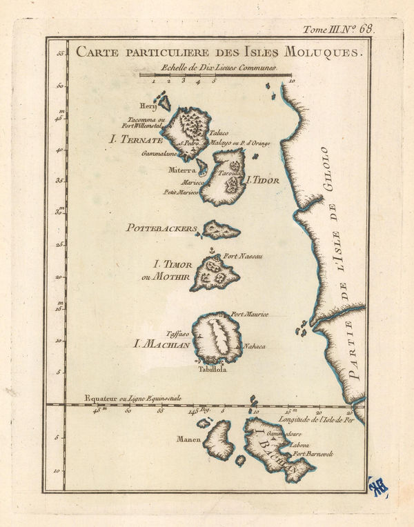
Georges-Louis Le Rouge, Isles Moluques, 1748 c.£ 345.00
-
Jacques-Nicolas Bellin, Chart of the Cambodia and Vietnam coast, 1749£ 195.00
-
Jacques-Nicolas Bellin, Chart of Malaysia, Borneo, Java and Sumatra, 1749£ 465.00
-
Jacques-Nicolas Bellin, Chart of the Philippines and Spice Islands, 1749 c.£ 425.00
-
Jacques-Nicolas Bellin, Ceram, Buru, Ambon and Banda Neira, 1750£ 185.00
-
Jacques-Nicolas Bellin, Jakarta, 1750£ 645.00
-
Jacques-Nicolas Bellin, Mergui (Myeik) Archipelago, 1750 c.£ 42.00
-
Jacques-Nicolas Bellin, Chart of Cacho and the Red River estuary, 1750 c.£ 165.00
-
Jacques-Nicolas Bellin, Plan of Ayutthaya, Thailand, 1751£ 495.00
-
Paolo Santini, India, Thailand, Vietnam, Tibet and Myanmar, 1751£ 625.00
-
Jacques-Nicolas Bellin, Northern Philippines, 1752£ 385.00
-
Jacques-Nicolas Bellin, Chart of the southern Philippines, 1752£ 245.00
-
Thomas Salmon, East Indies, 1752£ 375.00
-
-
-
Jacques-Nicolas Bellin, City plan of Lopburi (Louvo), 1755 c.£ 525.00
-
Herman Moll, Philippines, Indonesia and Malaysia, 1755 c.£ 495.00
-
Jacques-Nicolas Bellin, Sumatra and the Malacca Straits, 1760£ 450.00
-
Jacob van der Schley, Jakarta (Batavia), 1760 c.£ 525.00
-
Matthaus Seutter, South East Asia and India, 1760 c.£ 2,650.00
-
London Magazine, India and Southeast Asia, 1762£ 375.00
-
London Magazine, A Chart of the Channel through which the Manila Galeon Passes, 1763£ 795.00
-
Jacques-Nicolas Bellin, French map of Java, 1764£ 345.00
-
Jacques-Nicolas Bellin, Chart of the Chao Phraya River, Thailand , 1764£ 325.00
-
Ternate, Tidore, Mare, Moti, Makia and Bacan, North Maluku Islands, 1764Jacques-Nicolas BellinSeries: ParisJacques-Nicolas Bellin, Ternate, Tidore, Mare, Moti, Makia and Bacan, North Maluku Islands, 1764£ 125.00
-
Jacques-Nicolas Bellin, Port of Mergui and Island of Bader Moucan, 1764£ 195.00
-
Jacques-Nicolas Bellin, Manila Bay, 1764£ 850.00
-
Jacques-Nicolas Bellin, Lopburi, 1764£ 295.00
-
Jacques-Nicolas Bellin, Jakarta, 1764£ 325.00
-
Jacques-Nicolas Bellin, Malacca, 1764£ 295.00
-
Jacques-Nicolas Bellin, Thailand, Vietnam, Laos, Cambodia & Myanmar, 1764£ 745.00
-
Jacques-Nicolas Bellin, Sumatra, Singapore & Malaysia, 1764£ 395.00
-
Emanuel Bowen, India, Ceylon and part of South East Asia, 1766£ 975.00
-
Guillaume-Nicolas Delahaye, French sea chart of the Gulf of Thailand, 1770 c.£ 1,250.00
-
Rigobert Bonne, Wall map of India and Southeast Asia, 1771£ 1,250.00
-
Rigobert Bonne, India and Southeast Asia, 1771 c.£ 445.00
-
Willem Albert Bachiene, Southeast Asia, 1774£ 1,250.00
-
Willem Albert Bachiene, Ryk des Grooten Mogols en dier Indien, 1774£ 985.00
-
Robert Sayer, A Chart of the Straits of Sunda and Banca, 1778£ 775.00
-
Thomas Conder, East Indies, 1778£ 895.00
-
Francois Santini, Southeast Asia, 1778£ 525.00
-
Antonio Zatta, South East Asia, 1780£ 325.00
-
Philippines with parts of part of Indonesia, New Guinea, Taiwan and southeast China, 1780 cRigobert BonneRigobert Bonne, Philippines with parts of part of Indonesia, New Guinea, Taiwan and southeast China, 1780 c£ 550.00
-
Antonio Zatta, India and Southeast Asia, 1780 c.£ 1,150.00
-
Jean-Baptiste d'Après de Mannevillette, Sea Chart of Java, Indonesia, 1780 c.£ 925.00
-
Andrew Bell, East Indies, 1784£ 275.00
-
Antonio Zatta, India and Southeast Asia, 1784£ 625.00
-
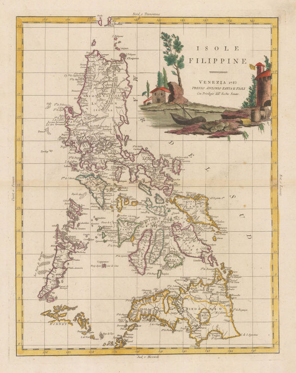
Antonio Zatta, Philippine Islands, 1785£ 1,950.00
-
Antonio Zatta, Malay Peninsula and Bay of Bengal, 1785£ 1,150.00
-
Henry Gregory, Sea Chart of the Gulf of Thailand (Siam), 1787£ 895.00
-
Rigobert Bonne, Indonesia, Malaysia and New Guinea, 1790 c£ 395.00
-
Charles Theodore Middleton, India and the East Indies, 1790 c.£ 325.00
-
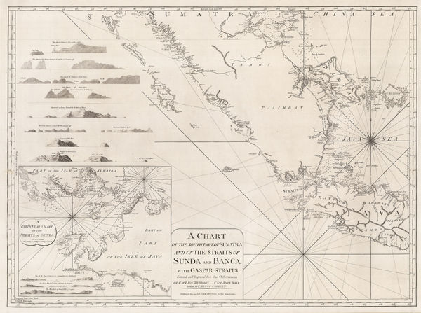
A Chart of the Southern Part of Sumatra and of the Straits of Sunda and Banca, 1794Laurie & WhittleSeries: LondonLaurie & Whittle, A Chart of the Southern Part of Sumatra and of the Straits of Sunda and Banca, 1794£ 925.00
-
Laurie & Whittle, Bali Strait, 1794£ 395.00
-
Laurie & Whittle, Chart of the west Coast of Sumatra, 1794£ 495.00
-
Laurie & Whittle, Phuket and the Mergui Archipelago, 1794£ 795.00
-
Laurie & Whittle, Chart of the Riau Islands in the Singapore Strait, 1794£ 1,250.00
-
Laurie & Whittle, Chart of Subic Bay on Luzon Island, 1794£ 825.00
-
The Coast of India and China from the Point and River of Camboja to Canton, 1794Laurie & WhittleSeries: LondonLaurie & Whittle, The Coast of India and China from the Point and River of Camboja to Canton, 1794£ 2,250.00
-
Laurie & Whittle, Rare chart of the Gulf of Thailand and the South China Sea, 1794£ 1,350.00
-
Charles Francois Delamarche, India and Southeast Asia, 1795£ 285.00
-
Charles Francois Delamarche, Southeast Asia, 1795£ 375.00
-
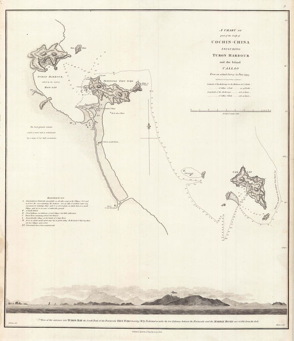
Sir George Staunton, Danang (Turon) Harbour, 1796£ 325.00
-
Giovanni Maria Cassini, Peninsular Southeast Asia, 1797£ 1,850.00
-
William Faden, India and Southeast Asia, 1798£ 175.00
-
-
William Heather, Two charts of Islands in the Banda Sea, 1800£ 2,950.00
-
Michael Symes, Myanmar (Burmese Empire) and Indo-China, 1800£ 245.00
-
George Cooke, Southeast Asia, 1800£ 175.00
-
Johann Christoph Reinecke, German atlas map of India, and South East Asia, 1801£ 1,250.00
-
British Admiralty, Plan of the River Saigon, 1802£ 675.00
-
William Heather, Chart of the Andaman and Nicobar Islands, 1803£ 3,200.00


![Johannes [II] van Keulen, Chart of the coast of Myanmar (Burma) and the Andaman Islands, 1753](https://static-assets.artlogic.net/w_600,c_limit,f_auto,fl_lossy,q_auto/artlogicstorage/themaphouse/images/view/9ab9fb3cd2bb1539bd4a22186f075456j/themaphouse-johannes-ii-van-keulen-chart-of-the-coast-of-myanmar-burma-and-the-andaman-islands-1753.jpg)


Page
2
of 5