-
 Martin Waldseemüller & Laurent Fries, West Africa, 1541£ 2,550.00
 -
Early woodcut map of West Africa and the Gulf of Guinea, 1556Giovanni Battista RamusioSeries: VeniceGiovanni Battista Ramusio, Early woodcut map of West Africa and the Gulf of Guinea, 1556£ 3,650.00
-
Petrus Bertius, Miniature map of the west coast of Africa, 1616£ 345.00
-
Mercator Hondius, West Africa & the Gulf of Guinea, 1623£ 1,550.00
-
Robert Morden, North & West Africa, 1688£ 125.00
-
Johannes van Keulen, Rare early chart of Gambia and Senegal coast, 1690 c.£ 465.00
-
Nicolas Sanson, West and Northwest Africa, 1700£ 475.00
-
Pierre Mortier, Chart of West Africa from Guinea to Ghana, 1700£ 1,450.00
-
Nicolas & Guillaume Sanson, West Africa & Cabo Verde, 1700£ 265.00
-
Guillaume De L'Isle, North & West Africa, 1707£ 445.00
-
Pierre Mortier, Sea Chart of West Africa & Atlantic Islands, 1708£ 1,350.00
-
Guillaume De L'Isle, De L'Isle's famous map of Senegal, 1727£ 475.00
-
Bowen & Gibson, Miniature map of West Africa, 1758£ 140.00
-
Jacob van der Schley, Senegal, Mauritania, and Mali, 1760 c.£ 295.00
-
Andrew Dury, Map of Senegal, with Part of the Coast of Africa, 1761£ 118.00
-
Jacques-Nicolas Bellin, Mouth of the River Senegal, 1764£ 68.00
-
Jacques-Nicolas Bellin, Chart of the Cape Verde Islands and the coast of Africa , 1765£ 225.00
-
Emanuel Bowen, West Africa, 1766£ 645.00
-
Malachy Postlethwayt, West Africa with a list of European Settlements, 1766£ 1,450.00
-
Thomas Jefferys, Western Africa from Cape Blanco to Cape Virga, 1768£ 1,250.00
-
Rigobert Bonne, Northwest Africa coast, Tangier to Sierra Leone, 1780 c.£ 90.00
-
Antonio Zatta, West Africa from Senegal to Ghana, 1784£ 175.00
-
John Pinkerton, Western Africa, 1813£ 475.00
-
Royal Geographical Society (RGS), West Coast of Africa, 1840 c.£ 125.00
-
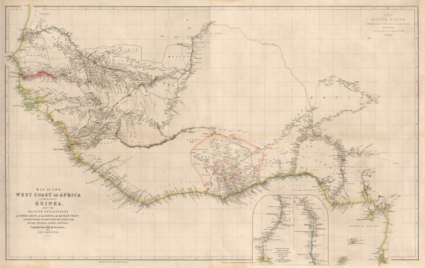
John Arrowsmith, Map of the West Coast of Africa, 1841£ 1,450.00
-
Joseph Meyer, West African coast, 1844£ 145.00
-
Justus Perthes, Sketch map of northern Senegal, 1858£ 68.00
-
A. Simon, Dakar, Senegal, 1876£ 195.00
-
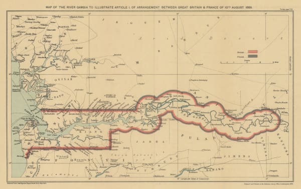
Edward Hertslet, Map of the River Gambia to Illustrate Article 1. of Arrangement Between Great Britain & France, 1909£ 44.00
-
Geographical Section, General Staff (GSGS), Folding map of West Africa, 1943£ 375.00
Close
Search Inventory
Our entire inventory of over 10,000 antique and vintage maps is now available to browse by region, date, cartographer, and subject


Join our mailing list
* denotes required fields
We will process the personal data you have supplied to communicate with you in accordance with our Privacy Policy. You can unsubscribe or change your preferences at any time by clicking the link in our emails.
![]()
Join our mailing list
* denotes required fields
We will process the personal data you have supplied to communicate with you in accordance with our Privacy Policy. You can unsubscribe or change your preferences at any time by clicking the link in our emails.