-
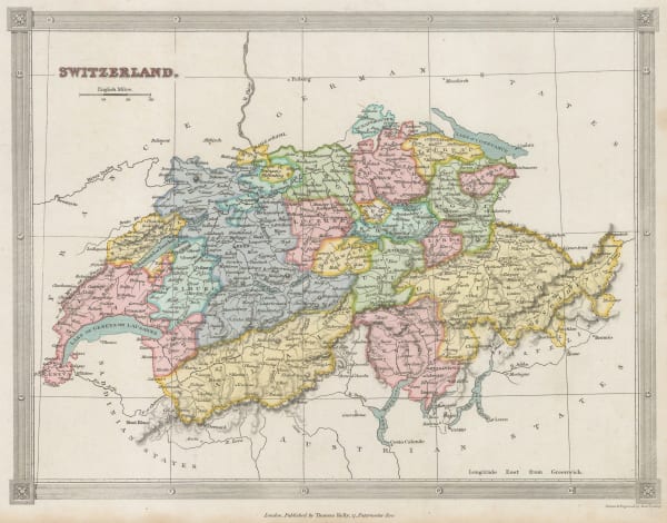
 Thomas Kelly, Switzerland, 1835 c.£ 85.00
 -
British Admiralty, The Harbour and Bays of Trincomalee, 1835 c.£ 490.00
-
Henry Teesdale, Warwickshire, 1835 c.£ 95.00
-
Rest Fenner, Asia, 1836£ 75.00
-
Rest Fenner, Asia Minor, 1836£ 65.00
-
Adrien Brue, Asiatic Russia, 1836£ 145.00
-
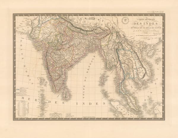
Adrien Brue, Indian and Southeast Asia showing European colonial possessions, 1836£ 245.00
-
Adrien Brue, Italy, Sicily, Sardinia and Corsica, 1836£ 165.00
-
Rest Fenner, Colony of New South Wales, 1836£ 125.00
-
J. & C. Walker, Cumberland, 1836£ 68.00
-
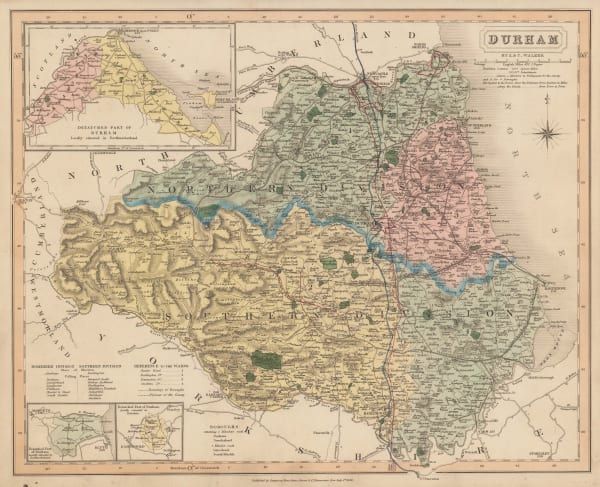
J. & C. Walker, Durham, 1836£ 82.00
-
Rest Fenner, Miniature map of Southeast Asia, 1836£ 85.00
-
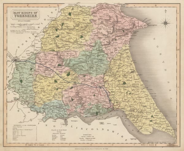
J. & C. Walker, East Riding of Yorkshire, 1836£ 72.00
-
Royal Geographical Society (RGS), Map of the Discoveries and Route of the Arctic Land Expedition, 1836£ 425.00
-
-
Rest Fenner, North America, 1836£ 95.00
-
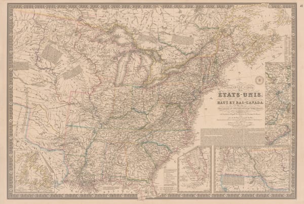
Adrien Brue, United States showing westward expansion, 1836£ 895.00
-
James Fraser, Panoramic Plan of London, 1836£ 1,350.00
-
Royal Geographical Society (RGS), Coast of Morocco and Western Sahara, 1836£ 65.00
-
Thomas Kelly, Peru and Bolivia, 1836£ 70.00
-
Royal Geographical Society (RGS), Plan of the Rivers Ucayali & Amazon from the Mission of Sarayacu to the Rio Negro, 1836£ 375.00
-
Rest Fenner, Portugal, 1836£ 52.00
-
Rest Fenner, Russia in Europe, 1836£ 65.00
-
J. & C. Walker, Shropshire, 1836£ 55.00
-
Rest Fenner, West Indies, 1836£ 78.00
-
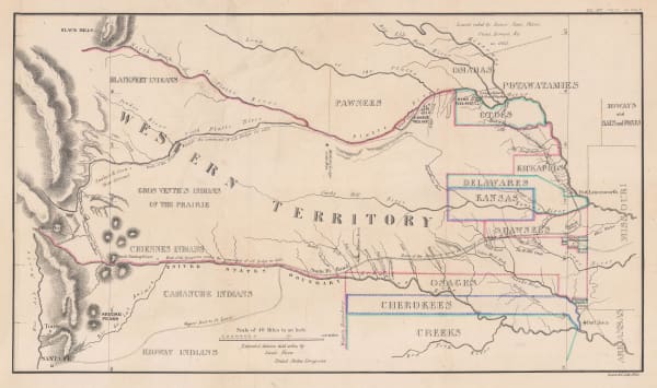
Enoch Steen, Dodge's Expedition through Kansas & Colorado, 1836£ 950.00
-
William Buckland, Ideal Cross-Section of the Earth, 1836£ 2,500.00
-
Rest Fenner, Egypt, 1836£ 75.00
-
Rest Fenner, Scotland, 1836£ 75.00
-
Rest Fenner, South America, 1836£ 85.00
-
Rest Fenner, Sweden and Norway, 1836£ 65.00
-
Rest Fenner, South Africa, 1836£ 85.00
-
Rest Fenner, Switzerland, 1836£ 75.00
-
George & John Cary, Cary's New Plan of London and its Vicinity, 1836£ 2,250.00
-
Rest Fenner, Polynesia and the Pacific , 1836£ 75.00
-
Rest Fenner, Greece, 1836£ 68.00
-
Rest Fenner, The Peloponnese Peninsula, 1836£ 64.00
-
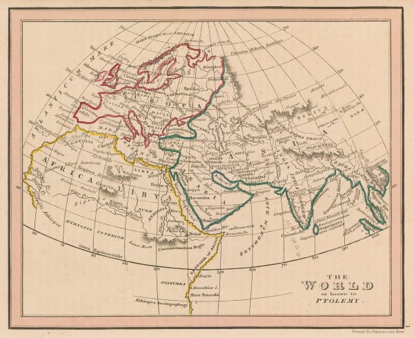
Rest Fenner, The World as known to Ptolemy, 1836£ 68.00
-
Henry Schenck Tanner, Arabia, Persia (Iran), and Afghanistan, 1836 c.£ 395.00
-
J. & C. Walker, A Geological Map of England, Wales, and Part of Scotland, 1837£ 4,500.00
-
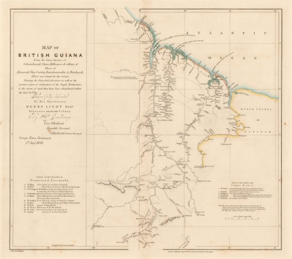
Royal Geographical Society (RGS), British Guayana, 1837£ 195.00
-
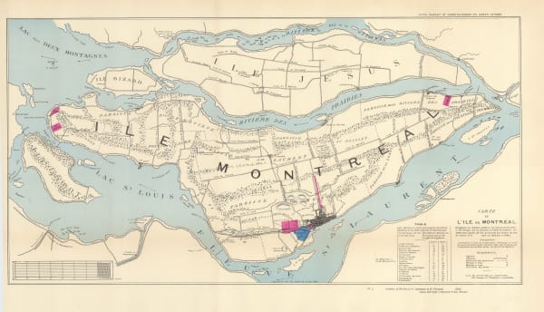
Hansard, Montreal Island, 1837£ 525.00
-
Adrien Brue, Carte de la Russie Occidentale et du Royme. de Pologne, 1837£ 185.00
-
Royal Geographical Society (RGS), Hudson's Strait, 1837£ 95.00
-
Washington Hood, Map - Illustrating the plan of the defences of the Western & North-Western Frontier, 1837£ 625.00
-
Royal Geographical Society (RGS), Ancient settlements of Minoa and Nisea, 1837£ 58.00
-
Society for the Diffusion of Useful Knowledge (SDUK), Southern Brazil, Paraguay and Uruguay, 1837£ 145.00
-
J. & C. Walker, Sussex, 1837£ 145.00
-
James Wyld, The World on Mercator's Projection, 1837£ 1,950.00
-
Duncan Bradford, Herschel's Forty-Foot Reflecting Telescope, 1837 c.£ 350.00
-
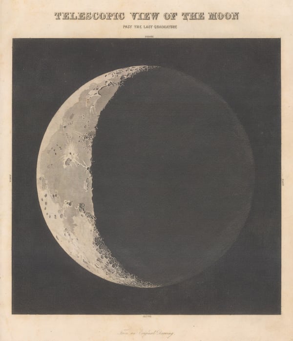
Duncan Bradford, Telescopic View of the Moon, Past the Last Quadrature, 1837 c.£ 700.00
-
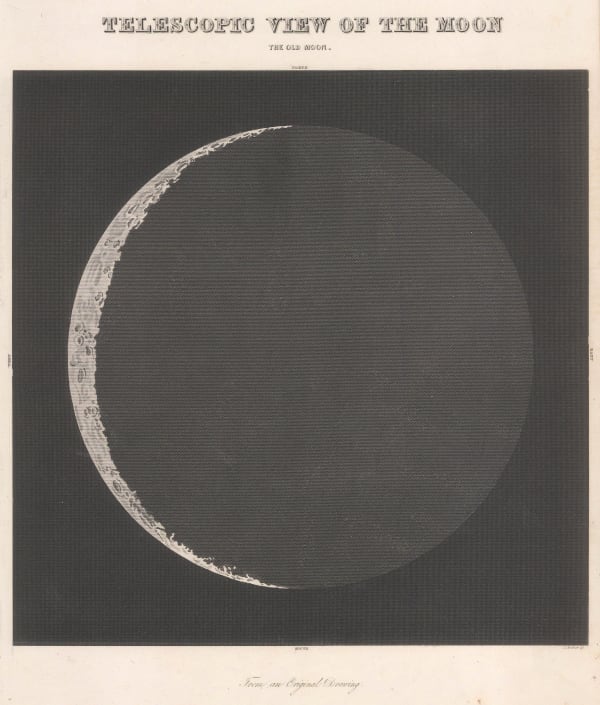
Duncan Bradford, Telescopic View of the Moon, The Old Moon, 1837 c.£ 700.00
-
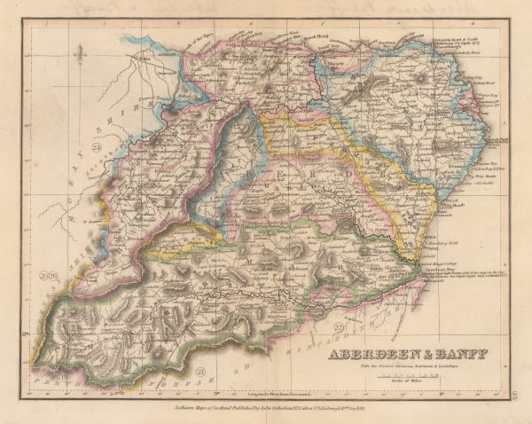
John Lothian, Aberdeen & Banff, 1838£ 145.00
-
James Wyld, Cape District Cape of Good Hope, 1838£ 1,150.00
-
Royal Geographical Society (RGS), Capt. Alexander's Route in South Africa, 1838£ 425.00
-
Spanish Admiralty, Chart of Florida, Bahamas and Cuba , 1838£ 4,850.00
-
Clement Adrien Vincendon-Dumoulin, French sea chart of Fiji and Samoa, 1838£ 595.00
-
Alexandre Emile Lapie, Mongolia, Tibet and China, 1838£ 185.00
-
Alexandre Emile Lapie, South America, 1838£ 235.00
-
Felix Delamarche, North America, 1838£ 120.00
-
Richard Holmes Laurie, Commencement of the Roads to Holyhead, as far as (13) Stratford on Avon, Warwick, Coventry & Hinckley, 1838£ 45.00
-
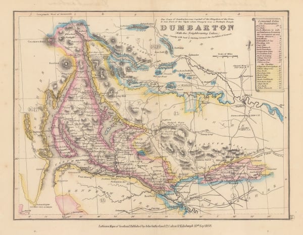
John Lothian, Dumbarton (with the neighbouring lakes), 1838£ 165.00
-
James Wyld, Environs of London, 1838£ 1,550.00
-
John Lothian, Inverness - Western Portion, 1838£ 175.00
-
John Lothian, Kincardine, 1838£ 125.00
-
John Arrowsmith, Map of British Guiana (Guyana), 1838£ 475.00
-
Washington Hood, Map of the United States Territory of Oregon West of the Rocky Mountains, 1838£ 2,450.00
-
Josiah Henshall, Tunbridge Wells, 1838£ 650.00
-
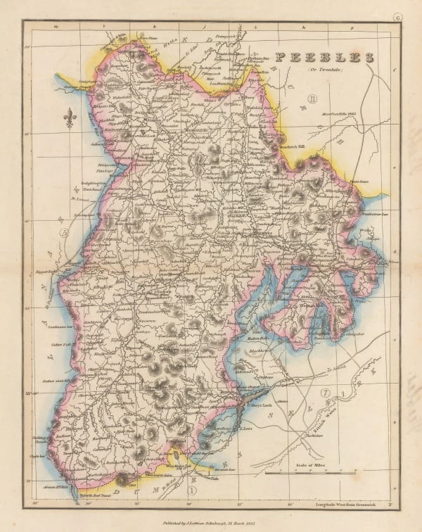
John Lothian, Peebles, 1838£ 145.00
-
John Lothian, Perth - North Portion, 1838£ 145.00
-
John Lothian, Renfrew, 1838£ 145.00
-
Royal Geographical Society (RGS), Route of Sir Grenville Temple from Bonah to Kostantinah, 1838£ 58.00
-
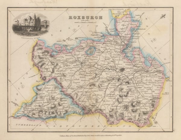
John Lothian, Roxburgh, 1838£ 145.00
-
Royal Geographical Society (RGS), Sketch of The Northern Route from Mokha to Sana, 1838£ 115.00
-
Society for the Diffusion of Useful Knowledge (SDUK), Patagonia, Chile, Tierra del Fuego and The Falklands, 1838£ 195.00
-
Society for the Diffusion of Useful Knowledge (SDUK), Spain and Portugal, 1838£ 45.00
-
Royal Geographical Society (RGS), The Gulf of Cambay, 1838£ 75.00
-
Society for the Diffusion of Useful Knowledge (SDUK), Western Siberia, Independent Tartary, Khiva, Bokhara &c., 1838£ 120.00
-
James Wellsted, Mount Sinai Peninsula, 1838£ 395.00
-
John Arrowsmith, Eastern Canada and New England, 1838£ 295.00


Page
66
of 130